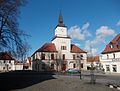
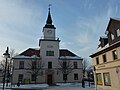
Category:Rathaus Hohenmölsen
Jump to navigation
Jump to search
| Object location | | View all coordinates using: OpenStreetMap |
|---|
| Upload media | |||||
| Instance of | |||||
|---|---|---|---|---|---|
| Location | Hohenmölsen, Burgenlandkreis, Saxony-Anhalt, Germany | ||||
| Heritage designation | |||||
 | |||||
This is the category of the Saxony-Anhalt Kulturdenkmal (cultural heritage monument) with the ID 09487048 (Wikidata)
|
Media in category "Rathaus Hohenmölsen"
The following 4 files are in this category, out of 4 total.
-
 HHM-Rathaus.JPG 3,534 × 2,680; 1.2 MB
-
 Rathaus Hohenmölsen.jpg 3,347 × 3,992; 2.81 MB
-
 Rathaus Hohenmölsen2.jpg 3,893 × 4,946; 4.49 MB
-
 Rathaus-Hohenmölsen.jpg 1,440 × 1,080; 191 KB


