Category:Rathkeale
Vai alla navigazione
Vai alla ricerca
English: Rathkeale is a town in west County Limerick, Ireland. It is located 30 km (18 mi) southwest of Limerick city on the N21 road to Tralee, and lies on the River Deel. Rathkeale has a significant Irish Traveller population.
Svenska: Rathkeale ( iriska: Ráth Caola) är ett samhälle i grevskapet Limerick i Republiken Irland. Rathkeale ligger i närheten av staden Limerick, på floden Deel.
human settlement in County Limerick, Ireland  | |||||
| Carica un file multimediale | |||||
| Istanza di | |||||
|---|---|---|---|---|---|
| Luogo | Limerick, Munster, Irlanda | ||||
| Altezza sul mare |
| ||||
 | |||||
Sottocategorie
Questa categoria contiene un'unica sottocategoria, indicata di seguito.
File nella categoria "Rathkeale"
Questa categoria contiene 12 file, indicati di seguito, su un totale di 12.
-

-
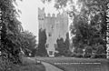 Castle Matrix, Rathkeale, Limerick (5260848200).jpg 600 × 392; 78 KB
-
 Duelling Dye Works? (5260240821).jpg 2 000 × 1 305; 1,2 MB
-
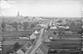
 Main St., Rathkeale, Limerick (5415763073).jpg 600 × 397; 61 KB
-
 Mick Neville Park jpeg.jpg 7 378 × 4 924; 1,42 MB
-
 Rathkeale fire station - geograph.org.uk - 581945.jpg 640 × 301; 48 KB
-
 Rathkeale, Limerick (5260240713).jpg 600 × 392; 47 KB
-
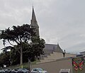 Rathkeale, Saint Mary's Catholic Church.jpg 5 106 × 4 382; 2,59 MB
-
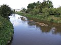 River Deel - geograph.org.uk - 581931.jpg 640 × 480; 88 KB
-
 Road Junction - geograph.org.uk - 5588959.jpg 1 600 × 1 200; 322 KB
-
 Southbound N21 near Rathkeale - geograph.org.uk - 6321226.jpg 800 × 533; 501 KB
-
 Southbound N21, Rathkeale - geograph.org.uk - 6321228.jpg 800 × 533; 583 KB
.jpg)
.jpg)
.jpg)


.jpg)


