Category:Reach, Cambridgeshire
Jump to navigation
Jump to search
العربية: ريتش (كامبريدجشير) هي civil parish تقع في المملكة المتحدة في إنجلترا. يقدر عدد سكانها بـ 358 نسمة .
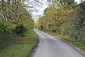
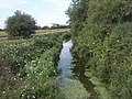
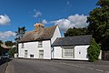
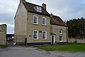
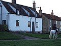
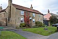
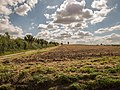
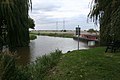
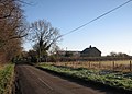
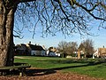
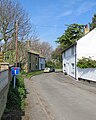
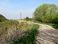
English: Reach is a small village and civil parish on the edge of the fenland in East Cambridgeshire, England at the north end of Devil's Dyke, about west of Burwell.
Nederlands: Reach is een plaats en civil parish in het bestuurlijke gebied East Cambridgeshire, in het Engelse graafschap Cambridgeshire met 365 inwoners.
Polski: Reach – wieś w Anglii, w hrabstwie Cambridgeshire, w dystrykcie East Cambridgeshire. Leży 15 km na północny wschód od miasta Cambridge i 90 km na północ od Londynu. W 2001 miejscowość liczyła 365 mieszkańców.

village in the United Kingdom  | |||||
| Upload media | |||||
| Instance of | |||||
|---|---|---|---|---|---|
| Location | East Cambridgeshire, Cambridgeshire, East of England, England | ||||
| official website | |||||
 | |||||
Subcategories
This category has the following 3 subcategories, out of 3 total.
Media in category "Reach, Cambridgeshire"
The following 200 files are in this category, out of 231 total.
(previous page) (next page)-
 "Adventurer" in Spring - geograph.org.uk - 3459881.jpg 1,024 × 1,024; 397 KB
-
 21, Great Lane - geograph.org.uk - 6049726.jpg 1,024 × 681; 167 KB
-
 24, High St - geograph.org.uk - 6048036.jpg 1,024 × 681; 181 KB
-
 A long view from The Devil's Dyke - geograph.org.uk - 6239123.jpg 1,024 × 732; 882 KB
-
 A swan beside Reach Lode - geograph.org.uk - 6124168.jpg 819 × 1,024; 1.07 MB
-
 Across the fields to Burwell - geograph.org.uk - 6239109.jpg 1,024 × 768; 854 KB
-

-
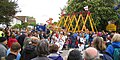
 All the Fun of Reach Fair - geograph.org.uk - 3459965.jpg 1,024 × 768; 220 KB
-
 Along Devil's Dyke - geograph.org.uk - 5988601.jpg 3,264 × 2,448; 1.85 MB
-
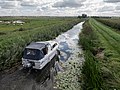
 Another fine mess you've got me into^ - geograph.org.uk - 3460002.jpg 1,024 × 768; 220 KB
-
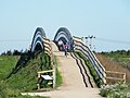
 Approach to Cycle Bridge over Reach Lode - geograph.org.uk - 4145386.jpg 1,600 × 1,067; 574 KB
-
 Approaching Reach from the south - geograph.org.uk - 1206508.jpg 640 × 480; 78 KB
-
 Barston Drove - geograph.org.uk - 6055399.jpg 1,024 × 681; 176 KB
-
 Barston Drove - geograph.org.uk - 6055400.jpg 1,024 × 681; 235 KB
-
 Barston Drove - geograph.org.uk - 6055404.jpg 1,024 × 681; 212 KB
-
 Barston Drove - geograph.org.uk - 6055407.jpg 1,024 × 681; 226 KB
-
 Barston Drove - geograph.org.uk - 6055410.jpg 1,024 × 681; 255 KB
-
 Barston Drove - geograph.org.uk - 6055411.jpg 1,024 × 681; 255 KB
-
 Barston Drove - geograph.org.uk - 6055418.jpg 1,024 × 681; 236 KB
-
 Barston Drove - geograph.org.uk - 6055423.jpg 1,024 × 681; 172 KB
-
 Barston Drove, nearing Reach - geograph.org.uk - 2753293.jpg 1,024 × 768; 1.28 MB
-
 Barston Drove, the edge of the fen - geograph.org.uk - 2753074.jpg 1,024 × 768; 1.16 MB
-
 Bench overlooking Burwell Fen - geograph.org.uk - 4504739.jpg 6,000 × 4,000; 5.65 MB
-
 Bend And Bridge - geograph.org.uk - 5520570.jpg 1,024 × 769; 161 KB
-
 Bird hide on Tubney Fen near Reach - geograph.org.uk - 3864510.jpg 2,848 × 2,136; 2.96 MB
-
 Bridge over Reach Lode on Tubney Fen - geograph.org.uk - 3865397.jpg 2,848 × 2,136; 3.01 MB
-
 Bull Cottage - detail - geograph.org.uk - 1206542.jpg 640 × 480; 97 KB
-
 Burwell Church tower framed by a pylon - geograph.org.uk - 4272890.jpg 1,024 × 732; 1.06 MB
-
 Burwell Road - geograph.org.uk - 4706429.jpg 640 × 480; 73 KB
-
 Burwell Road - geograph.org.uk - 4706430.jpg 640 × 480; 70 KB
-

-
 Cambridgeshire farmland - geograph.org.uk - 6047455.jpg 1,024 × 681; 159 KB
-
 Cambridgeshire farmland - geograph.org.uk - 6047456.jpg 1,024 × 681; 184 KB
-
 Catch Water Drain becoming Reach Lode - geograph.org.uk - 2092351.jpg 1,600 × 1,200; 925 KB
-
 Catch Water Drain, Reach - geograph.org.uk - 2517549.jpg 640 × 480; 112 KB
-
 Chalk pit, Reach - geograph.org.uk - 2825932.jpg 1,600 × 1,067; 743 KB
-
 Chapel Lane - geograph.org.uk - 5197022.jpg 1,024 × 767; 224 KB
-
 Church in Reach - geograph.org.uk - 5955767.jpg 768 × 1,024; 169 KB
-
 Cmglee Reach Fair dog show.jpg 3,072 × 2,048; 1,024 KB
-
 Cmglee Reach Fair Maypole.jpg 4,096 × 2,048; 1,024 KB
-
 Cmglee Reach Fair penny throw.jpg 1,535 × 1,024; 256 KB
-
 Cottage in Reach - geograph.org.uk - 6048727.jpg 1,024 × 681; 135 KB
-
 Cottage on the corner - geograph.org.uk - 6048912.jpg 1,024 × 681; 166 KB
-
 Cottage on The Hythe - geograph.org.uk - 4145349.jpg 1,600 × 1,067; 384 KB
-
 Cottage, Great Lane - geograph.org.uk - 6049042.jpg 1,024 × 681; 179 KB
-
 Cottage, Great Lane - geograph.org.uk - 6055397.jpg 1,024 × 681; 130 KB
-
 Cottages, Reach - geograph.org.uk - 4706423.jpg 640 × 480; 68 KB
-
 Cow beside Hightown Drove - geograph.org.uk - 4145402.jpg 1,600 × 1,067; 636 KB
-
 Cows Beside Hightown Drove - geograph.org.uk - 4145399.jpg 1,600 × 1,067; 478 KB
-
 Cycle Bridge - geograph.org.uk - 5197013.jpg 1,024 × 768; 256 KB
-
 Dancing the Maypole at Reach Fair - geograph.org.uk - 1286214.jpg 640 × 480; 118 KB
-
 Devil's Ditch and Dyke - geograph.org.uk - 1206521.jpg 640 × 480; 73 KB
-
 Devil's Dyke - geograph.org.uk - 363422.jpg 640 × 427; 66 KB
-
 Devil's Dyke - geograph.org.uk - 363429.jpg 640 × 427; 64 KB
-
 Devil's Dyke - geograph.org.uk - 6047454.jpg 1,024 × 681; 208 KB
-
 Devil's Dyke - geograph.org.uk - 6047459.jpg 1,024 × 681; 271 KB
-
 Devil's Dyke - geograph.org.uk - 6047461.jpg 1,024 × 681; 270 KB
-
 Devil's Dyke - geograph.org.uk - 6047462.jpg 1,024 × 681; 250 KB
-
 Devil's Dyke - geograph.org.uk - 6047465.jpg 1,024 × 681; 253 KB
-
 Devil's Dyke - geograph.org.uk - 6047466.jpg 1,024 × 681; 246 KB
-
 Ditch across Burwell Fen - geograph.org.uk - 2092325.jpg 1,600 × 1,200; 956 KB
-
 Ditch, Devil's Dyke - geograph.org.uk - 6047453.jpg 1,024 × 681; 216 KB
-
 Ditchfield, Reach - geograph.org.uk - 1206526.jpg 640 × 480; 58 KB
-
 Dykes End public house, Reach - geograph.org.uk - 5461013.jpg 3,456 × 2,592; 3.87 MB
-
 Earthworks, Reach - geograph.org.uk - 2825922.jpg 1,600 × 1,067; 533 KB
-
 Entering Reach - geograph.org.uk - 4706420.jpg 640 × 480; 66 KB
-
 Fair Green, Reach - geograph.org.uk - 6047481.jpg 1,024 × 681; 192 KB
-
 Farmland off National Cycle Route 51 - geograph.org.uk - 4706417.jpg 640 × 480; 67 KB
-
 Fen View from Reach Lode - geograph.org.uk - 2711498.jpg 2,048 × 810; 352 KB
-
 Field edge - geograph.org.uk - 6047460.jpg 1,024 × 681; 158 KB
-

-
 Field near Reach - geograph.org.uk - 4702035.jpg 640 × 480; 66 KB
-
 Fields sloping up from the edge of the fen - geograph.org.uk - 2753279.jpg 1,024 × 768; 1.33 MB
-
 Footpath along Reach Lode - geograph.org.uk - 2160494.jpg 1,600 × 1,200; 1.09 MB
-
 Footpath And Byway Sign - geograph.org.uk - 5520558.jpg 768 × 1,024; 357 KB
-
 Footpath from Reach - geograph.org.uk - 2825958.jpg 1,600 × 1,067; 1,009 KB
-
 Footpath Next To Reach Lode - geograph.org.uk - 5197018.jpg 768 × 1,024; 244 KB
-
 Footpath to Burwell - geograph.org.uk - 6238749.jpg 1,024 × 768; 992 KB
-
 Footpath to Reach - geograph.org.uk - 2092335.jpg 1,600 × 1,200; 1.21 MB
-
 Footpath to Reach - geograph.org.uk - 2092342.jpg 1,600 × 1,200; 832 KB
-
 Footpath to Reach - geograph.org.uk - 2825899.jpg 1,600 × 1,067; 852 KB
-
 Fullers Farmhouse - geograph.org.uk - 6048964.jpg 1,024 × 681; 228 KB
-
 Gate - geograph.org.uk - 3241502.jpg 1,024 × 768; 270 KB
-
 Grassland near Wicken Fen - geograph.org.uk - 2825969.jpg 1,600 × 1,067; 762 KB
-
 Green Lane - geograph.org.uk - 6055420.jpg 1,024 × 681; 209 KB
-
 Green Lane, Reach - geograph.org.uk - 2825905.jpg 1,600 × 1,067; 666 KB
-
 Hanging sign for The Dykes End - geograph.org.uk - 5461015.jpg 2,592 × 3,456; 2.31 MB
-
 Heading north east from Reach - geograph.org.uk - 4706427.jpg 640 × 480; 75 KB
-
 High Cloud Stud - geograph.org.uk - 1206589.jpg 640 × 480; 93 KB
-
 Hill Farmhouse - geograph.org.uk - 6047491.jpg 1,024 × 681; 159 KB
-
 Horse rider in Reach - geograph.org.uk - 3864042.jpg 2,848 × 2,136; 3.02 MB
-
 House, Fair Green - geograph.org.uk - 6047477.jpg 1,024 × 681; 187 KB
-
 Lane junction - geograph.org.uk - 6049752.jpg 1,024 × 681; 185 KB
-
 Little Fen Drove - geograph.org.uk - 4145353.jpg 1,600 × 1,200; 678 KB
-
 Looking across Fair Green, Reach - geograph.org.uk - 6047480.jpg 1,024 × 681; 120 KB
-

-

-
 Misty Day - geograph.org.uk - 3241505.jpg 1,024 × 768; 127 KB
-
 Moorings at Reach - geograph.org.uk - 2617445.jpg 640 × 427; 68 KB
-
 Moorings at Reach Lode - geograph.org.uk - 2618216.jpg 640 × 427; 84 KB
-
 Morris dancing at Reach Fair 2011 - geograph.org.uk - 2398760.jpg 1,024 × 768; 234 KB
-
 Morris Dancing at Reach Fair 2017 - geograph.org.uk - 5373108.jpg 1,000 × 750; 217 KB
-
 Myster House - geograph.org.uk - 6048862.jpg 1,024 × 681; 141 KB
-
 Nearing Burwell - geograph.org.uk - 4272920.jpg 1,024 × 731; 991 KB
-
 Nearing Reach - geograph.org.uk - 2753863.jpg 1,024 × 765; 951 KB
-
 New cyclepath to Wicken Fen - geograph.org.uk - 2825988.jpg 1,600 × 1,067; 701 KB
-
 New wetlands near Reach Bridge and Lode - geograph.org.uk - 3865410.jpg 2,848 × 2,136; 3.05 MB
-
 North-east Reach, Fair Day 2012 - geograph.org.uk - 2933495.jpg 1,024 × 768; 216 KB
-
 North-west Reach, Fair Day 2012 - geograph.org.uk - 2933325.jpg 1,024 × 768; 195 KB
-
 North-west Reach, Fair Day 2012 - geograph.org.uk - 2933339.jpg 1,024 × 768; 203 KB
-
 Old railway bridge near Reach - geograph.org.uk - 1206472.jpg 640 × 480; 83 KB
-
 On Devil's Dyke near Reach - geograph.org.uk - 3864026.jpg 2,848 × 2,136; 3.13 MB
-
 Once the Mildenhall Branch Line - geograph.org.uk - 2753041.jpg 800 × 576; 693 KB
-
 Out of Reach - geograph.org.uk - 4272930.jpg 1,024 × 1,024; 1.47 MB
-
 Path along the Devil's Dyke, north-west end - geograph.org.uk - 2999656.jpg 1,024 × 768; 181 KB
-
 Potato harvest, Burwell Fen - geograph.org.uk - 4702049.jpg 640 × 480; 74 KB
-
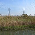
 Power Lines - geograph.org.uk - 5196679.jpg 768 × 1,024; 149 KB
-
 Prepared field by Straight Drove - geograph.org.uk - 4244494.jpg 1,600 × 1,200; 740 KB
-
 Pump at the Dykes End, Reach - geograph.org.uk - 5461019.jpg 2,592 × 3,456; 3.17 MB
-
 Pylon by Little Fen Drove - geograph.org.uk - 4145356.jpg 1,600 × 1,200; 507 KB
-
 Pylons across Burwell Fen - geograph.org.uk - 2092348.jpg 1,600 × 1,200; 648 KB
-
 Pylons near Reach - geograph.org.uk - 1461921.jpg 640 × 480; 68 KB
-
 Pylons on Burwell Fen - geograph.org.uk - 6124153.jpg 1,024 × 1,024; 1.26 MB
-
 Ramp up to Reach Bridge - geograph.org.uk - 3865389.jpg 2,848 × 2,136; 3.16 MB
-
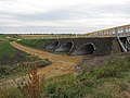
 Reach Bridge (2) - geograph.org.uk - 1192995.jpg 640 × 480; 91 KB
-
 Reach Bridge - geograph.org.uk - 1192993.jpg 640 × 480; 85 KB
-
 Reach Bridge to The Devil's Dyke - geograph.org.uk - 2753877.jpg 1,024 × 768; 971 KB
-
 Reach Cemetery - geograph.org.uk - 4272977.jpg 819 × 1,024; 1.43 MB
-
 Reach Cemetery - geograph.org.uk - 4706421.jpg 640 × 480; 91 KB
-
 Reach cemetery - geograph.org.uk - 5461589.jpg 3,456 × 2,592; 3.88 MB
-
 Reach Fair - Remix - geograph.org.uk - 1286276.jpg 640 × 480; 84 KB
-
 Reach Fair 2012 - geograph.org.uk - 2933410.jpg 1,024 × 768; 238 KB
-
 Reach Fair 800th Anniversary plaque - geograph.org.uk - 1206532.jpg 640 × 480; 100 KB
-
 Reach Fair Proclamation 2009 - geograph.org.uk - 1286176.jpg 640 × 480; 108 KB
-
 Reach Fair, Cambridgeshire - geograph.org.uk - 2780241.jpg 1,024 × 768; 144 KB
-
 Reach Lode - geograph.org.uk - 4145390.jpg 1,600 × 1,200; 600 KB
-
 Reach Lode - geograph.org.uk - 4145394.jpg 1,600 × 1,200; 562 KB
-
 Reach Lode - geograph.org.uk - 4504761.jpg 6,000 × 4,000; 4.06 MB
-
 Reach Lode - geograph.org.uk - 5419199.jpg 1,600 × 1,108; 403 KB
-
 Reach Lode and bridge - geograph.org.uk - 3865402.jpg 2,848 × 2,136; 3.04 MB
-
 Reach Lode and bridge on Tubney Fen - geograph.org.uk - 3865406.jpg 2,848 × 2,136; 3.05 MB
-
 Reach Lode Bridge - geograph.org.uk - 2106416.jpg 640 × 480; 67 KB
-
 Reach Lode bridge - geograph.org.uk - 2160470.jpg 1,600 × 1,200; 1.02 MB
-
 Reach Lode bridge - geograph.org.uk - 2160482.jpg 1,600 × 1,200; 1.06 MB
-
 Reach Lode Bridge - geograph.org.uk - 2632131.jpg 640 × 427; 78 KB
-
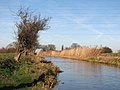 Reach Lode in January - geograph.org.uk - 2753577.jpg 1,024 × 768; 1.06 MB
-
 Reach Port information board - geograph.org.uk - 2092350.jpg 1,600 × 1,200; 670 KB
-
 Reach Village - geograph.org.uk - 31663.jpg 640 × 480; 78 KB
-
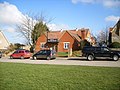 Reach Village Centre - geograph.org.uk - 1192998.jpg 640 × 480; 82 KB
-
 Reach Village Centre - geograph.org.uk - 6047852.jpg 1,024 × 681; 172 KB
-
 Reach Village Sign - geograph.org.uk - 5461021.jpg 2,592 × 3,456; 2.39 MB
-
 Reach Village sign - geograph.org.uk - 6047490.jpg 681 × 1,024; 175 KB
-
 Reach War Memorial - geograph.org.uk - 2692285.jpg 3,888 × 2,592; 6.09 MB
-
 Reach War Memorial - geograph.org.uk - 5461007.jpg 3,456 × 2,592; 3.91 MB
-
 Reach War Memorial - geograph.org.uk - 6047848.jpg 1,024 × 681; 162 KB
-
 Reach wood - geograph.org.uk - 823082.jpg 1,024 × 768; 326 KB
-
 Reach, a cottage on The Hythe - geograph.org.uk - 6124065.jpg 1,024 × 1,024; 1.37 MB
-
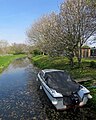 Reach, a cruiser at The Hythe - geograph.org.uk - 6124349.jpg 819 × 1,024; 1.16 MB
-
 Reach, at the corner of Chapel Lane - geograph.org.uk - 6124045.jpg 1,024 × 768; 714 KB
-
 Reach, Barston Drove - geograph.org.uk - 2753461.jpg 1,024 × 768; 1.05 MB
-
 Reach, Bull Cottage - geograph.org.uk - 6124044.jpg 1,024 × 768; 852 KB
-
 Reach, Burwell Road near Churchfield Farm - geograph.org.uk - 4272928.jpg 1,024 × 731; 960 KB
-
 Reach, Delver Bridge - geograph.org.uk - 2753503.jpg 1,024 × 768; 1.09 MB
-
 Reach, Fair Green in August - geograph.org.uk - 6239140.jpg 1,024 × 683; 899 KB
-
 Reach, Fair Green in January - geograph.org.uk - 2753857.jpg 1,024 × 768; 1.3 MB
-
 Reach, Fair Green on a frosty morning - geograph.org.uk - 4272933.jpg 1,024 × 731; 1.01 MB
-
 Reach, learning to ride on Earthworks Way - geograph.org.uk - 4272925.jpg 1,024 × 768; 1.01 MB
-
 Reach, Myster House - geograph.org.uk - 2753595.jpg 1,024 × 740; 987 KB
-
 Reach, no through road - geograph.org.uk - 6124379.jpg 819 × 1,024; 1.07 MB
-
 Reach, out into The Fens - geograph.org.uk - 6124339.jpg 1,024 × 768; 1.06 MB
-
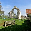 Reach, remains of the mediaeval church - geograph.org.uk - 6124051.jpg 1,024 × 1,024; 1.3 MB
-
 Reach, Spring Hall - geograph.org.uk - 2753482.jpg 1,024 × 707; 951 KB
-
 Reach, swings on Fair Green - geograph.org.uk - 6124049.jpg 1,024 × 731; 872 KB
-
 Reach, the corner of Chapel Lane - geograph.org.uk - 2753600.jpg 1,024 × 768; 879 KB
-
 Reach, the end of the lode - geograph.org.uk - 2753586.jpg 1,024 × 768; 1.16 MB
-
 Reach, top of the earthworks - geograph.org.uk - 2825911.jpg 1,600 × 1,067; 622 KB
-
 Reach, White Roses - geograph.org.uk - 6124364.jpg 1,024 × 1,024; 1.49 MB
-
 Reach, white walls and a blue sky - geograph.org.uk - 6124047.jpg 1,024 × 682; 796 KB
-
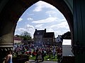
 Reach,Cambridgeshire Reach Fair 2009.jpg 1,024 × 512; 112 KB
-
 Reeds reflected in Reach Lode - geograph.org.uk - 6124163.jpg 1,024 × 768; 969 KB
-
 Road from Reach into the Fens - geograph.org.uk - 1461942.jpg 640 × 480; 97 KB
-

-
 Row of cottages - geograph.org.uk - 6047479.jpg 1,024 × 681; 146 KB
-
 Row of Cottages, Swaffham Rd - geograph.org.uk - 6047468.jpg 1,024 × 681; 144 KB
-
 Sheep grazing near Reach Lode - geograph.org.uk - 6124158.jpg 1,024 × 768; 940 KB
-
 Sign for the Dyke's End, Reach - geograph.org.uk - 4702042.jpg 488 × 640; 66 KB
-

-
 Snakehall Farm - geograph.org.uk - 6047452.jpg 1,024 × 681; 108 KB
-
 Spring Hall - geograph.org.uk - 6055445.jpg 1,024 × 681; 224 KB
-
 Spring Hall - geograph.org.uk - 6055449.jpg 1,024 × 681; 130 KB
-

-

-

-
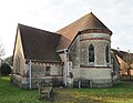 St Etheldreda ^ Holy Trinity, Reach - geograph.org.uk - 5288805.jpg 900 × 696; 521 KB
-
 St Etheldreda ^ Holy Trinity, Reach - geograph.org.uk - 5288808.jpg 900 × 750; 669 KB
-
 St Etheldreda ^ Holy Trinity, Reach - geograph.org.uk - 5288809.jpg 580 × 900; 498 KB
-
 St Etheldreda ^ Holy Trinity, Reach - geograph.org.uk - 5288811.jpg 900 × 821; 733 KB
-
 St Etheldreda ^ Holy Trinity, Reach - geograph.org.uk - 5288814.jpg 900 × 675; 616 KB
-

-


_-_geograph.org.uk_-_1192995.jpg)


.png)


