Category:Renfrew
Перейти до навігації
Перейти до пошуку
town in Renfrewshire, Scotland, UK  | |||||
| Завантажити медіафайл | |||||
| Є одним із |
| ||||
|---|---|---|---|---|---|
| Місце розташування |
| ||||
| Кількість населення |
| ||||
| Висота над рівнем моря |
| ||||
| Не плутати з | |||||
 | |||||
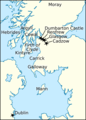
English: Renfrew (Rinn Friù in Scottish Gaelic) is a town, located west of Glasgow in the West Central Lowlands of Scotland. Traditionally, Renfrew is the county town of Renfrewshire (also known as the County of Renfrew), a unit of local government used until the reorganisation of 1975. The name Renfrewshire survives in local government in the names of the modern council areas of Renfrewshire and East Renfrewshire. In 1164, Somerled, Lord of the Isles sailed to Renfrew and attacked Clan Stewart, known as the Battle of Renfrew. The outcome was a defeat of the Lord of the Isles and the death of Somerled. The town is located at the confluence of the River Clyde and the River Cart. A passenger ferry crosses the Clyde to Yoker and a bascule bridge crosses the Cart to Inchinnan and Glasgow International Airport.
Español: Renfrew (Rinn Friù en gaélico escocés) es un pueblo, ubicado seis millas al oeste de Glasgow en la costa occidental de Escocia. Fue la capital del condado tradicional de Renfrewshire hasta 1975. Desde ese año hasta 1996, se encontraba situado en el distrito de Renfrew, en la región del gobierno local de Strathclyde. En la actualidad, se sitúa en la zona gubernamental unitaria de Renfrewshire.
Français : Renfrew (en gaélique écossais Rinn Friù) est un bourg d'Écosse, situé à l'ouest de Glasgow, sur la côte occidentale écossaise.
Nederlands: Renfrew ( Schots-Gaelisch: Rinn Friù) is een town in de Schotse council Renfrewshire in het historisch graafschap Renfrewshire en ligt ongeveer 10 kilometer ten westen van Glasgow. Renfrew was tot 1975 de hoofdplaats van het graafschap Renfrewshire vandaar ook de naam van de stad.
Polski: Renfrew ( szkoc. gael. Rinn Friù) to miasto w zachodniej części Szkocji nad rzeką Clyde. Około 9.7 km na zachód od Glasgow.
Підкатегорії
Показано 23 підкатегорії з 23.
A
- Argyll Stone (10 F)
B
- Blythswood House (3 F)
F
- Ferry Village, Renfrew (8 F)
K
L
N
- Normandy Hotel, Renfrew (6 F)
P
R
- Renfrew Mills (3 F)
- Renfrew scrapyard fire 2008 (6 F)
- Robertson Park, Renfrew (8 F)
S
T
- The Abbot's Inch (2 F)
- The Regal, Renfrew (2 F)
- Renfrew Town Hall (6 F)
V
- Victory Baths, Renfrew (3 F)
W
- Renfrew War Memorial (2 F)
- Westway, Renfrew (2 F)
- White Cart Bridge, Inchinnan (42 F)
Файли в категорії «Renfrew»
Показано 100 файлів цієї категорії (із 100).
-

-
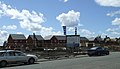 Ainslie Square - geograph.org.uk - 859873.jpg 640 × 370; 64 КБ
-
 Anchor of the MV Shoalway - geograph.org.uk - 2455782.jpg 640 × 480; 34 КБ
-
 Audi HQ, Glasgow - geograph.org.uk - 527040.jpg 640 × 480; 66 КБ
-
 BAE Scotstoun shipyard - geograph.org.uk - 2069253.jpg 640 × 319; 66 КБ
-
 BAE Scotstoun shipyard - geograph.org.uk - 2069262.jpg 640 × 480; 109 КБ
-
 BAE Scotstoun shipyard - geograph.org.uk - 2069281.jpg 480 × 640; 121 КБ
-
 BAE Scotstoun Shipyard - geograph.org.uk - 2650285.jpg 640 × 480; 106 КБ
-
 BAE Systems Scotstoun shipyard - geograph.org.uk - 3638639.jpg 640 × 480; 106 КБ
-
 BAE Systems Scotstoun shipyard - geograph.org.uk - 3638642.jpg 640 × 480; 88 КБ
-
 BAE Systems Scotstoun shipyard - geograph.org.uk - 3646653.jpg 640 × 480; 105 КБ
-
 Battle of Renfrew.png 810 × 1127; 244 КБ
-
 Boardwalk at Braehead - geograph.org.uk - 2348907.jpg 640 × 480; 70 КБ
-
 Braehead pontoon - geograph.org.uk - 2389297.jpg 480 × 640; 120 КБ
-
 Braehead pontoon - geograph.org.uk - 3646661.jpg 640 × 480; 101 КБ
-
 Braehead pontoon - geograph.org.uk - 3646693.jpg 640 × 480; 108 КБ
-
 Braehead rear view - geograph.org.uk - 2348922.jpg 640 × 480; 65 КБ
-
 Braehead shopping centre - geograph.org.uk - 2389312.jpg 640 × 480; 129 КБ
-
 Braehead shopping centre - geograph.org.uk - 3450887.jpg 2210 × 1265; 2,12 МБ
-
 Brown Institute, Renfrew - geograph.org.uk - 1629400.jpg 640 × 480; 97 КБ
-
 Brown Street - geograph.org.uk - 859897.jpg 640 × 480; 96 КБ
-
 Brown Street - geograph.org.uk - 859929.jpg 640 × 480; 94 КБ
-
 Canal Street, Renfrew - geograph.org.uk - 1629319.jpg 640 × 480; 79 КБ
-
 Canal Street, Renfrew - geograph.org.uk - 483135.jpg 640 × 480; 69 КБ
-
 Clydebuilt Maritime Museum - geograph.org.uk - 2069245.jpg 640 × 480; 129 КБ
-
 Confluence of the Black Cart and White Cart Waters - geograph.org.uk - 4533022.jpg 3264 × 2448; 4,09 МБ
-
 Cotton's Bar, Renfrew - geograph.org.uk - 482924.jpg 640 × 480; 57 КБ
-
 Craigielea Road - geograph.org.uk - 859950.jpg 640 × 480; 99 КБ
-
 Cross Keys - geograph.org.uk - 859860.jpg 640 × 423; 94 КБ
-
 CSC stone - geograph.org.uk - 859938.jpg 640 × 387; 74 КБ
-
 D35 and D36 at Scotstoun shipyard - geograph.org.uk - 2349527.jpg 640 × 480; 112 КБ
-
 Diageo whisky warehouse Govan Road - geograph.org.uk - 1495326.jpg 640 × 480; 68 КБ
-
 Distant view of Clydebank Titan crane - geograph.org.uk - 2460093.jpg 1024 × 768; 126 КБ
-

-

-

-

-

-

-

-

-

-

-
 Electrical Sub-Station, Renfrew - geograph.org.uk - 1629378.jpg 640 × 480; 96 КБ
-
 Fulbar Avenue - geograph.org.uk - 860034.jpg 640 × 480; 112 КБ
-
 Garden, 42 Ferguson Avenue - geograph.org.uk - 531116.jpg 1770 × 1195; 312 КБ
-
 Grade-school-Renfrew.jpg 640 × 480; 140 КБ
-
 Hammerhead crane at Barclay, Curle ^ Co - geograph.org.uk - 2460115.jpg 1024 × 768; 127 КБ
-
 HMS Defender - geograph.org.uk - 2905818.jpg 1100 × 729; 442 КБ
-
 HMS Defender at Scotstoun - geograph.org.uk - 2455657.jpg 1024 × 768; 159 КБ
-
 Houses on Royal Inch Terrace - geograph.org.uk - 938042.jpg 640 × 480; 108 КБ
-
 Icy Road, Renfrew - geograph.org.uk - 1629383.jpg 640 × 480; 91 КБ
-
 Im1871EnV31-p372.jpg 760 × 597; 84 КБ
-
 Inchinnan Road - geograph.org.uk - 860080.jpg 640 × 480; 97 КБ
-
 Junction 27 of theM8 - geograph.org.uk - 518619.jpg 640 × 480; 60 КБ
-
 Ladbrokes, Renfrew - geograph.org.uk - 483139.jpg 640 × 480; 80 КБ
-
 Map of Renfrewshire Sheet 008, Ordnance Survey, 1863-1864.jpg 10 709 × 7168; 9,19 МБ
-
 Map of Renfrewshire Sheet 008, Ordnance Survey, 1863-1864.tiff 10 709 × 7168; 219,62 МБ
-
 McClue Road - geograph.org.uk - 860068.jpg 640 × 480; 93 КБ
-
 Moorpark Primary School - geograph.org.uk - 859883.jpg 640 × 480; 107 КБ
-
 MV Bekau loading at Whiteinch - geograph.org.uk - 2460119.jpg 1024 × 768; 176 КБ
-
 MV Shoalway approaching Braehead - geograph.org.uk - 2455773.jpg 1024 × 768; 160 КБ
-
 P50806-193444-001.jpg 3936 × 5248; 9,87 МБ
-
 Paisley Road, Renfrew - geograph.org.uk - 518616.jpg 640 × 480; 58 КБ
-
 Path to the White Cart Water (geograph 5929210).jpg 1600 × 889; 235 КБ
-
 Rannoch Drive - geograph.org.uk - 860027.jpg 640 × 480; 102 КБ
-
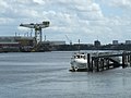
 Renfrew Ferry (geograph 2354536).jpg 640 × 480; 111 КБ
-
 Renfrew Fire Station - geograph.org.uk - 859853.jpg 640 × 480; 84 КБ
-
 Renfrew Football Club - geograph.org.uk - 860004.jpg 640 × 437; 81 КБ
-
 Renfrew from the air (geograph 6125158).jpg 992 × 1024; 415 КБ
-
 Renfrew High School - geograph.org.uk - 18642.jpg 640 × 480; 87 КБ
-
 Renfrew Police Station - geograph.org.uk - 859989.jpg 640 × 600; 125 КБ
-
 Renfrew South and Gallowhill.svg 1425 × 1168; 957 КБ
-
 Renfrewcommunitypanorama.jpg 7019 × 907; 509 КБ
-
 River Clyde at Scotstoun - geograph.org.uk - 2349021.jpg 640 × 480; 71 КБ
-
 River Clyde from Braehead car park - geograph.org.uk - 2950266.jpg 640 × 480; 84 КБ
-
 River Clyde west of Glasgow.jpg 2848 × 2136; 2,15 МБ
-
 Roadworks at Inchinnan Road, Renfrew - geograph.org.uk - 483141.jpg 640 × 480; 71 КБ
-
 Sandy Road, Renfrew - geograph.org.uk - 518606.jpg 640 × 480; 48 КБ
-
 Scarborough CG51 - geograph.org.uk - 2069269.jpg 640 × 480; 119 КБ
-
 Seaplane over Scotstoun - geograph.org.uk - 2069280.jpg 566 × 640; 70 КБ
-
 Seatrek Training vessel at Braehead - geograph.org.uk - 3646764.jpg 640 × 372; 114 КБ
-
 Seatrek Training vessel at Braehead - geograph.org.uk - 3646767.jpg 640 × 392; 107 КБ
-
 Shieldhall Whisky Bottling Plant - geograph.org.uk - 59318.jpg 640 × 480; 125 КБ
-
 Shop on Porterfield Road - geograph.org.uk - 859866.jpg 640 × 398; 77 КБ
-
 Swans at Scoustoun - geograph.org.uk - 2069258.jpg 640 × 404; 138 КБ
-
 The Clyde from Braehead - geograph.org.uk - 2389224.jpg 800 × 360; 115 КБ
-
 The Clyde from Braehead - geograph.org.uk - 2389239.jpg 640 × 480; 98 КБ
-
 The Glynhill Hotel - geograph.org.uk - 119407.jpg 640 × 457; 67 КБ
-
 The River Clyde at Renfrew (geograph 6125173).jpg 1024 × 640; 292 КБ
-
 The River Clyde at Renfrew - geograph.org.uk - 3987865.jpg 3264 × 2448; 3,64 МБ
-
 The Upper Clyde and Kilpatrick Hills - geograph.org.uk - 2069289.jpg 640 × 382; 77 КБ
-
 Traffic lights - geograph.org.uk - 518613.jpg 640 × 480; 50 КБ
-
 Utility Vessel St Mungo near Braehead - geograph.org.uk - 2460055.jpg 1024 × 768; 154 КБ
-
 View downriver - geograph.org.uk - 2348944.jpg 640 × 480; 47 КБ
-
 Water fountain - geograph.org.uk - 818238.jpg 480 × 640; 101 КБ
-
 Welcome to Renfrewshire - geograph.org.uk - 2926951.jpg 3264 × 2448; 2,79 МБ
-
 White Cart River Near Glasgow Airport - panoramio.jpg 3072 × 2304; 3,21 МБ
-
 Wright Street, Renfrew - geograph.org.uk - 1382950.jpg 640 × 480; 76 КБ
-
 Yasa Unsal Sunar - geograph.org.uk - 3450850.jpg 2220 × 1250; 3,01 МБ
.jpg)


.jpg)

.jpg)


.jpg)


.jpg)


