Category:Rhodter Straße 5 (Edenkoben)
Jump to navigation
Jump to search
This is the category for a cultural monument.
It is on the list of cultural monuments of Edenkoben. |
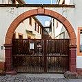
Rhodter Straße 5, residential building
- Allegedly former synagogue, arch designated 1754
| Object location | | View all coordinates using: OpenStreetMap |
|---|
Media in category "Rhodter Straße 5 (Edenkoben)"
The following 3 files are in this category, out of 3 total.
-
 Edenkoben Rhodter Straße 5 001 2017 02 15.jpg 1,920 × 2,602; 1.89 MB
-
 Edenkoben Rhodter Straße 5 002 2017 02 15.jpg 2,223 × 2,248; 2.57 MB
-
 Edenkoben Rhodter Straße 5 003 2017 02 15.jpg 2,190 × 2,283; 2.06 MB


