Category:Rijksweg 4
Aller à la navigation
Aller à la recherche
autoroute néerlandaise    | |||||
| Téléverser des médias | |||||
| Nature de l’élément |
| ||||
|---|---|---|---|---|---|
| Lieu | |||||
| Réseau de transport |
| ||||
| Maintenance assurée par | |||||
| Date de fondation ou de création |
| ||||
| Longueur |
| ||||
| Extrémité | |||||
| À ne pas confondre avec | |||||
| Coïncide partiellement avec |
| ||||
 | |||||
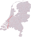
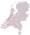
Nederlands: Rijksweg 4 (A4) is een Nederlandse rijks- en autosnelweg door de provincies Noord-Holland, Zuid-Holland en Noord-Brabant, welke loopt van Amsterdam naar de Belgische grens en op drie plaatsen is onderbroken. Tussen Klaaswaal en Dinteloord is de weg bewegwijzerd als A29, op de overige stukken als A4. Zie ook: category:Rijksweg 29.
English: Rijksweg 4 (A4) is a Dutch motorway through the provinces of North Holland, South Holland, and North Brabant, which runs from Amsterdam to the Belgian border and which is interrupted at three locations. From Klaaswaal to Dinteloord the motorway is signed as A29, on other parts it is signed as A4. See also: category:Rijksweg 29.
Sous-catégories
Cette catégorie comprend 3 sous-catégories, dont les 3 ci-dessous.
N
S
Média dans la catégorie « Rijksweg 4 »
Cette catégorie comprend 21 fichiers, dont les 21 ci-dessous.
-

-

-
 Another day in paradise III - Flickr - rhodes.jpg 3 008 × 2 000 ; 1,15 Mio
-
 AROUND LEIDEN,2010 (1) (8161377967).jpg 4 004 × 2 668 ; 1,56 Mio
-
 AROUND LEIDEN,2010 (2) (8161406578).jpg 3 913 × 1 968 ; 999 kio
-
 AROUND LEIDEN,2010 (3) (8161403196).jpg 4 368 × 2 912 ; 1,68 Mio
-
 AROUND LEIDEN,2010 (4) (8161399424).jpg 4 368 × 2 912 ; 1,65 Mio
-
 AROUND LEIDEN,2010 (5) (8161362473).jpg 4 368 × 2 912 ; 1,62 Mio
-
 Bobbiedenwebcamsex.jpg 1 024 × 768 ; 205 kio
-
 Bobbiedenwebcamsexnlbillboard.jpg 1 400 × 1 050 ; 372 kio
-
Eerste Nederlandse Autostrada-508135.ogv 47 s, 768 × 576 ; 8,49 Mio
-
 Hectometerpaal.jpg 124 × 79 ; 3 kio
-

-

-

-
 NL-A4.png 492 × 288 ; 9 kio
-
 NL-A4.svg 411 × 253 ; 3 kio
-
 Rijksweg4 A4-A29.svg 770 × 908 ; 248 kio
-
 Rijksweg4.svg 801 × 924 ; 958 kio
-
 Sentosa Impex.JPG 2 669 × 1 997 ; 1,08 Mio
-
 Weiland ten oosten van Kasteel Ruwiel, Oud-Aa, met A2 - October 2022.jpg 2 272 × 1 704 ; 1,71 Mio


_(8161377967).jpg)
_(8161406578).jpg)
_(8161403196).jpg)
_(8161399424).jpg)
_(8161362473).jpg)


