Category:Ringstead, Dorset
Jump to navigation
Jump to search
coastal village in Dorset, England, United Kingdom    | |||||
| Upload media | |||||
| Instance of | |||||
|---|---|---|---|---|---|
| Location |
| ||||
| Located in or next to body of water | |||||
 | |||||
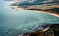
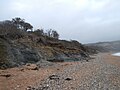
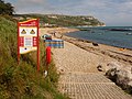
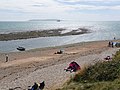
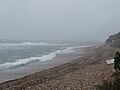
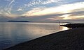
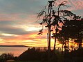
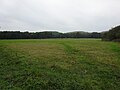
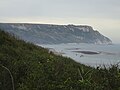
English: Ringstead is a small village with a pebble and shingle beach on the English Channel coast in Dorset, England. Ringstead Bay has shingle and some sand, with offshore reefs approximately 600 metres in length at the western end becoming uncovered at low tide. It forms the intertidal zone between the high cliffs and fields heading northwards and the English Channel to the south.
Media in category "Ringstead, Dorset"
The following 99 files are in this category, out of 99 total.
-
 An unusual rock.jpg 4,608 × 3,456; 3.56 MB
-
 Another nice sunset.jpg 4,608 × 3,456; 3.63 MB
-
 Beach cafe, Ringstead - geograph.org.uk - 3048777.jpg 640 × 480; 71 KB
-
 Boat on Ringstead Beach - geograph.org.uk - 919132.jpg 640 × 426; 127 KB
-
 Books of Dorset.jpg 1,936 × 2,592; 1.41 MB
-
 Bridge on the footpath from Ringstead to Osmington Mills - DSC08983.jpg 3,672 × 4,896; 7.41 MB
-
 Cattle above Ringstead - geograph.org.uk - 266597.jpg 640 × 480; 96 KB
-

-

-
 Cottages in the village of Ringstead, Dorset - DSC08963.jpg 4,896 × 3,672; 5.55 MB
-
 Cruise ships in Weymouth Bay from above Ringstead - DSC08880.jpg 4,912 × 1,080; 1 MB
-
 Different sunset.jpg 2,049 × 1,537; 397 KB
-
 DZCL7358.jpg 2,592 × 1,944; 1.6 MB
-
 Falcon Barn - geograph.org.uk - 266595.jpg 640 × 480; 109 KB
-
 Flooded Beach - geograph.org.uk - 6176590.jpg 4,608 × 3,456; 3.61 MB
-
 Hazy Weymouth Bay - geograph.org.uk - 3562657.jpg 3,072 × 2,304; 2.31 MB
-
 Holworth Farm House - geograph.org.uk - 425930.jpg 640 × 427; 126 KB
-
 Holworth House and Ringstead - geograph.org.uk - 266717.jpg 640 × 480; 96 KB
-

-
 Holworth, postbox № DT2 114 - geograph.org.uk - 1887769.jpg 640 × 480; 133 KB
-
 Holworth, the path from Ringstead - geograph.org.uk - 1415639.jpg 640 × 480; 73 KB
-
 Holworth, view towards the west - geograph.org.uk - 1416583.jpg 640 × 482; 64 KB
-
 House by the Coast Path - geograph.org.uk - 2534313.jpg 1,024 × 768; 254 KB
-
 My home's spider.jpg 2,448 × 3,264; 398 KB
-
 Nice Chevy in Ringstead.jpg 3,264 × 2,448; 2.7 MB
-
 Not a sunrise.jpg 4,608 × 3,456; 3.25 MB
-
 Obey Portland.jpg 2,049 × 1,537; 328 KB
-
 Ringstead Bay - geograph.org.uk - 1564861.jpg 640 × 427; 65 KB
-
 Ringstead Bay and the village of Ringstead - DSC08886.jpg 3,672 × 4,896; 5.3 MB
-
 Ringstead Bay c.1970.jpg 1,024 × 621; 1.08 MB
-
 Ringstead Bay from the path to White Nothe - DSC08931.jpg 4,896 × 3,672; 4.25 MB
-
 Ringstead Bay from the path to White Nothe - DSC08934.jpg 3,672 × 4,896; 4.75 MB
-
 Ringstead Bay with Weymouth Bay in the distance - DSC08883.jpg 4,896 × 3,672; 4.82 MB
-
 Ringstead beach - DSC08873.jpg 4,896 × 3,672; 5.84 MB
-
 Ringstead Beach - geograph.org.uk - 6176284.jpg 4,608 × 3,456; 3.69 MB
-
 Ringstead Beach - geograph.org.uk - 6176312.jpg 4,608 × 3,456; 3.66 MB
-
 Ringstead beach - geograph.org.uk - 919107.jpg 640 × 426; 78 KB
-
 Ringstead Beach - geograph.org.uk - 919108.jpg 640 × 426; 94 KB
-
 Ringstead beach and reef with White Nothe in the distance - DSC08976.jpg 4,896 × 3,672; 5.05 MB
-
 Ringstead Beach at sunset.jpg 4,608 × 3,456; 3.57 MB
-
 Ringstead Beach August 2016.jpg 2,560 × 1,536; 1.53 MB
-
 Ringstead Beach during a storm.jpg 4,608 × 3,456; 3.54 MB
-
 Ringstead beach from the path to White Nothe - DSC08881.jpg 4,896 × 3,672; 5.78 MB
-
 Ringstead beach September 2015.jpg 4,608 × 3,456; 3.83 MB
-
 Ringstead Beach up to cliffs.jpg 4,608 × 3,456; 3.58 MB
-
 Ringstead beach, reef, and cruise ships - DSC08975.jpg 4,896 × 3,672; 5.26 MB
-
 Ringstead beach, reef, and cruise ships - DSC08978.jpg 4,896 × 3,672; 6.42 MB
-
 Ringstead Beach.jpg 4,608 × 3,456; 3.69 MB
-
 Ringstead beach.jpg 1,803 × 2,404; 1.06 MB
-
 Ringstead Cliffs - geograph.org.uk - 6176306.jpg 4,608 × 3,456; 3.81 MB
-
 Ringstead Cliffs.jpg 4,608 × 3,456; 3.72 MB
-
 Ringstead ledge - geograph.org.uk - 3048790.jpg 640 × 480; 96 KB
-
 Ringstead ledge - geograph.org.uk - 3048842.jpg 640 × 480; 52 KB
-
 Ringstead Sunset.jpg 2,560 × 1,536; 1.24 MB
-
 Ringstead village and beach, Dorset, England - DSC08887.jpg 4,896 × 3,672; 5.69 MB
-
 Ringstead village from the path to White Nothe - DSC08935.jpg 4,896 × 3,672; 4.76 MB
-
 Ringstead village from the path to White Nothe - DSC08936.jpg 4,896 × 3,672; 5.02 MB
-
 Ringstead village from the path to White Nothe - DSC08937.jpg 4,896 × 3,672; 4.92 MB
-
 Ringstead with Weymouth in the distance - DSC08874.jpg 4,896 × 3,672; 4.47 MB
-
 Ringstead's rough tide - geograph.org.uk - 6176339.jpg 4,608 × 3,456; 3.55 MB
-
 Ringstead, beach notices - geograph.org.uk - 1416605.jpg 640 × 480; 104 KB
-
 Ringstead, Dorset.jpg 2,592 × 1,936; 1.84 MB
-
-
 Ringstead, sheep on South Down - geograph.org.uk - 1415617.jpg 640 × 480; 71 KB
-

-
 Ringstead, the road down - geograph.org.uk - 1416612.jpg 640 × 480; 60 KB
-

-
 Ringstead.jpg 4,608 × 3,456; 3.63 MB
-
 Rocks at Ringstead.jpg 4,608 × 3,456; 3.67 MB
-
 Rough sea at Ringstead.jpg 4,608 × 3,456; 3.66 MB
-
 Shingle beach west of Ringstead - geograph.org.uk - 3075643.jpg 4,752 × 3,168; 4.08 MB
-
 South Down - geograph.org.uk - 848925.jpg 640 × 480; 115 KB
-
 South Down near Ringstead Bay - geograph.org.uk - 1762076.jpg 800 × 466; 401 KB
-
 South Down, Dorset - geograph.org.uk - 1715700.jpg 640 × 379; 50 KB
-
 Stone sign for Osmington Mills on the South West Coast Path - DSC08989.jpg 4,896 × 3,672; 6.89 MB
-
 Stormy Ringstead.jpg 4,608 × 3,456; 3.41 MB
-
 Sunrise at Ringstead.jpg 4,608 × 3,456; 3.27 MB
-
 Sunset at Ringstead.jpg 2,560 × 1,536; 1.24 MB
-
 Sunset land!.jpg 4,608 × 3,456; 3.39 MB
-
 Sunset over Ringstead.jpg 3,264 × 2,448; 1.57 MB
-
 Sunset Ringstead.jpg 2,592 × 1,936; 1 MB
-
 The beach at Ringstead Bay - geograph.org.uk - 3075635.jpg 4,752 × 3,168; 3.44 MB
-
 The coast path near Burning Cliff - geograph.org.uk - 2990783.jpg 1,024 × 768; 316 KB
-

-
 Toll road away from Ringstead beach - geograph.org.uk - 266912.jpg 640 × 480; 79 KB
-

-
 View out of Ringstead.jpg 2,592 × 1,936; 1.38 MB
-
 Walking in Ringstead.jpg 3,264 × 2,448; 2.19 MB
-
 West Ringstead deserted medieval village, Dorset - DSC08985.jpg 4,896 × 3,672; 5.25 MB
-
 West Ringstead deserted medieval village, Dorset - DSC08986.jpg 4,896 × 3,672; 4.47 MB
-
 Weymouth Bay from Ringstead (50187420596).jpg 4,896 × 2,354; 1.73 MB
-
 Weymouth Bay from White Nothe - geograph.org.uk - 5163066.jpg 5,104 × 3,348; 2.66 MB
-
 White Nothe and Ringstead path sign - DSC08878.jpg 4,896 × 3,672; 7.8 MB
-
 White Nothe from the South West Coast Path, Dorset - DSC09005.jpg 4,896 × 3,672; 4.76 MB
-
 White Nothe in the distance from the South West Coast Path, Dorset - DSC09008.jpg 4,896 × 3,672; 6.06 MB
-
 Xboxrocker84 - Ringstead - Sunset.jpg 3,264 × 2,448; 1.55 MB
-
 Cows near South Down Farm, Ringstead - geograph.org.uk - 266958.jpg 640 × 480; 106 KB
-
 Stile on South Down, Ringstead - geograph.org.uk - 266965.jpg 480 × 640; 112 KB
-


.jpg)


