Category:Ruhpolding
Salti al navigilo
Salti al serĉilo
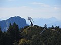
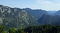
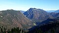
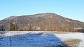
komunumo en Bavario, Germanio  Ruhpolding văzut de pe muntele Unterberg    | |||||
| Alŝuti plurmedion | |||||
| Estas |
| ||||
|---|---|---|---|---|---|
| Parto de |
| ||||
| Loko | distrikto Traunstein, Supra Bavario, Bavario, Germanio | ||||
| Estro |
| ||||
| Loĝantaro |
| ||||
| Areo |
| ||||
| Supermara alteco |
| ||||
| oficiala retejo | |||||
 | |||||
Subkategorioj
Ĉi tiu kategorio havas la 10 jenajn subkategoriojn, el 10 entute.
B
C
E
G
M
P
R
S
T
Dosieroj en kategorio “Ruhpolding”
La jenaj 77 dosieroj estas en ĉi tiu kategorio, el 77 entute.
-
 04.08.2016. -Brand,83324 Ruhpolding, Deutschland - panoramio - Sandor Bordas (1).jpg 4 320 × 3 240; 4,97 MB
-
 140810-Schiffswerft-G-12.jpg 2 400 × 1 600; 2,01 MB
-
 83324 Ruhpolding, Germany - panoramio (2).jpg 1 568 × 2 352; 1,66 MB
-
 Abzweigung bei Maiergschwendt - geo.hlipp.de - 25499.jpg 640 × 480; 76 KB
-
 AK - Ruhpolding mit Sonntagshorn - 1928.jpg 1 461 × 1 143; 1,75 MB
-
 Angerer der Juengere - Adams Hand.jpg 4 000 × 3 000; 2,14 MB
-
 AnticlineWettersteinkalk.jpg 4 000 × 3 000; 2,56 MB
-
 Bauernhaus bei Ruhpolding - geo.hlipp.de - 21274.jpg 640 × 480; 87 KB
-
 Bauernhäuser aus Oberbayern und angr Gebieten Tirols (1900) - 0052.jpg 2 170 × 3 000; 1,29 MB
-
 Bischofsfelln.jpg 2 322 × 4 128; 3,87 MB
-
 Brand- Bauernhof - geo.hlipp.de - 21165.jpg 640 × 480; 45 KB
-
 DEU Ruhpolding COA.svg 992 × 1 091; 23 KB
-
 EisenbergM.jpg 3 000 × 4 000; 2,55 MB
-
 EisenbergS.jpg 4 128 × 2 322; 2,54 MB
-
 FroschseeRuhpolding.jpg 4 128 × 2 322; 4,57 MB
-
 FroschseeRuhpolding2.jpg 4 128 × 2 322; 5,12 MB
-
 FroschseeRuhpolding3.jpg 4 128 × 2 322; 3,35 MB
-
 FroschseeRuhpolding4.jpg 4 128 × 2 322; 4,44 MB
-
 FroschseeRuhpolding5.jpg 4 128 × 2 322; 4,09 MB
-
 Gurnwandkopf.png 826 × 631; 828 KB
-
 Gurnwandkopf2.png 826 × 628; 869 KB
-
 HGK1.jpg 2 322 × 4 128; 5,13 MB
-
 HGK2.jpg 2 322 × 4 128; 5,2 MB
-
 HGK3.jpg 4 128 × 2 322; 3,74 MB
-
 HGK4.jpg 4 128 × 2 322; 5,5 MB
-
 HGK5.jpg 4 128 × 2 322; 3 MB
-
 HGK6.jpg 4 128 × 2 322; 4,71 MB
-
 HGK7.jpg 4 128 × 2 322; 2,5 MB
-
 HGK8.jpg 4 128 × 2 322; 4,75 MB
-
 Hochscharten.png 822 × 616; 772 KB
-
 Holzknechtalm.jpg 3 791 × 2 843; 4,17 MB
-
 Kaitlalm - Panoramaansicht.jpg 3 104 × 1 801; 1,54 MB
-
 Kaitlalm Ruhpolding, Wirtschaftsgebäude, November 2020.jpg 4 032 × 3 024; 4,89 MB
-
 KienberglCor2.JPG 4 000 × 3 000; 2,54 MB
-

-
 ND Hoch-und Übergangsmoor östlich Gstatt Amtsblatt.jpg 809 × 1 133; 414 KB
-
-
 RauschbergProf.png 1 346 × 542; 208 KB
-
 ReiherUA.jpg 4 000 × 3 000; 2,61 MB
-
-
 Ruhpolding in TS.svg 652 × 820; 1,35 MB
-
 Ruhpolding Johanneskirche u. St. Valentin 499.jpg 4 896 × 3 264; 14,46 MB
-
 RUHPOLDING nieder.png 480 × 360; 5 KB
-
 RUHPOLDING nieder.svg 512 × 427; 21 KB
-
 RUHPOLDING SEEHAUS nieder.png 480 × 360; 5 KB
-
 RUHPOLDING SEEHAUS nieder.svg 512 × 427; 21 KB
-

-
 Ruhpolding- Der Westernberg-Skilift - geo.hlipp.de - 24110.jpg 458 × 640; 52 KB
-
 Ruhpolding- Skiabfahrt am Westernberg - geo.hlipp.de - 24112.jpg 640 × 480; 73 KB
-
 Ruhpolding- Talstation der Rauschbergbahn - geo.hlipp.de - 21170.jpg 640 × 480; 85 KB
-
 Röthelmoosalm.jpg 4 032 × 3 024; 2,74 MB
-
 Schneid1.jpg 4 128 × 2 322; 6,72 MB
-
 Schneid2.jpg 4 128 × 2 322; 6,2 MB
-
 Schneid3.jpg 4 128 × 2 322; 4,11 MB
-
 Schneid4.jpg 4 128 × 2 322; 2,41 MB
-
 Schneid5.jpg 4 128 × 2 322; 2,64 MB
-
 Schneid6.jpg 4 128 × 2 322; 2,8 MB
-
 Schneid7.jpg 2 322 × 4 128; 6,1 MB
-
 Schneid8.jpg 4 128 × 2 322; 2,52 MB
-
 Schneid9.jpg 2 322 × 4 128; 5 MB
-
 SchneidSchutt.jpg 2 322 × 4 128; 4,8 MB
-
 SeekopfAndi.jpg 4 000 × 3 000; 2,69 MB
-
 SeekopfWest.jpg 3 000 × 4 000; 2,73 MB
-
 StreicherRUH.JPG 4 000 × 3 000; 2,57 MB
-
 TaubenseeRuhpolding.jpg 4 128 × 2 322; 3,54 MB
-
 TaubenseeRuhpolding2.jpg 4 128 × 2 322; 5,24 MB
-
 UrschlauerAchen.jpg 4 000 × 3 000; 2,57 MB
-
 UrschlauerAchenW.jpg 4 000 × 3 000; 2,56 MB
-
 Wappen ruhpolding.gif 450 × 526; 18 KB
-
 WesterbergZ.jpg 4 128 × 2 322; 3,55 MB
-
 ZellerbergBrand.jpg 4 128 × 2 322; 2,91 MB
-
 ZellerbergGipfel.jpg 4 128 × 2 322; 4,53 MB
-
 ZellerbergKreuz.jpg 2 322 × 4 128; 6,23 MB
-
 ZellerbergNW.jpg 4 128 × 2 322; 5,08 MB
-
 ZellerbergSW.jpg 4 128 × 2 322; 4,51 MB
-
 Zufahrtsbeschränkung bei Laubau.jpg 3 864 × 3 000; 2,15 MB
-
 Тостозадый козел - panoramio.jpg 1 200 × 900; 632 KB
.jpg)

.jpg)


_-_0052.jpg)


