Category:Rusland 20, Amsterdam
Jump to navigation
Jump to search
| Object location | | View all coordinates using: OpenStreetMap |
|---|
building in Amsterdam, Netherlands  | |||||
| Upload media | |||||
| Instance of | |||||
|---|---|---|---|---|---|
| Location | Amsterdam, North Holland, Netherlands | ||||
| Street address |
| ||||
| Located on street | |||||
| Heritage designation |
| ||||
 | |||||
|
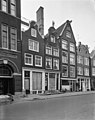
This is a category about rijksmonument number 5137
|
| Address |
|
Media in category "Rusland 20, Amsterdam"
The following 3 files are in this category, out of 3 total.
-
 Eind, overczicht - Amsterdam - 20020747 - RCE.jpg 807 × 1,200; 175 KB
-
 Voorgevels - Amsterdam - 20020744 - RCE.jpg 946 × 1,200; 228 KB
-
 Voorgevels - Amsterdam - 20020748 - RCE.jpg 948 × 1,200; 200 KB

