Category:Rutteler Mühle
Jump to navigation
Jump to search
| Object location | | View all coordinates using: OpenStreetMap |
|---|
 | |||||
| Upload media | |||||
| Instance of | |||||
|---|---|---|---|---|---|
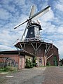
| Location | Zetel, Friesland (district), Lower Saxony, Germany | ||||
| Heritage designation | |||||
 | |||||
Media in category "Rutteler Mühle"
The following 2 files are in this category, out of 2 total.
-
 Rutteler Muehle.jpg 1,536 × 2,048; 1.68 MB
-
 Rutteler Mühle.jpg 1,602 × 1,008; 723 KB
