Category:Saint Anne church in Suchy Dąb
Jump to navigation
Jump to search
| Object location | | View all coordinates using: OpenStreetMap |
|---|
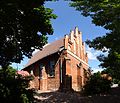
Polski: Suchy Dąb - rzymskokatolicki kościół parafialny p.w. św. Anny (dec. ruina), XIV, 1732, 1978.
church building in Suchy Dąb, Poland .jpg) | |||||
| Upload media | |||||
| Instance of | |||||
|---|---|---|---|---|---|
| Named after | |||||
| Location | Suchy Dąb, Gmina Suchy Dąb, Powiat gdański, Pomeranian Voivodeship, Poland | ||||
| Architectural style | |||||
| Heritage designation |
| ||||
| Inception |
| ||||
| Dissolved, abolished or demolished date |
| ||||
 | |||||
Media in category "Saint Anne church in Suchy Dąb"
The following 16 files are in this category, out of 16 total.
-
 20100707 Suchy Dab, church, 1.jpg 4,878 × 5,121; 6.04 MB
-
 20100707 Suchy Dab, church, 2.jpg 5,426 × 5,379; 6.97 MB
-
 20100707 Suchy Dab, church, 3.jpg 6,420 × 5,485; 9.14 MB
-
 Church Kościół parafialny Św. Anny i św. Joachima - panoramio (1).jpg 4,032 × 3,024; 5.63 MB
-
 Church Kościół parafialny Św. Anny i św. Joachima - panoramio.jpg 3,024 × 4,032; 5.24 MB
-
 Kościół we wsi Suchy Dąb - panoramio.jpg 4,608 × 3,456; 7.58 MB
-
 Suchy Dab 004.jpg 3,088 × 2,056; 2.35 MB
-
 Suchy Dab 005.jpg 2,056 × 3,088; 2.19 MB
-
 Suchy Dab 006.jpg 3,088 × 2,056; 2.55 MB
-
 Suchy Dab Koscil front.jpg 2,592 × 3,872; 2.9 MB
-
 Suchy Dab Kosciol od tylu.jpg 3,872 × 2,592; 2.37 MB
-
 Suchy Dab Kosciol.jpg 3,539 × 2,411; 2.58 MB
-
 Suchy Dąb kościół pw.Św.Anny i Św.Joachima.jpg 683 × 1,024; 915 KB
-
 Suchy Dąb, kostel, okno.JPG 2,136 × 2,848; 1.13 MB
-
 Suchy Dąb, kostel, zadní strana.JPG 2,848 × 2,136; 1.22 MB
-
 Suchy Dąb, kościół parafialny p.w. Św. Anny.jpg 3,264 × 2,448; 5.51 MB


Categories:
- Suchy Dąb
- Churches in powiat gdański
- Saint Anne churches in Pomeranian Voivodeship
- Brick Gothic churches in Pomeranian Voivodeship
- Cultural heritage monuments in Pomeranian Voivodeship (churches)
- Cultural heritage monuments in gmina Suchy Dąb
- Churches in Dekanat Żuławy Steblewskie
- Saint Joachim churches in Poland