Category:Salesianerinnenkloster Sulzbach-Rosenberg
Jump to navigation
Jump to search
| Object location | | View all coordinates using: OpenStreetMap |
|---|
This is the category of the Bavarian Baudenkmal (cultural heritage monument) with the ID D-3-71-151-41 (Wikidata)
|
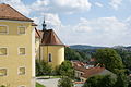
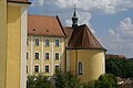
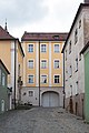
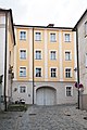
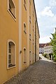
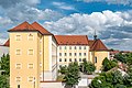
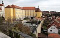
Deutsch: Sulzbach-Rosenberg - Klostergasse 2; Luitpoldplatz 13 - Ehem. Salesianerinnenkloster mit Klosterkirche St. Hedwig. Äußerer und innerer Flügel 1753-55, äußerer Flügel 1850 um ein Geschoß erhöht, Klosterkirche St. Hedwig 1762-65; anstelle des früheren Ballhauses des Schlosses errichtet.
building in Sulzbach-Rosenberg, Upper Palatinate, Germany | |||||
| Upload media | |||||
| Instance of | |||||
|---|---|---|---|---|---|
| Location | Sulzbach-Rosenberg, Amberg-Sulzbach, Upper Palatinate, Bavaria, Germany | ||||
| Has part(s) |
| ||||
 | |||||
Subcategories
This category has only the following subcategory.
H
- St. Hedwig (Sulzbach-Rosenberg) (11 F)
Media in category "Salesianerinnenkloster Sulzbach-Rosenberg"
The following 14 files are in this category, out of 14 total.
-
 2010.08.22.141353 Aussicht Burg Sulzbach-Rosenberg.jpg 1,920 × 1,280; 627 KB
-
 2010.08.22.141558 Aussicht Burg Sulzbach-Rosenberg.jpg 1,920 × 1,280; 824 KB
-
 2010.08.22.141834 Burg Sulzbach-Rosenberg.jpg 1,920 × 1,280; 608 KB
-
 Aerial image of Burg Sulzbach (view from the southeast).jpg 3,700 × 3,000; 4.08 MB
-
 Klostergasse 2 Sulzbach-Rosenberg 20180621 002.jpg 4,016 × 6,016; 9.45 MB
-
 Klostergasse 2 Sulzbach-Rosenberg 20180621 004.jpg 4,016 × 6,016; 9.72 MB
-
 Luitpoldplatz 13 Sulzbach-Rosenberg 20180621 001.jpg 6,016 × 4,016; 10.61 MB
-
 Luitpoldplatz 13 Sulzbach-Rosenberg 20180621 002.jpg 4,016 × 6,016; 12.44 MB
-
 Luitpoldplatz 13 Sulzbach-Rosenberg 20180621 003.jpg 4,016 × 6,016; 10.23 MB
-
 Luitpoldplatz 13 Sulzbach-Rosenberg 20180621 004.jpg 6,016 × 4,016; 11.78 MB
-
 Luitpoldplatz 13 Sulzbach-Rosenberg 20180621 005.jpg 4,996 × 3,335; 8.99 MB
-
 Luitpoldplatz 13 Sulzbach-Rosenberg 20180621 006.jpg 4,780 × 3,191; 8.44 MB
-
 Sulzbach 08.jpg 4,994 × 3,194; 7.31 MB
-
 Sulzbach-Rosenberg - Kloster - Rückseite 01.jpg 5,130 × 3,420; 6.7 MB


.jpg)


