Category:Sanda Island
Zur Navigation springen
Zur Suche springen
Insel im Vereinigten Königreich  | |||||
| Medium hochladen | |||||
| Ist ein(e) | |||||
|---|---|---|---|---|---|
| Ist Teil von | |||||
| Ort | Argyll and Bute, Schottland | ||||
| Liegt am oder im Gewässer | |||||
| Einwohnerzahl |
| ||||
| Fläche |
| ||||
 | |||||
Unterkategorien
Diese Kategorie enthält folgende Unterkategorie:
In Klammern die Anzahl der enthaltenen Kategorien (K), Seiten (S), Dateien (D)
S
- Sanda Island Lighthouse (10 D)
Medien in der Kategorie „Sanda Island“
Folgende 41 Dateien sind in dieser Kategorie, von 41 insgesamt.
-
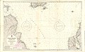
 Admiralty Chart No 1945 Scotland - west coast - Sanda Island, published 1849.jpg 7.989 × 5.426; 8,55 MB
-
 Admiralty Chart No 2159 Firth of Clyde, Published 1869.jpg 11.193 × 19.484; 22,08 MB
-
 Admiralty Chart No 2199 North Channel Northern Part, Published 1966.jpg 18.326 × 11.113; 12,45 MB
-
 Atlantic Grey Seals on Sanda Island - geograph.org.uk - 538245.jpg 640 × 480; 97 KB
-
 Blue sheep, Sanda - geograph.org.uk - 2934895.jpg 640 × 360; 216 KB
-
 Byrondarnton.jpg 640 × 480; 51 KB
-
 Cave at west end of Sanda Island - geograph.org.uk - 1807227.jpg 599 × 640; 43 KB
-
-
 Gully, west end of Sanda Island - geograph.org.uk - 1807230.jpg 427 × 640; 74 KB
-
 Lighthouse road, Sanda - geograph.org.uk - 2933455.jpg 640 × 360; 233 KB
-
 Loch, Sanda Island - geograph.org.uk - 1807240.jpg 640 × 426; 50 KB
-
 Mull of Kintyre, view towards Sanda - geograph.org.uk - 3286671.jpg 640 × 480; 50 KB
-

-
 Patterson's Rock - geograph.org.uk - 2933447.jpg 640 × 392; 244 KB
-
 Pier Cottage, Sanda Island - geograph.org.uk - 1807236.jpg 640 × 394; 60 KB
-
 Reiligshanndaigh.jpg 640 × 480; 60 KB
-
 Sanda - geograph.org.uk - 3042231.jpg 4.592 × 3.448; 2,44 MB
-
 Sanda and Sheep Island - geograph.org.uk - 2772494.jpg 640 × 480; 28 KB
-
 Sanda and Sheep Island - geograph.org.uk - 2933400.jpg 640 × 480; 281 KB
-
 Sanda from Dunaverty - geograph.org.uk - 2139252.jpg 1.024 × 768; 151 KB
-
 Sanda Island - geograph.org.uk - 735892.jpg 640 × 406; 183 KB
-
 Sanda Island from Macharioch Bay - geograph.org.uk - 3055877.jpg 1.600 × 1.200; 320 KB
-
 Sanda Island from Macharioch. - geograph.org.uk - 367183.jpg 640 × 480; 71 KB
-
 Sanda Island from the Antrim Coast - geograph.org.uk - 3730797.jpg 1.024 × 769; 61 KB
-
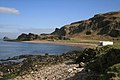
 Sanda Island Slipway - geograph.org.uk - 3252716.jpg 1.600 × 1.200; 485 KB
-
 Sanda, the triangulation pillar - geograph.org.uk - 2933416.jpg 640 × 480; 293 KB
-
 Sandaforeshore.jpg 640 × 480; 83 KB
-
 Sheep Island from Sanda Island - geograph.org.uk - 1807244.jpg 640 × 428; 34 KB
-
 Sheep Island Near Sanda Island - geograph.org.uk - 3252709.jpg 1.600 × 1.200; 427 KB
-
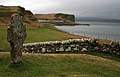
 St Ninian's Chapel, Sanda geograph-1807225-by-Becky-Williamson.jpg 640 × 261; 45 KB
-
 St Ninian's Chapel, Sanda Island - geograph.org.uk - 1807224.jpg 640 × 412; 96 KB
-
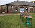
 The Boathouse, Sanda Island - geograph.org.uk - 1807238.jpg 640 × 426; 86 KB
-
 The Byron Darnton Tavern, Sanda Island - geograph.org.uk - 1807235.jpg 640 × 510; 123 KB
-
 Through Sound of Sanda towards Ailsa Craig - geograph.org.uk - 2139262.jpg 1.024 × 768; 136 KB
-
 Trig Point Sanda Island - geograph.org.uk - 3252024.jpg 1.600 × 1.200; 462 KB
-
 Trigpoint, Sanda Island - geograph.org.uk - 1807233.jpg 640 × 570; 55 KB
-
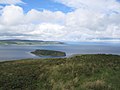 View from trig point on Sanda Island - geograph.org.uk - 1990706.jpg 1.600 × 1.200; 417 KB
-
 View towards Sanda Island - geograph.org.uk - 5724884.jpg 640 × 480; 96 KB
-
 Westernly point of Sanda Island - geograph.org.uk - 566036.jpg 640 × 480; 92 KB
-
 Wetland, Sanda - geograph.org.uk - 2933383.jpg 640 × 360; 227 KB
-
 The anchorage at Sanda - geograph.org.uk - 211093.jpg 640 × 480; 46 KB


