Category:Schapow church
Jump to navigation
Jump to search
| Object location | | View all coordinates using: OpenStreetMap |
|---|
 | |||||
| Upload media | |||||
| Instance of | |||||
|---|---|---|---|---|---|
| Location | Schapow, Nordwestuckermark, Uckermark District, Brandenburg, Germany | ||||
| Heritage designation | |||||
 | |||||
This is the category of the Brandenburger Baudenkmal (cultural heritage monument) with the ID 09130153 (Wikidata)
|
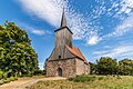
English: Pictures of the church in Schapow, Nordwestuckermark municipality, Uckermark district, Brandenburg state, Germany
Deutsch: Bilder der Kirche in Schapow, Gemeinde Nordwestuckermark, Landkreis Uckermark, Land Brandenburg, Deutschland.
Français : Photos de l'église à Schapow, commune de Nordwestuckermark, arrondissement de Uckermark, état fédéral de Brandebourg, Allemagne
Media in category "Schapow church"
The following 7 files are in this category, out of 7 total.
-
 Dorfkirche Schapow 2018 N.jpg 4,881 × 4,268; 7.6 MB
-
 Dorfkirche Schapow 2018 S.jpg 5,150 × 4,635; 10.02 MB
-
 Dorfkirche Schapow 2018 SW.jpg 4,864 × 3,648; 4.24 MB
-
 Dorfkirche Schapow 2018 vermauertes Nordportal.jpg 3,648 × 4,864; 6.53 MB
-
 Dorfkirche Schapow 2018 Westportal.jpg 3,648 × 4,864; 7.56 MB
-
 Dorfkirche Schapow 2018 WSW.jpg 3,522 × 4,772; 5.24 MB
-
 Schapow 07 18 07 jiw.jpg 1,920 × 1,280; 738 KB


