Category:Schinkelkirche (Neuhardenberg)
Jump to navigation
Jump to search
| Object location | | View all coordinates using: OpenStreetMap |
|---|
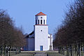
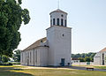
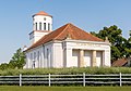
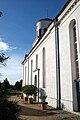
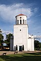
parish church in Neuhardenberg, Germany   | |||||
| Upload media | |||||
| Instance of | |||||
|---|---|---|---|---|---|
| Location | Neuhardenberg, Märkisch-Oderland District, Brandenburg, Germany | ||||
| Heritage designation | |||||
 | |||||
This is the category of the Brandenburger Baudenkmal (cultural heritage monument) with the ID 09180573 (Wikidata)
|
Deutsch: Bilder der Kirche in Neuhardenberg, Gemeinde Neuhardenberg, Landkreis Märkisch-Oderland, Land Brandenburg, Deutschland.
English: Pictures of the church in Neuhardenberg, Neuhardenberg municipality, Märkisch-Oderland district, Brandenburg state, Germany
Français : Photos de l'église à Neuhardenberg, commune de Neuhardenberg, arrondissement de Märkisch-Oderland, état fédéral de Brandebourg, Allemagne
Subcategories
This category has only the following subcategory.
I
Media in category "Schinkelkirche (Neuhardenberg)"
The following 18 files are in this category, out of 18 total.
-
 20040703330DR Neuhardenberg Schinkelkirche.jpg 2,515 × 1,779; 2.78 MB
-
 IMG 8798NeuhardenbergKirche.jpg 600 × 400; 81 KB
-
 IMG 8803NeuhardenbergKirche2.jpg 600 × 900; 138 KB
-
 Kirche Neuhardenberg (26417793061).jpg 4,912 × 3,264; 4.13 MB
-
 Neuhardenberg - 2015-07-04 - Schinkel-Kirche (03).jpg 3,500 × 2,515; 4.47 MB
-
 Neuhardenberg - 2015-07-04 - Schinkel-Kirche (07).jpg 3,500 × 2,286; 5.05 MB
-
 Neuhardenberg - 2015-07-04 - Schinkel-Kirche (09).jpg 3,500 × 2,456; 7.17 MB
-
 Neuhardenberg - 2015-07-04 - Schinkel-Kirche (13) cropped.jpg 1,620 × 1,185; 2.21 MB
-
 Neuhardenberg - 2015-07-04 - Schinkel-Kirche (13).jpg 3,500 × 2,432; 6.71 MB
-
 Neuhardenberg - 2015-07-04 - Schinkel-Kirche (14).jpg 3,500 × 2,607; 5.65 MB
-
 Neuhardenberg - Schinkel-Kirche - panoramio.jpg 640 × 480; 58 KB
-
 Neuhardenberg Schinkelkirche zwei.jpg 4,048 × 3,040; 1.75 MB
-
 Neuhardenberg Schinkelkirche.jpg 4,048 × 3,040; 1.17 MB
-
 Neuhardenberg mit Kirche.jpg 1,280 × 960; 132 KB
-
 Schinkel-Kirche.JPG 2,816 × 2,112; 1.41 MB
-
 Schinkelkirche.jpg 4,082 × 6,123; 6.05 MB
-
 Schloss Neuhardenberg 3.jpg 3,149 × 4,721; 3.09 MB
-
 Schlosspark Neuhardenberg.jpg 4,082 × 4,081; 7.16 MB


.jpg)
.jpg)
.jpg)
.jpg)
_cropped.jpg)
.jpg)
.jpg)


