Category:Schloss Steinfels
Jump to navigation
Jump to search
This is the category of the Bavarian Baudenkmal (cultural heritage monument) with the ID D-3-74-134-20 (Wikidata)
|
| Object location | | View all coordinates using: OpenStreetMap |
|---|
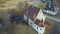
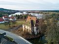
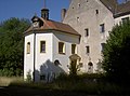
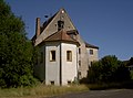
building in Mantel, Upper Palatinate, Germany  | |||||
| Upload media | |||||
| Instance of | |||||
|---|---|---|---|---|---|
| Location | Mantel, Neustadt an der Waldnaab, Upper Palatinate, Bavaria, Germany | ||||
| Street address |
| ||||
| Has part(s) |
| ||||
| Heritage designation | |||||
 | |||||
Media in category "Schloss Steinfels"
The following 16 files are in this category, out of 16 total.
-
 Schloss Steinfels (bei Mantel).jpg 3,956 × 2,638; 4.51 MB
-
 Schloss Steinfels 1.jpg 3,840 × 2,160; 3.2 MB
-
 Schloss Steinfels 2.jpg 3,840 × 2,160; 2.96 MB
-
 Schloss Steinfels 3.jpg 3,992 × 2,992; 4.15 MB
-
 Schloss Steinfels 4.jpg 3,992 × 2,680; 5.83 MB
-
 Schloss Steinfels.PNG 572 × 406; 542 KB
-
 SchlossSteinfels 05.jpg 2,304 × 1,704; 930 KB
-
 SchlossSteinfels 06.jpg 2,304 × 1,704; 793 KB
-
 SchlossSteinfels 07.jpg 2,304 × 1,704; 758 KB
-
 SchlossSteinfels 08.jpg 2,304 × 1,704; 780 KB
-
 SchlossSteinfels 09.jpg 2,304 × 1,704; 787 KB
-
 SchlossSteinfels 10.jpg 2,304 × 1,704; 875 KB
-
 SchlossSteinfels 11.jpg 2,304 × 1,704; 790 KB
-
 SchlossSteinfels 12.jpg 2,304 × 1,704; 734 KB
-
 SchlossSteinfels 13.jpg 2,304 × 1,704; 824 KB
-
 SchlossSteinfels 14.jpg 2,304 × 1,704; 849 KB
.jpg)


