Category:Schuilkerk De Hoop
Jump to navigation
Jump to search
| Object location | | View all coordinates using: OpenStreetMap |
|---|
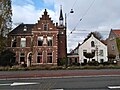
clandestine church and monument in Diemen, the Netherlands  | |||||
| Upload media | |||||
| Instance of | |||||
|---|---|---|---|---|---|
| Location | Diemen, North Holland, Netherlands | ||||
| Street address |
| ||||
| Located on street | |||||
| Heritage designation |
| ||||
| Religion or worldview | |||||
 | |||||
|
This is a category about rijksmonument number 452976
|
| Address |
|
Media in category "Schuilkerk De Hoop"
The following 5 files are in this category, out of 5 total.
-
 2021 Pastorie St-Petrus Bandenkerk en Schuilkerk de Hoop.jpg 2,576 × 1,932; 2 MB
-
 De Hoop kerk Diemen.jpg 3,264 × 2,448; 1.65 MB
-
 Schuilkerk de Hoop 2.JPG 1,512 × 2,048; 747 KB
-
 Schuilkerk De Hoop.jpg 740 × 500; 75 KB
-
 Schuilkerk de Hoop.JPG 3,044 × 2,244; 1.59 MB


