Category:Seaton Valley
Aller à la navigation
Aller à la recherche
civil parish in Northumberland, created in 2009 | |||||
| Téléverser des médias | |||||
| Nature de l’élément |
| ||||
|---|---|---|---|---|---|
| Lieu | Northumberland, Angleterre du Nord-Est, Angleterre | ||||
| Date de fondation ou de création |
| ||||
| Superficie |
| ||||
| À ne pas confondre avec | |||||
 | |||||
Sous-catégories
Cette catégorie comprend 6 sous-catégories, dont les 6 ci-dessous.
H
N
S
Média dans la catégorie « Seaton Valley »
Cette catégorie comprend 535 fichiers, dont les 200 ci-dessous.
(page précédente) (page suivante)-
 'Caesar ^ Pompey', Seaton Delaval Hall - geograph.org.uk - 5611080.jpg 1 024 × 768 ; 219 kio
-
 A muddy path, Lysdon - geograph.org.uk - 6036312.jpg 1 024 × 768 ; 330 kio
-
 A sunny day on the beach south of Blyth - geograph.org.uk - 3851562.jpg 640 × 480 ; 70 kio
-
 A Tranquil Stretch of the Seaton Burn - geograph.org.uk - 3499899.jpg 4 608 × 3 456 ; 3,29 Mio
-
 A1061 towards Cramlington - geograph.org.uk - 2974568.jpg 640 × 480 ; 42 kio
-
 A1061, Laverock Hall - geograph.org.uk - 6375116.jpg 1 024 × 576 ; 204 kio
-
 A190 towards Dudley - geograph.org.uk - 3060684.jpg 640 × 480 ; 83 kio
-
 A192 heading north - geograph.org.uk - 3058756.jpg 640 × 480 ; 54 kio
-
 A192 towards Earsdon - geograph.org.uk - 3058913.jpg 640 × 480 ; 76 kio
-
 A192 towards Earsdon - geograph.org.uk - 3058927.jpg 640 × 480 ; 60 kio
-
 A192 towards Earsdon - geograph.org.uk - 3058938.jpg 640 × 480 ; 48 kio
-
 A192, Seaton Delaval - geograph.org.uk - 6088614.jpg 1 024 × 768 ; 179 kio
-
 A193 Beresford Road, Hartley - geograph.org.uk - 5833456.jpg 1 024 × 710 ; 93 kio
-

-
 A193 Links Road, north of Seaton Sluice - geograph.org.uk - 5833461.jpg 1 024 × 739 ; 79 kio
-
 Access to Collywell Bay - geograph.org.uk - 4460303.jpg 640 × 360 ; 84 kio
-
 Across the fields - geograph.org.uk - 3035555.jpg 2 257 × 1 505 ; 1,58 Mio
-
 Agricultural land - geograph.org.uk - 153946.jpg 640 × 480 ; 120 kio
-
 Air shaft, Seaton Delaval Colliery - geograph.org.uk - 6038474.jpg 1 024 × 768 ; 374 kio
-
 Allotments and car park - geograph.org.uk - 3594416.jpg 640 × 428 ; 105 kio
-
 Arable field east of North Moor Farm - geograph.org.uk - 5879018.jpg 2 000 × 1 500 ; 518 kio
-
 Arable field gateway - geograph.org.uk - 5106067.jpg 2 000 × 1 500 ; 574 kio
-
 Arable field gateway - geograph.org.uk - 5106077.jpg 2 000 × 1 500 ; 558 kio
-
 Arable field next to New Hartley - geograph.org.uk - 5878969.jpg 2 000 × 1 500 ; 538 kio
-
 Arable field north east of Lysdon Farm - geograph.org.uk - 5879066.jpg 2 000 × 1 500 ; 489 kio
-
 Arable field north of West Field farm - geograph.org.uk - 5273354.jpg 2 000 × 1 500 ; 487 kio
-
 Arable field on the edge of New Hartley - geograph.org.uk - 5878963.jpg 2 000 × 1 500 ; 423 kio
-
 Arable field to the north of New Hartley - geograph.org.uk - 5879036.jpg 2 000 × 1 500 ; 439 kio
-
 Arable field west of Lysdon Farm - geograph.org.uk - 5879030.jpg 2 000 × 1 500 ; 577 kio
-
 Arable field, Middle Farm, Seghill - geograph.org.uk - 5653906.jpg 2 000 × 1 500 ; 504 kio
-
 Arable land at Lookout Farm - geograph.org.uk - 5105982.jpg 2 000 × 1 500 ; 423 kio
-
 Arable land at Lysdon Farm - geograph.org.uk - 5879088.jpg 2 000 × 1 500 ; 443 kio
-
 Arable land east of North Moor Farm - geograph.org.uk - 5879021.jpg 2 000 × 1 500 ; 555 kio
-
 Arable land near West Field farm - geograph.org.uk - 5273339.jpg 2 000 × 1 500 ; 271 kio
-
 Arable land off Links Road - geograph.org.uk - 5105958.jpg 2 000 × 1 500 ; 551 kio
-
 Arable land off the A192 - geograph.org.uk - 5991198.jpg 2 000 × 1 333 ; 300 kio
-
 Arable land south of Seghill - geograph.org.uk - 5652141.jpg 2 000 × 1 500 ; 392 kio
-
 Asteraceae Family - geograph.org.uk - 2928975.jpg 1 099 × 931 ; 834 kio
-
 Astley Arms, Seaton Sluice - geograph.org.uk - 5689409.jpg 5 335 × 3 001 ; 2,94 Mio
-
 Astley Community High School, Seaton Delaval - geograph.org.uk - 5655552.jpg 2 000 × 1 500 ; 266 kio
-
 Avenue Branch Line - geograph.org.uk - 902951.jpg 640 × 480 ; 92 kio
-
 Avenue Head Farm House - geograph.org.uk - 5262673.jpg 4 490 × 2 713 ; 6,35 Mio
-
 B1326 and car park, East Cramlington - geograph.org.uk - 6038574.jpg 1 024 × 768 ; 363 kio
-
 Backworth Lane (B1322) towards Seghill - geograph.org.uk - 3060671.jpg 640 × 480 ; 81 kio
-
 Bank protection, Holywell Dene - geograph.org.uk - 2822320.jpg 640 × 480 ; 140 kio
-
 Barley Close Up - geograph.org.uk - 3031298.jpg 640 × 480 ; 126 kio
-
 Barley Field - geograph.org.uk - 3030446.jpg 1 704 × 2 272 ; 1,77 Mio
-
 Beach between Seaton Sluice and Blyth - geograph.org.uk - 4845950.jpg 2 048 × 1 536 ; 817 kio
-
 Beach near Seaton Sluice - geograph.org.uk - 5610854.jpg 1 024 × 768 ; 227 kio
-
 Beach north of Seaton Sluice - geograph.org.uk - 6033869.jpg 640 × 480 ; 306 kio
-
 Beech Tree - geograph.org.uk - 5277418.jpg 4 193 × 3 145 ; 5,33 Mio
-
 Behind you^ - geograph.org.uk - 6033863.jpg 552 × 640 ; 321 kio
-
 Below Seaton Sluice Bridge - geograph.org.uk - 5616492.jpg 1 024 × 768 ; 214 kio
-
 Big spoon beside the footpath - geograph.org.uk - 5653919.jpg 2 000 × 1 500 ; 281 kio
-
 Bird table at Holywell Pond - geograph.org.uk - 2822288.jpg 640 × 480 ; 113 kio
-
 Blaketown, Seghill - geograph.org.uk - 5653872.jpg 2 000 × 1 500 ; 566 kio
-
 Blyth Beach (looking South) - geograph.org.uk - 4044595.jpg 640 × 480 ; 273 kio
-
 Blyth Beach (Looking Towards Blyth) - geograph.org.uk - 4044605.jpg 640 × 480 ; 216 kio
-
 Blyth Beach - geograph.org.uk - 4044591.jpg 640 × 480 ; 254 kio
-
 Blyth from Seaton Sluice - geograph.org.uk - 5616501.jpg 1 024 × 768 ; 201 kio
-
 Blyth from the air - geograph.org.uk - 2130668.jpg 2 592 × 1 944 ; 3,41 Mio
-
 Blyth from the air - geograph.org.uk - 5680075.jpg 640 × 480 ; 147 kio
-
 Blyth South Beach and Harbour - geograph.org.uk - 3851122.jpg 640 × 480 ; 50 kio
-
 Boat as planter - geograph.org.uk - 3338088.jpg 640 × 480 ; 81 kio
-
 Boat yard, Seaton Sluice - geograph.org.uk - 5626314.jpg 1 024 × 770 ; 237 kio
-
 Boats in the mud - geograph.org.uk - 5375124.jpg 640 × 480 ; 303 kio
-
 Bodgara Mill - geograph.org.uk - 1137676.jpg 640 × 480 ; 115 kio
-
 Bridge Crossing Seaton Burn - Holywell Dene - geograph.org.uk - 2752872.jpg 640 × 480 ; 116 kio
-
 Bridge ELM42 - geograph.org.uk - 902263.jpg 640 × 480 ; 137 kio
-
 Bridge over the former Avenue branch line - geograph.org.uk - 5106106.jpg 2 000 × 1 500 ; 911 kio
-
 Bridge under the Earsdon and Morpeth Line - geograph.org.uk - 6036322.jpg 1 024 × 768 ; 430 kio
-
 Bridleway east of Lysdon Farm - geograph.org.uk - 5879061.jpg 2 000 × 1 500 ; 810 kio
-
 Bridleway east of Lysdon Farm - geograph.org.uk - 5879075.jpg 2 000 × 1 500 ; 708 kio
-
 Bridleway towards Hartley - geograph.org.uk - 3058920.jpg 640 × 480 ; 57 kio
-
 Bridleway towards Monkseaton - geograph.org.uk - 5106009.jpg 2 000 × 1 500 ; 624 kio
-
 Bristol Street, New Hartley - geograph.org.uk - 5878105.jpg 2 000 × 1 500 ; 351 kio
-
 Bungalow on Fountain Head Bank - geograph.org.uk - 2974327.jpg 640 × 480 ; 59 kio
-
 Bunkers - geograph.org.uk - 99772.jpg 640 × 480 ; 94 kio
-
 Car Park - geograph.org.uk - 105437.jpg 640 × 480 ; 64 kio
-
 Car park at Old Hartley - geograph.org.uk - 4844231.jpg 2 048 × 1 536 ; 741 kio
-
 Car park on Links Road at Mile Hill - geograph.org.uk - 5893979.jpg 640 × 377 ; 49 kio
-
 Caravan Club Site, Old Hartley - geograph.org.uk - 3499761.jpg 4 608 × 3 456 ; 3,3 Mio
-
 Caravan park on the cliff at Hartley - geograph.org.uk - 2923632.jpg 1 500 × 1 000 ; 149 kio
-
 Castaways Tea Shop, Collywell Bay Road, Seaton Sluice - geograph.org.uk - 5617561.jpg 1 024 × 762 ; 222 kio
-
 Cattle Grid - geograph.org.uk - 102487.jpg 640 × 424 ; 83 kio
-
 Cemetery - geograph.org.uk - 3594448.jpg 640 × 428 ; 146 kio
-
 Charley's Garden, Collywell Bay - geograph.org.uk - 5245100.jpg 4 000 × 3 000 ; 4,8 Mio
-
 Charley's Garden, Collywell Bay - geograph.org.uk - 5624682.jpg 1 024 × 768 ; 282 kio
-
 Church of Our Lady from the Gardens - geograph.org.uk - 2468614.jpg 3 264 × 2 448 ; 2,39 Mio
-
 Churches, Station Road, Seaton Delaval - geograph.org.uk - 5658386.jpg 2 000 × 1 500 ; 264 kio
-
 Cliff reinforcement at Hartley - geograph.org.uk - 4352227.jpg 640 × 480 ; 256 kio
-
 Cliff top sea anglers at Crag Point - geograph.org.uk - 2822341.jpg 480 × 640 ; 80 kio
-
 Cliffs near Crag Point - geograph.org.uk - 5668498.jpg 5 376 × 3 024 ; 2,89 Mio
-
 Close up of Winter Frost - geograph.org.uk - 2766636.jpg 1 049 × 787 ; 633 kio
-
 Closed public toilets, Hartley Links - geograph.org.uk - 4845946.jpg 2 048 × 1 536 ; 926 kio
-
 Coast path, Old Hartley - geograph.org.uk - 3272778.jpg 640 × 360 ; 233 kio
-
 Coastal beacon at Seaton Sluice - geograph.org.uk - 6033865.jpg 640 × 480 ; 214 kio
-
 Coastal defences, Collywell Bay - geograph.org.uk - 5622351.jpg 769 × 1 024 ; 301 kio
-
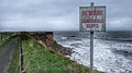
 Coastal Erosion (61391491).jpeg 2 048 × 1 356 ; 1,35 Mio
-
 Coastal Erosion, Hartley Bay - geograph.org.uk - 5245124.jpg 4 320 × 2 432 ; 4,31 Mio
-
 Coastal footpath at Hartley Bay - geograph.org.uk - 5899968.jpg 640 × 443 ; 88 kio
-
 Coastal rocks at Seaton Sluice - geograph.org.uk - 6033874.jpg 640 × 480 ; 311 kio
-
 Coastal rocks at Seaton Sluice - geograph.org.uk - 6033876.jpg 640 × 480 ; 278 kio
-
 Coastguard Lookout, Rocky Island, Seaton Sluice - geograph.org.uk - 5622279.jpg 1 024 × 750 ; 208 kio
-
 Coastline near Hartley - geograph.org.uk - 2974057.jpg 640 × 480 ; 89 kio
-
 Collywell Bay - geograph.org.uk - 3499770.jpg 4 608 × 3 456 ; 3,08 Mio
-
 Collywell Bay - geograph.org.uk - 4459741.jpg 640 × 480 ; 124 kio
-
 Collywell Bay - geograph.org.uk - 5245110.jpg 4 320 × 2 432 ; 4,27 Mio
-
 Collywell Bay - geograph.org.uk - 5617508.jpg 1 024 × 768 ; 230 kio
-
 Collywell Bay - geograph.org.uk - 5622387.jpg 1 024 × 768 ; 185 kio
-
 Collywell Bay at Seaton Sluice - geograph.org.uk - 5899976.jpg 640 × 395 ; 88 kio
-
 Collywell Bay Road, Seaton Sluice - geograph.org.uk - 5618244.jpg 1 024 × 768 ; 234 kio
-
 Community Garden, Seaton Delaval Hall - geograph.org.uk - 5618856.jpg 1 024 × 767 ; 380 kio
-
 Concrete anti-tank blocks, Hartley Links - geograph.org.uk - 5610865.jpg 1 024 × 770 ; 194 kio
-
 Coop supermarket, Blackhaugh Drive, Seaton Delaval - geograph.org.uk - 5655599.jpg 2 000 × 1 500 ; 258 kio
-
 Corner Stone, Masonic Hall, Seaton Delaval - geograph.org.uk - 5878069.jpg 2 000 × 1 500 ; 534 kio
-
 Cottages at Gloucester Lodge Farm - geograph.org.uk - 3730596.jpg 4 608 × 3 456 ; 4,62 Mio
-
 Crag Point - geograph.org.uk - 4460291.jpg 640 × 360 ; 77 kio
-
 Crag Point - geograph.org.uk - 5264728.jpg 1 600 × 1 048 ; 231 kio
-
 Crag Point - geograph.org.uk - 5668487.jpg 5 376 × 3 024 ; 2,73 Mio
-
 Crag Point, Hartley Bay - geograph.org.uk - 1208774.jpg 524 × 640 ; 142 kio
-
 Cultivated arable field - geograph.org.uk - 5878988.jpg 2 000 × 1 500 ; 562 kio
-
 Culvert on the beach - geograph.org.uk - 3852006.jpg 640 × 480 ; 131 kio
-
 Cut Field Boundary - geograph.org.uk - 3030434.jpg 1 704 × 2 272 ; 1,76 Mio
-
 Cycle - footpath through Holywell Dene - geograph.org.uk - 3460622.jpg 1 024 × 737 ; 295 kio
-
 Cycle -foot path Hartley Links - geograph.org.uk - 3272754.jpg 640 × 360 ; 232 kio
-
 Cycle Route Sign, Holywell Dene - geograph.org.uk - 2821554.jpg 1 446 × 1 783 ; 1,34 Mio
-

-
 Cycleway and path towards Blyth - geograph.org.uk - 5900423.jpg 640 × 456 ; 93 kio
-
 Cycling on the bridleway - geograph.org.uk - 5106092.jpg 2 000 × 1 500 ; 596 kio
-
 Cyclists on the beach - geograph.org.uk - 3851554.jpg 640 × 480 ; 84 kio
-
 Daffodils alongside the Seaton Burn, Holywell Dene - geograph.org.uk - 6417020.jpg 1 600 × 1 200 ; 1,04 Mio
-
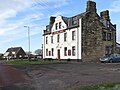 Delaval Arms, Old Hartley (geograph 5622883).jpg 1 024 × 769 ; 161 kio
-
 Delaval Trading Estate - geograph.org.uk - 5878100.jpg 2 000 × 1 500 ; 352 kio
-
 Delcor factory, Seaton Delaval - geograph.org.uk - 5878090.jpg 2 000 × 1 500 ; 317 kio
-
 Dereham Road, Hartley - geograph.org.uk - 3272770.jpg 640 × 360 ; 219 kio
-
 Dessert Spoon^ - geograph.org.uk - 2747337.jpg 480 × 640 ; 55 kio
-
 Dog walker on Seaton Sluice beach - geograph.org.uk - 6033879.jpg 640 × 360 ; 260 kio
-
 Double Decker Cafe - geograph.org.uk - 5374786.jpg 640 × 480 ; 197 kio
-
 Double decker cafe near Mile Hill, Hartley Links - geograph.org.uk - 5610872.jpg 1 024 × 768 ; 179 kio
-
 Double Row, Seaton Delaval - geograph.org.uk - 6038491.jpg 1 024 × 768 ; 266 kio
-
 Dunes at Hartley Links - geograph.org.uk - 4044574.jpg 640 × 480 ; 331 kio
-
 Dunes by the beach - geograph.org.uk - 2929142.jpg 1 500 × 1 000 ; 122 kio
-
 Dunes by the beach - geograph.org.uk - 2929162.jpg 1 500 × 1 000 ; 203 kio
-
 Dunes south of Blyth - geograph.org.uk - 2974362.jpg 640 × 480 ; 66 kio
-
 Earsdon Plants - geograph.org.uk - 2822293.jpg 640 × 480 ; 66 kio
-
 East Cramlington Nature Reserve - geograph.org.uk - 2773594.jpg 980 × 754 ; 170 kio
-
 East end of The Cut - geograph.org.uk - 3029006.jpg 1 600 × 1 200 ; 247 kio
-
 Eider in a choppy sea - geograph.org.uk - 5374798.jpg 640 × 480 ; 246 kio
-

-
 England Coast Path Signage, Near The Steadings, Hartley - geograph.org.uk - 6412785.jpg 1 200 × 1 600 ; 183 kio
-
 Entrance to Earsdon Plant Centre - geograph.org.uk - 5991196.jpg 2 000 × 1 333 ; 402 kio
-
 Eve Black Coastal Walkway - geograph.org.uk - 1736558.jpg 640 × 480 ; 70 kio
-
 Eve Black Coastal Walkway - geograph.org.uk - 2974339.jpg 640 × 480 ; 57 kio
-
 Eve Black Coastal Walkway - geograph.org.uk - 2974354.jpg 640 × 480 ; 55 kio
-
 Eve Black Coastal Walkway - geograph.org.uk - 3851081.jpg 640 × 480 ; 91 kio
-

-
 Eve Black Coastal Walkway, Blyth Beach - geograph.org.uk - 4044587.jpg 640 × 480 ; 278 kio
-
 Eve Black Coastal Walkway, Hartley Links - geograph.org.uk - 4044572.jpg 640 × 480 ; 280 kio
-
 Eve Black Coastal Walkway, Hartley Links - geograph.org.uk - 4635128.jpg 4 000 × 3 000 ; 4,82 Mio
-
 Fallen Tree - geograph.org.uk - 2928971.jpg 1 704 × 2 272 ; 1,99 Mio
-
 Farm buildings at Lysdon Farm - geograph.org.uk - 5879055.jpg 2 000 × 1 500 ; 470 kio
-
 Farm track and footpath, Seghill - geograph.org.uk - 5653903.jpg 2 000 × 1 500 ; 426 kio
-
 Farm track north of New Hartley - geograph.org.uk - 5878998.jpg 2 000 × 1 500 ; 564 kio
-
 Farm track off the A192 - geograph.org.uk - 3058934.jpg 640 × 480 ; 71 kio
-
 Farmhouse at Lysdon Farm - geograph.org.uk - 5879877.jpg 2 000 × 1 500 ; 489 kio
-
 Farmland near Earsdon - geograph.org.uk - 3058931.jpg 640 × 480 ; 65 kio
-
 Farmland off Backworth Lane - geograph.org.uk - 3060668.jpg 640 × 480 ; 93 kio
-
 Farmland off the A1061 - geograph.org.uk - 2974562.jpg 640 × 480 ; 55 kio
-
 Farmland off the A190 - geograph.org.uk - 3060682.jpg 640 × 480 ; 90 kio
-
 Farmland off the A192 - geograph.org.uk - 3058924.jpg 640 × 480 ; 74 kio
-
 Farmland west of Fenwick's Close Farm - geograph.org.uk - 5991186.jpg 2 000 × 1 333 ; 349 kio
-
 Farmland, Seaton Red House Farm - geograph.org.uk - 3058809.jpg 640 × 480 ; 62 kio
-
 Field Drains - geograph.org.uk - 3031323.jpg 1 704 × 2 272 ; 1,71 Mio
-
 Field Gateway off The Avenue - geograph.org.uk - 5106001.jpg 2 000 × 1 500 ; 560 kio
-
 Field margin, Lysdon - geograph.org.uk - 6036325.jpg 1 024 × 768 ; 310 kio
-
 Fields Adjoining Holywell Dene - geograph.org.uk - 2766687.jpg 2 272 × 1 058 ; 1,33 Mio
-
 Fields of Barley - geograph.org.uk - 3030412.jpg 1 704 × 2 272 ; 1,91 Mio
-
 Fields of Barley - geograph.org.uk - 3035561.jpg 1 258 × 1 704 ; 1,31 Mio
-
 Fields of Gold - geograph.org.uk - 3030403.jpg 2 272 × 1 704 ; 1,97 Mio
-
 Figures in the landscape - geograph.org.uk - 5375136.jpg 640 × 480 ; 385 kio
-
 Filling station, Blackhaugh Drive, Seaton Delaval - geograph.org.uk - 5655595.jpg 2 000 × 1 500 ; 258 kio
-
 Fireplace, Seaton Delaval Hall - geograph.org.uk - 5611917.jpg 1 024 × 782 ; 219 kio
-
 Flat arable land - geograph.org.uk - 5991189.jpg 2 000 × 1 333 ; 333 kio
-
 Flytipped rubbish in a field gateway - geograph.org.uk - 5991192.jpg 2 000 × 1 333 ; 696 kio
-
 Footbridge in Holywell Dene - geograph.org.uk - 2817873.jpg 640 × 480 ; 169 kio
-
 Footbridge in Holywell Dene - geograph.org.uk - 2822309.jpg 640 × 480 ; 166 kio
-
 Footbridge over a disused wagon way, now a footpath, Holywell Dene - geograph.org.uk - 3499996.jpg 4 608 × 3 456 ; 3,21 Mio
-
 Footbridge over old disused wagon way, Holywell Dene - geograph.org.uk - 3499988.jpg 4 608 × 3 456 ; 3,15 Mio
-
 Footbridge over the Seaton Burn - geograph.org.uk - 5260232.jpg 4 320 × 2 880 ; 6,28 Mio
-
 Footpath along the coast - geograph.org.uk - 4844223.jpg 2 048 × 1 536 ; 993 kio
-
 Footpath around field towards Holywell Dene - geograph.org.uk - 3035460.jpg 1 704 × 2 272 ; 1,69 Mio
-
 Footpath at the entrance to Holywell Dene - geograph.org.uk - 3499853.jpg 4 608 × 3 456 ; 3,28 Mio
-
 Footpath down Holywell Dene - geograph.org.uk - 2822312.jpg 640 × 480 ; 153 kio
-
 Footpath heading north from Lysdon Farm - geograph.org.uk - 5879879.jpg 2 000 × 1 500 ; 595 kio
-
 Footpath leading from Holywell Dene towards Seaton Delaval Hall - geograph.org.uk - 3500002.jpg 4 608 × 3 456 ; 2,98 Mio
-
 Footpath north of Earsdon - geograph.org.uk - 5991185.jpg 2 000 × 1 333 ; 420 kio
-

-
 Footpath to Earsdon Village - geograph.org.uk - 2184417.jpg 1 600 × 1 200 ; 468 kio
-
 Footpath towards Backworth - geograph.org.uk - 3035538.jpg 1 704 × 2 272 ; 1,75 Mio


_towards_Seghill_-_geograph.org.uk_-_3060671.jpg)


_-_geograph.org.uk_-_4044595.jpg)
_-_geograph.org.uk_-_4044605.jpg)


.jpeg)


.jpg)


