Category:Shelley, West Yorkshire
Jump to navigation
Jump to search
village in West Yorkshire, United Kingdom  | |||||
| Upload media | |||||
| Instance of | |||||
|---|---|---|---|---|---|
| Location | Kirkburton, Kirklees, West Yorkshire, Yorkshire and the Humber, England | ||||
| Different from | |||||
 | |||||
English: Shelley is a village in the county of West Yorkshire, England, 3 miles (5 km) north of Holmfirth and 6 miles (9.5 km) south east of Huddersfield. It sometimes appears as Shelley Woodhouse and has a population of 3,059 (2001 census). [1] It is part of the Kirkburton ward of the local council. Road transport links are provided by the A629 and B6116. With the closure of Clayton West railway station and subsequent reopening of much of the branch line as Kirklees Light Railway, Shelley finally acquired a rail station in 1997.
Subcategories
This category has the following 4 subcategories, out of 4 total.
Media in category "Shelley, West Yorkshire"
The following 27 files are in this category, out of 27 total.
-
 18 and 20, Dam Hill, Shelley.jpg 4,000 × 3,000; 2.07 MB
-
 Beck upstream of Shelley Bank Bottom - geograph.org.uk - 786607.jpg 541 × 640; 126 KB
-

-
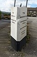
 Boundary stone, Shelley Bank Bottom - geograph.org.uk - 786614.jpg 640 × 474; 106 KB
-
 Dam Hill, Shelley, Yorkshire - geograph.org.uk - 119436.jpg 640 × 480; 113 KB
-
 Doctor Lane, Shelley - geograph.org.uk - 786633.jpg 640 × 475; 89 KB
-

-
 Guide Post, Shelley.jpg 524 × 800; 112 KB
-
 Guidestone and Far Bank, Shelley - geograph.org.uk - 786658.jpg 640 × 594; 78 KB
-
 Hawthorne Way, Shelley - geograph.org.uk - 126391.jpg 640 × 480; 72 KB
-
 Houses off Doctor Lane, Shelley - geograph.org.uk - 786638.jpg 640 × 480; 83 KB
-
-
 Houses, Near Bank, Shelley - geograph.org.uk - 786757.jpg 640 × 480; 97 KB
-

-
 Is this a 'real' postbox - geograph.org.uk - 570598.jpg 640 × 480; 123 KB
-
 Kirklea, off Bark House Lane, Shelley - geograph.org.uk - 786773.jpg 640 × 480; 97 KB
-
 Long Lane, Shelley, Yorkshire - geograph.org.uk - 119627.jpg 640 × 480; 150 KB
-
 Long Moor Lane, Shelley - geograph.org.uk - 2794344.jpg 640 × 426; 95 KB
-
 Multi Storey garden centre trolleys - geograph.org.uk - 863691.jpg 640 × 504; 101 KB
-
 Pond, Shelley Woodhouse - geograph.org.uk - 117441.jpg 640 × 480; 123 KB
-

-
 Railway Bridge across Long Moor Lane - geograph.org.uk - 117469.jpg 640 × 480; 88 KB
-
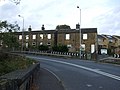
 Shelley Far Bank - geograph.org.uk - 786620.jpg 640 × 460; 71 KB
-

-
 Thunderbridge Lane, Shelley - geograph.org.uk - 396764.jpg 640 × 480; 160 KB
-
 Water Lane, Shelley - geograph.org.uk - 786643.jpg 640 × 478; 105 KB
-
 Wood Nook, Huddersfield Road, Shelley - geograph.org.uk - 796165.jpg 640 × 421; 73 KB


,_Shelley_-_geograph.org.uk_-_4193897.jpg)


