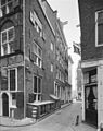
Category:Sint Olofspoort 4, Amsterdam
Jump to navigation
Jump to search
| Object location | | View all coordinates using: OpenStreetMap |
|---|
house in Amsterdam, Netherlands  | |||||
| Upload media | |||||
| Instance of | |||||
|---|---|---|---|---|---|
| Location | Amsterdam, North Holland, Netherlands | ||||
| Street address |
| ||||
| Located on street | |||||
| Owned by |
| ||||
| Heritage designation |
| ||||
| Inception |
| ||||
 | |||||
|
This is a category about rijksmonument number 5488
|
| Address |
|
Media in category "Sint Olofspoort 4, Amsterdam"
The following 2 files are in this category, out of 2 total.
-
 Exterieur VOORGEVELS OVERZICHT - Amsterdam - 20298719 - RCE.jpg 951 × 1,200; 303 KB
-
 St.Olofspoort 4.JPG 2,448 × 3,264; 1.67 MB
