Category:Sint-Andreaskerk, Weurt
Jump to navigation
Jump to search
| Object location | | View all coordinates using: OpenStreetMap |
|---|
church in Weurt, Netherlands _church,_the_tower.JPG) | |||||
| Upload media | |||||
| Instance of | |||||
|---|---|---|---|---|---|
| Named after | |||||
| Dedicated to | |||||
| Location | Weurt, Gelderland, Netherlands | ||||
| Street address |
| ||||
| Architect | |||||
| Heritage designation |
| ||||
| Inception |
| ||||
| Religion or worldview | |||||
 | |||||
|
This is a category about rijksmonument number 523158
|
| Address |
|
Media in category "Sint-Andreaskerk, Weurt"
The following 32 files are in this category, out of 32 total.
-
 Beschildering schip noord-oost zijde - Weurt - 20255446 - RCE.jpg 1,200 × 950; 313 KB
-
 Beschildering tongewelf - Weurt - 20255443 - RCE.jpg 961 × 1,200; 361 KB
-
 Ciborie - Weurt - 20255454 - RCE.jpg 962 × 1,200; 104 KB
-
 Detail beschildering schip - Weurt - 20255447 - RCE.jpg 1,200 × 953; 292 KB
-
 Detail ciborie - Weurt - 20255455 - RCE.jpg 962 × 1,200; 142 KB
-
 Doopbekken - Weurt - 20255453 - RCE.jpg 945 × 1,200; 140 KB
-
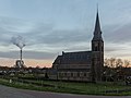
 Exterieur met omgeving - Weurt - 20255460 - RCE.jpg 1,200 × 878; 199 KB
-
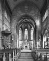
 Interieur naar het oosten - Weurt - 20255440 - RCE.jpg 955 × 1,200; 305 KB
-
 Interieur naar het oosten - Weurt - 20255441 - RCE.jpg 958 × 1,200; 306 KB
-
 Interieur naar het westen - Weurt - 20255462 - RCE.jpg 953 × 1,200; 311 KB
-
 Interieur, aanzicht orgel, orgelnummer 1656 - Weurt - 20368983 - RCE.jpg 838 × 1,200; 169 KB
-
 Kelk - Weurt - 20255451 - RCE.jpg 950 × 1,200; 100 KB
-
 Kelk, 1858 - Weurt - 20255452 - RCE.jpg 956 × 1,200; 111 KB
-
 Lavaboketel - Weurt - 20255449 - RCE.jpg 954 × 1,200; 163 KB
-
 Noord-oost gevel - Beuningen - 20034278 - RCE.jpg 1,200 × 946; 197 KB
-
 Noord-west aanzicht - Weert - 20251671 - RCE.jpg 873 × 1,200; 219 KB
-
 Noord-west aanzicht, Verzameling Mulder - Weurt - 20255463 - RCE.jpg 870 × 1,200; 200 KB
-
 Overzicht - Weurt - 20255461 - RCE.jpg 1,200 × 950; 262 KB
-
 Overzicht beschildering schip aan de noordzijde - Weurt - 20255445 - RCE.jpg 1,200 × 939; 312 KB
-
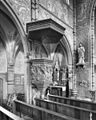 Preekstoel - Weurt - 20255448 - RCE.jpg 959 × 1,200; 317 KB
-
 Schildering zijbeuk - Weurt - 20255444 - RCE.jpg 970 × 1,200; 256 KB
-
 Toren montrans - Weurt - 20255456 - RCE.jpg 951 × 1,200; 113 KB
-
 Toren montrans - Weurt - 20255457 - RCE.jpg 941 × 1,200; 116 KB
-
 Toren montrans - Weurt - 20255458 - RCE.jpg 955 × 1,200; 138 KB
-
 Toren montrans - Weurt - 20255459 - RCE.jpg 959 × 1,200; 231 KB
-
 Vergezicht van de kerk in zijn omgeveing - Weurt - 20359743 - RCE.jpg 1,200 × 788; 167 KB
-
 Weurt (Beuningen, Gld, NL) church, the tower.JPG 3,000 × 4,000; 3.87 MB
-
 Weurt (Beuningen, Gld, NL) Waalbandijk 2.JPG 4,000 × 3,000; 4.13 MB
-
 Weurt (Beuningen, Gld, NL) Waalbandijk 3.JPG 4,000 × 3,000; 4.31 MB
-
 Weurt de Sint-Andreaskerk RM523158 foto3 2014-11-24 16.28.jpg 4,352 × 3,264; 7.79 MB
-
 Wierook outfit - Weurt - 20255450 - RCE.jpg 951 × 1,200; 127 KB
-
 Zijbeuk zuidzijde - Weurt - 20255442 - RCE.jpg 955 × 1,200; 269 KB


_Waalbandijk_2.JPG)
_Waalbandijk_3.JPG)


