Category:Sint-Andrieskerk (Antwerp)
Jump to navigation
Jump to search
| Object location | | View all coordinates using: OpenStreetMap |
|---|
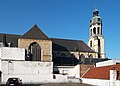
church building in Antwerp, Belgium  | |||||
| Upload media | |||||
| Instance of | |||||
|---|---|---|---|---|---|
| Named after | |||||
| Dedicated to | |||||
| Location | Antwerp, Arrondissement of Antwerp, Province of Antwerp, Flemish Region, Belgium | ||||
| Architectural style | |||||
| Diocese | |||||
| Heritage designation | |||||
| official website | |||||
 | |||||
|
This is a category about Beschermd erfgoed number 6154
|
|
This is a category about onroerend erfgoed number 6299
|
Subcategories
This category has the following 2 subcategories, out of 2 total.
I
Media in category "Sint-Andrieskerk (Antwerp)"
The following 19 files are in this category, out of 19 total.
-
 Antwerp Andrieskerk.jpg 3,569 × 2,545; 1.16 MB
-
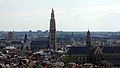 Antwerpen vanop mas 2.JPG 3,592 × 2,032; 4.69 MB
-
 Antwerpen Waaistraat 1 - 22936 - onroerenderfgoed.jpg 1,500 × 1,000; 184 KB
-
 Antwerpen Waaistraat 1 - 24817 - onroerenderfgoed.jpg 1,500 × 1,000; 202 KB
-
 Antwerpen Waaistraat 1 - 35688 - onroerenderfgoed.jpg 591 × 872; 90 KB
-
 De pomp op de veemarkt.jpg 1,908 × 2,709; 737 KB
-
 De preekstoel van de Sint-Andrieskerk te Antwerpen.jpg 4,407 × 3,457; 1.69 MB
-
 De preekstoel van de Sint-Andrieskerk, Antwerpen.jpg 3,039 × 4,154; 2.08 MB
-
 De Sint-Andrieskerk te Antwerpen, binnenzicht.jpg 4,751 × 6,383; 4.79 MB
-
 De Sint-Andrieskerk, Antwerpen, van binnen (Nash).jpg 3,828 × 5,151; 4.03 MB
-

-
 Mausoleum voor Mary Stuart in de Sint-Andrieskerk, Antwerpen (2).jpg 2,037 × 2,745; 933 KB
-
 Mausoleum voor Mary Stuart in de Sint-Andrieskerk, Antwerpen.jpg 4,425 × 3,441; 1.74 MB
-
 Sint-Andries Netje.JPG 1,224 × 1,632; 837 KB
-
 Sint-Andrieskerk Antwerpen 01.jpg 5,472 × 3,648; 4.8 MB
-
 Sint-Andrieskerk Antwerpen 02.jpg 3,648 × 5,472; 6.44 MB
-
 St Andrew's church - 1565.jpg 348 × 567; 139 KB
-
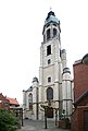
 St Andries Church Tower in Antwerp - panoramio.jpg 2,478 × 4,230; 2.86 MB
-


.jpg)
.jpg)


