Category:Sint-Jan de Doperkerk (Wateringen)
Jump to navigation
Jump to search
| Object location | | View all coordinates using: OpenStreetMap |
|---|
church building in Westland, Netherlands  | |||||
| Upload media | |||||
| Instance of | |||||
|---|---|---|---|---|---|
| Part of | |||||
| Location | Wateringen, Westland, South Holland, Netherlands | ||||
| Street address |
| ||||
| Located on street |
| ||||
| Architect | |||||
| Heritage designation |
| ||||
| Inception |
| ||||
| Religion or worldview | |||||
 | |||||
|
This is a category about rijksmonument number 38406
|
| Address |
|
Subcategories
This category has the following 2 subcategories, out of 2 total.
H
- Heilig Hartbeeld, Wateringen (2 F)
Media in category "Sint-Jan de Doperkerk (Wateringen)"
The following 53 files are in this category, out of 53 total.
-
 Exterieur - Wateringen - 20251254 - RCE.jpg 960 × 1,200; 167 KB
-
 Exterieur - Wateringen - 20251255 - RCE.jpg 951 × 1,200; 239 KB
-
 Gebrandschilderd raam - Wateringen - 20251258 - RCE.jpg 1,200 × 1,200; 378 KB
-
 Gebrandschilderd raam - Wateringen - 20251259 - RCE.jpg 1,192 × 1,200; 411 KB
-
 Gebrandschilderd raam - Wateringen - 20251260 - RCE.jpg 1,200 × 1,195; 344 KB
-
 Gebrandschilderd raam - Wateringen - 20251261 - RCE.jpg 960 × 1,200; 222 KB
-
 Gebrandschilderd raam - Wateringen - 20251262 - RCE.jpg 959 × 1,200; 216 KB
-
 Gebrandschilderd raam - Wateringen - 20251263 - RCE.jpg 956 × 1,200; 241 KB
-
 Gebrandschilderd raam - Wateringen - 20251264 - RCE.jpg 961 × 1,200; 245 KB
-
 Gebrandschilderd raam - Wateringen - 20251265 - RCE.jpg 958 × 1,200; 222 KB
-
 Gebrandschilderd raam - Wateringen - 20251266 - RCE.jpg 960 × 1,200; 251 KB
-
 Gebrandschilderd raam - Wateringen - 20251267 - RCE.jpg 964 × 1,200; 239 KB
-
 Gebrandschilderd raam - Wateringen - 20251268 - RCE.jpg 961 × 1,200; 207 KB
-
 Gebrandschilderd raam - Wateringen - 20251269 - RCE.jpg 960 × 1,200; 223 KB
-
 Gebrandschilderd raam - Wateringen - 20251270 - RCE.jpg 960 × 1,200; 212 KB
-
 Gebrandschilderd raam - Wateringen - 20251271 - RCE.jpg 958 × 1,200; 211 KB
-
 Gebrandschilderd raam - Wateringen - 20251272 - RCE.jpg 960 × 1,200; 194 KB
-
 Gebrandschilderd raam - Wateringen - 20251273 - RCE.jpg 960 × 1,200; 221 KB
-
 Gebrandschilderd raam - Wateringen - 20251274 - RCE.jpg 959 × 1,200; 221 KB
-
 Gebrandschilderd raam - Wateringen - 20251275 - RCE.jpg 960 × 1,200; 233 KB
-
 Gebrandschilderd raam - Wateringen - 20251276 - RCE.jpg 960 × 1,200; 213 KB
-
 Gebrandschilderd raam - Wateringen - 20251277 - RCE.jpg 957 × 1,200; 243 KB
-
 Gebrandschilderd raam - Wateringen - 20251278 - RCE.jpg 954 × 1,200; 267 KB
-
 Gebrandschilderd raam - Wateringen - 20251279 - RCE.jpg 975 × 1,200; 246 KB
-
 Gebrandschilderd raam - Wateringen - 20251280 - RCE.jpg 960 × 1,200; 217 KB
-
 Gebrandschilderd raam - Wateringen - 20251281 - RCE.jpg 963 × 1,200; 224 KB
-
 Gebrandschilderd raam - Wateringen - 20251282 - RCE.jpg 960 × 1,200; 245 KB
-
 Gebrandschilderd raam - Wateringen - 20251283 - RCE.jpg 964 × 1,200; 284 KB
-
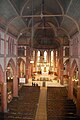
 Interieur - Wateringen - 20251256 - RCE.jpg 1,200 × 957; 273 KB
-
 Interieur naar het koor - Wateringen - 20251257 - RCE.jpg 1,200 × 960; 293 KB
-

-
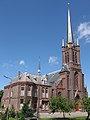
 Jan de Doperkerk - Wateringen-01.JPG 2,592 × 3,872; 2.45 MB
-
 Jan de Doperkerk - Wateringen-02.JPG 2,592 × 3,872; 2.46 MB
-
 Jan de Doperkerk - Wateringen-03.JPG 3,872 × 2,592; 2.51 MB
-
 Jan de Doperkerk - Wateringen-04.JPG 3,872 × 2,592; 2.47 MB
-
 Jan de Doperkerk - Wateringen-05.JPG 2,592 × 3,872; 2.51 MB
-
 Jan de Doperkerk - Wateringen-06.JPG 3,872 × 2,592; 2.51 MB
-
 Jan de Doperkerk - Wateringen-07.JPG 3,872 × 2,592; 2.74 MB
-
 Jan de Doperkerk - Wateringen-08.JPG 2,592 × 3,872; 2.52 MB
-
 Jan de Doperkerk-Wateringen-09.JPG 2,592 × 3,872; 2.45 MB
-
 Jan de Doperkerk-Wateringen-10.JPG 3,872 × 2,592; 2.49 MB
-
 Jan de Doperkerk-Wateringen-11.JPG 2,592 × 3,872; 2.48 MB
-
 Jan de Doperkerk-Wateringen-12.JPG 2,592 × 3,872; 2.47 MB
-
 Jan de Doperkerk-Wateringen-13.JPG 3,872 × 2,592; 2.46 MB
-
 Jan de Doperkerk-Wateringen-14.JPG 2,592 × 3,872; 2.54 MB
-
 Jan de Doperkerk-Wateringen-15.JPG 2,592 × 3,872; 2.42 MB
-
 Jan de Doperkerk-Wateringen-16.JPG 2,592 × 3,872; 2.22 MB
-
 Wateringen - St-Jan de Doper - Fruitmuur.JPG 3,872 × 2,592; 2.06 MB
-
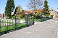 Wateringen - St-Jan de Doper - Hekwerk.JPG 3,872 × 2,592; 2.36 MB
-
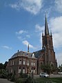
 Wateringen - St. Jan de Doper (zij).jpg 1,419 × 1,891; 1.12 MB
-
 Wateringen - St. Jan de Doper.jpg 1,367 × 1,822; 846 KB
-
 Wateringen, Sint Jan de Doperkerk foto2 2009-09-27 12.55-cor-1.jpg 2,020 × 3,132; 3.94 MB
-
 Wateringen, Sint Jan de Doperkerk foto2 2009-09-27 12.55.JPG 2,592 × 3,456; 2.21 MB


.jpg)

