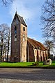
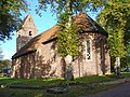
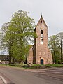
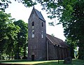
Category:Sint-Margaretakerk (Norg)
Jump to navigation
Jump to search
| Object location | | View all coordinates using: OpenStreetMap |
|---|
church building in Norg, Netherlands  | |||||
| Upload media | |||||
| Instance of | |||||
|---|---|---|---|---|---|
| Dedicated to | |||||
| Location | Norg, Drenthe, Netherlands | ||||
| Located on street |
| ||||
| Has part(s) | |||||
| Inception |
| ||||
| official website | |||||
 | |||||
Nederlands: Sint-Margaretakerk - anno 13e eeuw
Toren:
|
This is a category about rijksmonument number 30782
|
Kerk:
|
This is a category about rijksmonument number 30783
|
| Address |
|
Subcategories
This category has only the following subcategory.
Media in category "Sint-Margaretakerk (Norg)"
The following 67 files are in this category, out of 67 total.
-
 20171016 Sint-Margaretakerk Norg1.jpg 2,592 × 1,728; 1.49 MB
-
 20171016 Sint-Margaretakerk Norg2.jpg 1,548 × 2,322; 1.02 MB
-
 20201125 Sint-Margaretakerk1 Norg.jpg 3,456 × 5,184; 4.32 MB
-
 20201125 Sint-Margaretakerk2 Norg.jpg 3,456 × 5,184; 4.6 MB
-
 Exterieur noord-zijde - Norg - 20170017 - RCE.jpg 1,200 × 960; 410 KB
-
 Exterieur noord-zijde, detail - Norg - 20170018 - RCE.jpg 960 × 1,200; 375 KB
-
 Exterieur overzicht zuidwestgevel - Norg - 20321855 - RCE.jpg 1,200 × 978; 363 KB
-
 Exterieur zuid zijde - Norg - 20170020 - RCE.jpg 958 × 1,200; 318 KB
-
 Exterieur zuid-oost zijde - Norg - 20169977 - RCE.jpg 804 × 1,200; 349 KB
-
 Exterieur zuid-oost zijde - Norg - 20170019 - RCE.jpg 1,200 × 967; 393 KB
-
 Exterieur zuid-west zijde - Norg - 20169975 - RCE.jpg 802 × 1,200; 247 KB
-
 Exterieur zuid-west zijde - Norg - 20169976 - RCE.jpg 1,200 × 801; 361 KB
-
 Exterieur zuid-west zijde - Norg - 20170016 - RCE.jpg 1,200 × 965; 342 KB
-
 Galmgat - Norg - 20170003 - RCE.jpg 747 × 1,200; 192 KB
-
 Galmgat in oost gevel toren, koordak naar het oosten - Norg - 20169996 - RCE.jpg 1,200 × 788; 318 KB
-
 Galmgat in oost gevel toren, koordak naar het oosten - Norg - 20169997 - RCE.jpg 788 × 1,200; 236 KB
-
 Interieur koorgewelf - Norg - 20170023 - RCE.jpg 1,200 × 954; 185 KB
-
 Interieur koorgewelf - Norg - 20170024 - RCE.jpg 970 × 1,200; 214 KB
-
 Interieur koorgewelf, detail - Norg - 20170025 - RCE.jpg 1,200 × 976; 253 KB
-
 Interieur naar het oosten - Norg - 20169939 - RCE.jpg 1,200 × 957; 168 KB
-
 Interieur naar het oosten - Norg - 20169940 - RCE.jpg 1,200 × 955; 144 KB
-
 Interieur naar het oosten - Norg - 20169983 - RCE.jpg 1,200 × 804; 162 KB
-
 Interieur naar het oosten - Norg - 20170021 - RCE.jpg 1,200 × 954; 167 KB
-
 Interieur naar het westen - Norg - 20169938 - RCE.jpg 1,200 × 957; 183 KB
-
 Interieur naar het westen - Norg - 20170022 - RCE.jpg 961 × 1,200; 180 KB
-
 Interieur zuid-zijde, deurdetail - Norg - 20170027 - RCE.jpg 964 × 1,200; 169 KB
-
 Interieur, aanzicht orgel, orgelnummer 1103 - Norg - 20417266 - RCE.jpg 837 × 1,200; 160 KB
-
 Inwendig naar het oosten - Norg - 20169935 - RCE.jpg 1,200 × 890; 130 KB
-
 Kerk en omgeving vanuit het westen - Norg - 20169936 - RCE.jpg 1,200 × 797; 235 KB
-
 Kerk vanuit het noord-oosten - Norg - 20169934 - RCE.jpg 1,200 × 889; 228 KB
-
 Klokstrop - Norg - 20170011 - RCE.jpg 788 × 1,200; 198 KB
-

-
 Koor zuid zijde, detail gewelfaanzet - Norg - 20170026 - RCE.jpg 962 × 1,200; 224 KB
-
 Margarethakerk Norg binnen.jpg 4,624 × 3,468; 4.45 MB
-
 Margarethakerk Norg ingang.jpg 3,468 × 4,624; 6.84 MB
-
 Margarethakerk Norg2.jpg 1,296 × 972; 328 KB
-
 Margarethakkerk, Norg.jpg 3,000 × 4,000; 4.92 MB
-
 Nis in west muur schip - Norg - 20169970 - RCE.jpg 804 × 1,200; 182 KB
-
 Noarch, Margaretatsjerke, ferwulft koer.jpg 5,477 × 3,651; 20.23 MB
-
 Noarch, Margaretatsjerke, hearebank.jpg 5,352 × 3,702; 8.08 MB
-
 Noarch, Margaretatsjerke, kânsel.jpg 3,445 × 5,167; 8.28 MB
-
 Noarch, Margaretatsjerke, Leichel-oargel.jpg 3,406 × 5,128; 6.57 MB
-
 Noarch, Margaretatsjerke, romaansk doopfont.jpg 3,859 × 3,861; 10.14 MB
-
 Noarch, Margaretatsjerke, ynterieur rjochting koer.jpg 6,000 × 4,000; 10.76 MB
-
 Noarch, Margaretatsjerke.jpg 5,372 × 3,722; 16.14 MB
-
 Noord-gevel naar het westen - Norg - 20169978 - RCE.jpg 804 × 1,200; 321 KB
-
 Noord-gevel, 2e raam vanuit het oosten - Norg - 20169979 - RCE.jpg 804 × 1,200; 262 KB
-
 Noord-gevel, raam - Norg - 20169949 - RCE.jpg 954 × 1,200; 374 KB
-
 Noord-oost zijde - Norg - 20169947 - RCE.jpg 951 × 1,200; 360 KB
-
 Noord-zijde raam detail - Norg - 20169948 - RCE.jpg 960 × 1,200; 392 KB
-
 Noord-zijde, detail profilering metselwerk - Norg - 20169988 - RCE.jpg 1,200 × 786; 189 KB
-
 Norg Kerk 13 05 31 400000.jpeg 4,032 × 3,024; 4.77 MB
-
 Norg Kerk.jpeg 4,032 × 3,024; 4.97 MB
-
 Norg, de Sint Margaretakerk RM30783 foto3 2015-05-10 17.45.jpg 3,264 × 4,352; 12.06 MB
-
 NorgChurch.jpg 2,134 × 2,848; 1.03 MB
-
 Oost-zijde - Norg - 20169946 - RCE.jpg 958 × 1,200; 387 KB
-
 Overzicht van toren, naar het noorden - Norg - 20169990 - RCE.jpg 788 × 1,200; 275 KB
-
 Overzicht van toren, naar molen - Norg - 20169989 - RCE.jpg 805 × 1,200; 249 KB
-
 Sint-Margaretakerk van Norg.jpg 1,212 × 942; 215 KB
-
 Toren, west-zijde - Norg - 20169951 - RCE.jpg 947 × 1,200; 300 KB
-
 Torengevel vanuit het oosten - Norg - 20169987 - RCE.jpg 796 × 1,200; 210 KB
-
 Torenhaan op west-gevel - Norg - 20169995 - RCE.jpg 758 × 1,200; 121 KB
-
 Toreningang west-zijde - Norg - 20169950 - RCE.jpg 947 × 1,200; 341 KB
-
 Zuid-oost zijde - Norg - 20169945 - RCE.jpg 958 × 1,200; 368 KB
-
 Zuid-oost zijde, daklijst - Norg - 20169944 - RCE.jpg 1,200 × 959; 324 KB
-
 Zuid-west zijde - Norg - 20169952 - RCE.jpg 943 × 1,200; 300 KB
-
 Zuid-zijde exterieur - Norg - 20169943 - RCE.jpg 1,200 × 954; 362 KB


