Category:Siyu Township, Penghu County
Jump to navigation
Jump to search
中文(臺灣):澎湖縣西嶼鄉的媒體集
Means "West-Islet", a rural township of Taiwan   | |||||
| Upload media | |||||
| Instance of | |||||
|---|---|---|---|---|---|
| Location | Penghu County, Taiwan Province, ROC | ||||
| Located in or next to body of water | |||||
| Area |
| ||||
| Elevation above sea level |
| ||||
 | |||||
Subcategories
This category has the following 34 subcategories, out of 34 total.
*
C
- Chi Ma Military Trail (6 F)
- Chima Fishing Harbor (3 F)
- Chima West Fishing Harbor (2 F)
- Chixi bridge (8 F)
- Chixi Columnar basalt (6 F)
- Chixi Fishing Harbor (11 F)
D
- Daguoye Columnar basalt (20 F)
- Daguoye Fishing Harbor (32 F)
E
- Erkan Chen Residence (5 F)
- Erkan Fishing Harbor (4 F)
H
- Hejie Fishing Harbor (3 F)
- Hengchiao Fishing Harbor (2 F)
M
- Magong-Siyu Great Bridge (1 F)
N
O
- Old Houses of Yang (Yongcheng) (32 F)
P
S
- Siyu Eastern Fort (23 F)
- Siyu Western Fort (23 F)
T
- Tagong Tower (6 F)
W
- Wai'an Fishing Port (18 F)
- Waian Sputa (5 F)
- West Islet Lighthouse (23 F)
- Whale Cave (11 F)
X
- Xiaomen Fishing Harbor (44 F)
- Hsu Yue-li (2 F)
顏
Media in category "Siyu Township, Penghu County"
The following 35 files are in this category, out of 35 total.
-
 12.30 總統勗勉「陸軍航空特戰指揮部兩棲偵察營」、「海軍西嶼雷達站」、「海軍海鋒六中隊」及「海軍146艦隊」 (52594794142).jpg 2,048 × 1,365; 965 KB
-
 12.30 總統勗勉「陸軍航空特戰指揮部兩棲偵察營」、「海軍西嶼雷達站」、「海軍海鋒六中隊」及「海軍146艦隊」 (52594794567).jpg 2,048 × 1,365; 1.48 MB
-
 12.30 總統勗勉「陸軍航空特戰指揮部兩棲偵察營」、「海軍西嶼雷達站」、「海軍海鋒六中隊」及「海軍146艦隊」 (52595705405).jpg 2,048 × 1,365; 1.3 MB
-
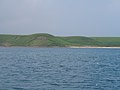
 A landscape picture of Siyu (Xiyu) Township, Taiwan.jpg 2,848 × 2,136; 1.44 MB
-
 Dream Beach in penghu.jpg 4,032 × 3,024; 2.95 MB
-
 Niuxinshan.JPG 1,600 × 1,200; 346 KB
-
 PENGHU+EMILYLIU+3.jpg 5,306 × 3,537; 10.39 MB
-
 Sió-mn̂g-sū Keng-hî-tōng Tē-chit Kong-hn̂g 20210421.jpg 4,608 × 2,592; 6.1 MB
-
 Ticket booth at the Xiyu West Fort Visitor Center.jpg 3,264 × 2,448; 1.96 MB
-
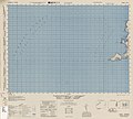 Txu-pclmaps-oclc-6550512-gaian-1917-i.jpg 4,638 × 4,176; 3.31 MB
-
 Txu-pclmaps-oclc-6550512-mako-2017-iv.jpg 4,693 × 4,185; 4.77 MB
-
 Yuweng Island.jpg 795 × 280; 33 KB
-
 二崁聚落古厝的屋頂.jpg 5,184 × 3,456; 7.24 MB
-
 內垵遊憩區 - panoramio (1).jpg 2,848 × 2,136; 1.47 MB
-
 內垵遊憩區 - panoramio.jpg 2,848 × 2,136; 1.45 MB
-
 合界后螺合院.jpg 3,248 × 2,432; 2.18 MB
-
 外蹔地標 - panoramio.jpg 2,848 × 2,136; 1.44 MB
-
 大目船擬作.jpg 3,264 × 2,448; 1.75 MB
-
 大菓葉安檢所 (3).jpg 3,248 × 2,432; 3.33 MB
-
 大菓葉漁港、玄武岩、安檢所.jpg 3,248 × 2,432; 3.08 MB
-
 小池角空照圖 Aerial photographs of Hsiaochijiao village.jpg 5,472 × 3,648; 4.93 MB
-
 小門菜宅 01.jpg 3,248 × 2,432; 5.05 MB
-
 小門菜宅 02.jpg 3,248 × 2,432; 5.33 MB
-
 小門菜宅 03.jpg 3,248 × 2,432; 4.84 MB
-
 日軍攻佔澎湖漁翁島.jpg 1,641 × 1,345; 543 KB
-
 柱狀玄武岩.jpg 3,024 × 4,032; 3.46 MB
-
 清心飲食店 01.jpg 4,032 × 3,024; 2.59 MB
-
 清心飲食店 02.jpg 4,032 × 3,024; 1.21 MB
-
 澎湖灣:大菓葉漁港 (1).jpg 3,248 × 2,432; 2.83 MB
-
 澎湖灣:大菓葉漁港 (2).jpg 3,248 × 2,432; 3.12 MB
-
 澎湖灣:大菓葉漁港 (3).jpg 3,248 × 2,432; 3 MB
-
 澎湖縣第19屆議員: 李添進.jpg 1,528 × 2,464; 1.76 MB
-
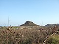 牛心山 - panoramio.jpg 2,848 × 2,136; 1.45 MB
-
 赤馬社區 - panoramio.jpg 2,848 × 2,136; 1.58 MB
-
 赤馬空照圖 Aerial photographs of Chima village.jpg 5,472 × 3,648; 4.15 MB
.jpg)
.jpg)
.jpg)
_Township,_Taiwan.jpg)


.jpg)


.jpg)


.jpg)
.jpg)
.jpg)


