Category:Slavětín (Olomouc District)
Jump to navigation
Jump to search
village in Olomouc District of Olomouc region  Pohled na obec ze západu   | |||||
| Upload media | |||||
| Instance of | |||||
|---|---|---|---|---|---|
| Location |
| ||||
| Population |
| ||||
| Area |
| ||||
| Elevation above sea level |
| ||||
| official website | |||||
 | |||||
Subcategories
This category has only the following subcategory.
Media in category "Slavětín (Olomouc District)"
The following 16 files are in this category, out of 16 total.
-
 Flag of Slavětín OL.jpg 746 × 500; 41 KB
-
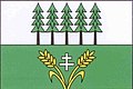
 Coat of arms of Slavětín OL.jpg 443 × 500; 39 KB
-
 Hradečka, Slavětín, okres Olomouc.jpg 2,014 × 3,038; 4.41 MB
-
 Kříž na návsi, Slavětín, okres Olomouc.jpg 2,014 × 3,038; 3.45 MB
-
 Kříž u silnice v severní části obce, Slavětín, okres Olomouc.jpg 2,014 × 3,038; 3.94 MB
-
 Náves, Slavětín, okres Olomouc.jpg 3,038 × 2,014; 2.72 MB
-
 Obecní úřad, Slavětín, okres Olomouc.jpg 2,014 × 3,038; 3.63 MB
-
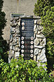 Památník obětem světových válek, Slavětín, okres Olomouc.jpg 2,014 × 3,038; 4.66 MB
-
 Panoramatický pohled na Slavětín, Ješov a Hanou, okres Olomouc.jpg 8,087 × 1,657; 17.07 MB
-
 Pohled na obec ze západu, Slavětín, okres Olomouc.jpg 3,038 × 2,014; 3.25 MB
-
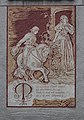
 Slavětín čp. 11 sgrafito 01.jpg 4,000 × 6,000; 12.08 MB
-
 Slavětín čp. 11 sgrafito 02.jpg 6,000 × 4,000; 14.75 MB
-
 Slavětín čp. 11 sgrafito 03.jpg 3,504 × 5,696; 14.1 MB
-
 Slavětín čp. 56 sgrafito 01.jpg 3,744 × 5,360; 13.1 MB
-
 Slavětín čp. 60 sgrafito 01.jpg 3,856 × 5,424; 13.3 MB
-
 Škola, Slavětín, okres Olomouc.jpg 2,014 × 3,038; 3.37 MB


