Category:Soil pollution
跳转到导航
跳转到搜索
pollution of land by human-made chemicals or other alteration  Halogiad pridd a achoswyd gan danciau storio tanddaearol yn cynnwys tar. | |||||
| 上传媒体 | |||||
| 上级分类 | |||||
|---|---|---|---|---|---|
| 位置 | 土壤 | ||||
| |||||
分类“Soil pollution”中的媒体文件
以下63个文件属于本分类,共63个文件。
-
 20180221-OSEC-LSC-0021 (39518134715).jpg 5,504 × 8,256;44.75 MB
-
 20180221-OSEC-LSC-0025 (39518132955).jpg 5,504 × 8,256;28.14 MB
-
 20180221-OSEC-LSC-0029 (39518131555).jpg 8,256 × 5,504;26.5 MB
-
 20180221-OSEC-LSC-0035 (39518130515).jpg 5,504 × 8,256;21.89 MB
-
 20180221-OSEC-LSC-0042 (39518130015).jpg 8,256 × 5,504;31.61 MB
-
 20180221-OSEC-LSC-0055 (39518128545).jpg 8,256 × 5,504;33.99 MB
-
 20180221-OSEC-LSC-0056 (39518126925).jpg 8,256 × 5,504;28.03 MB
-
 20180221-OSEC-LSC-0078 (39518125235).jpg 8,256 × 5,504;33.09 MB
-
 20180221-OSEC-LSC-0082 (26543390418).jpg 8,256 × 5,504;33.41 MB
-
 20180221-OSEC-LSC-0085 (26543388258).jpg 5,504 × 8,256;40.31 MB
-
 2019 0211 Fueling diesel locomotive Korat train station.jpg 3,870 × 2,580;3.09 MB
-
 Abstract Pollution 1997.jpg 3,904 × 2,448;6.38 MB
-
 Agressão da mata do Iguatemí por atividades antrópicas.jpg 1,682 × 1,134;1.94 MB
-
 Arsenforurenet jord på collstropgrunden i Brabrand, 2010-09-30.jpg 3,648 × 2,736;1.98 MB
-
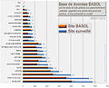 BASOL Sols pollués france.jpg 760 × 612;99 KB
-
 Bille Shrapnel surface et profondeur Verdun.jpg 1,274 × 658;118 KB
-
 Bruin-lagoon-drilling.jpg 1,500 × 1,000;247 KB
-
-
 Canjuers poubelles 2521.jpg 2,048 × 1,536;1.14 MB
-

-
 CuPollutionEuropa2024.jpg 1,618 × 886;363 KB
-
 Degradación del suelo.jpg 1,388 × 1,016;294 KB
-
 Dortmund - Emscherallee - Kokerei Hansa Sanierung (Deusenberg) 01 ies.jpg 5,616 × 3,744;21.39 MB
-
 Dortmund - Emscherallee - Kokerei Hansa Sanierung (Deusenberg) 02 ies.jpg 5,616 × 3,744;20.01 MB
-
 Dortmund - Emscherallee - Kokerei Hansa Sanierung (Deusenberg) 03 ies.jpg 5,616 × 3,744;21.38 MB
-

-
 Ecological pollution.jpg 720 × 1,280;359 KB
-
 Es water cont.png 450 × 228;183 KB
-

-
 Exhausted battery.JPG 2,272 × 1,704;1.24 MB
-
 Fort-greely-low-level-waste.jpg 720 × 540;179 KB
-
 Fukushima 20201102 114146.jpg 4,608 × 2,592;2.17 MB
-
 Fukushima 20201102 115151.jpg 4,608 × 2,592;1.86 MB
-
 Impacto do ser humano sobre a natureza.jpg 1,698 × 1,180;1.62 MB
-
 Just a puddle .. (1312494147).jpg 1,600 × 1,200;584 KB
-
 Nrborderborderentrythreecolorsmay05-1-.JPG 640 × 480;91 KB
-
 SOIL LEACHED AND DISCOLORED BY DUMPED COAL SLAG NEAR CADIZ OHIO - NARA - 555598.jpg 2,037 × 3,000;1.14 MB
-
 Orphan Mine, Grand Canyon National Park.jpg 1,800 × 1,200;769 KB
-
 PFT-belastete Fläche Scharfenberg Behandlungsanlage.jpg 2,816 × 2,112;2.82 MB
-
 PFT-belastete Fläche Scharfenberg Drainage.jpg 2,816 × 2,112;1.47 MB
-
 PFT-belastete Fläche Scharfenberg.jpg 2,816 × 2,112;2.12 MB
-
 Plume pollution.svg 591 × 326;11 KB
-
 PollutantConcentration.png 2,717 × 2,143;4.02 MB
-
 Polluted estuary.jpg 4,000 × 3,000;8 MB
-
 Pollution sols UE causes.jpg 2,584 × 1,828;494 KB
-
-
 Redstone Airfield land cleanup 57.jpg 680 × 539;53 KB
-

-
 Sanierte Fläche in Rüthen 1.jpg 2,640 × 1,983;1.57 MB
-
 Sanierte Fläche in Rüthen 2.jpg 2,745 × 2,059;1.68 MB
-
 Seattle - land use notice on 6th Ave W at W Ewing St.jpg 4,288 × 2,848;6.47 MB
-
 Sediment trap EPA.jpg 299 × 210;47 KB
-
 Shadow on plowed field in Poland.jpg 6,016 × 4,000;3.45 MB
-
 Soil contamination warning sign in Verkkosaari, Helsinki, Finland, 2021.jpg 11,523 × 8,642;56.8 MB
-
 Soil pollution imugbiebdi.jpg 5,184 × 3,456;6.06 MB
-
 Soil pollution.jpg 1,024 × 576;297 KB
-
 Soil-pollution.jpg 3,024 × 4,032;4.47 MB
-
 Soilcontam.JPG 1,632 × 1,224;392 KB
-
 Tanah terbiar di Bandar Baru Bangi.jpg 2,592 × 1,944;1.54 MB
-
 Toxicity of firecracker and firework.png 1,000 × 600;85 KB
-
 Waukegan harbor superfund.svg 1,212 × 2,158;67 KB
-
 Mine Engine House near Medlyn - geograph.org.uk - 193041.jpg 640 × 426;107 KB
-
 燃煙花爆竹之害.png 1,000 × 600;96 KB
.jpg)
.jpg)
.jpg)
.jpg)
.jpg)
.jpg)
.jpg)
.jpg)
.jpg)
.jpg)


_01_ies.jpg)
_02_ies.jpg)
_03_ies.jpg)
_01_ies.jpg)


.jpg)


