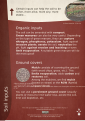
Category:Soils
Jump to navigation
Jump to search
- (en) Soil
- (ar) تربة (زراعة)
- (ay) Laq'a
- (az) Torpaq
- (bat-smg) Dėrva
- (be) Глеба
- (bg) Почва
- (bn) মৃত্তিকা
- (bs) Tlo
- (ca) Sòl
- (cs) Půda (pedologie)
- (cy) Pridd
- (da) Jord
- (de) Boden (Bodenkunde)
- (el) Έδαφος
- (eo) Grundo
- (es) Suelo
- (et) Muld
- (eu) Lurzoru
- (fa) خاک
- (fi) Maalaji
- (fr) Sol (pédologie)
- (gd) Ùir
- (gl) Solo
- (he) קרקע
- (hr) Tlo
- (hu) Talaj
- (id) Tanah
- (is) Jarðvegur
- (it) Suolo
- (ja) 土壌
- (ka) ნიადაგი
- (kk) Жер
- (ko) 흙
- (lt) Dirvožemis
- (lv) Augsne
- (mk) Почва
- (ml) മണ്ണ്
- (mr) माती
- (ms) Tanah
- (nah) Tlālpantli
- (nl) Bodem
- (nn) Jord
- (no) Jord
- (pl) Gleba
- (pt) Solo
- (qu) Allpa
- (ro) Sol (strat al Pământului)
- (ru) Почва
- (scn) Tirrinu
- (sh) Tlo
- (simple) Soil
- (sk) Pôda
- (sl) Prst (pedologija)
- (sr) Едафски фактори
- (sv) Jord (mark)
- (ta) மண்
- (tg) Гил
- (th) ดิน
- (tl) Lupa
- (tr) Toprak
- (uk) Ґрунти
- (vi) Đất
- (yi) באדן
- (zh) 土壤
- (zh-min-nan) Thô͘
Deutsch: Erdboden
Français : Sols
日本語: 土壌, 土
Polski: Gleba
தமிழ்: மண்
Deutsch: Boden, auch Erdboden
English: Soil is a natural body consisting of layers of mineral constituents of variable thicknesses, which differ from the parent materials in their morphological, physical, chemical, and mineralogical characteristics
natural body consisting of layers that are primarily composed of minerals  | |||||
| Upload media | |||||
| Subclass of |
| ||||
|---|---|---|---|---|---|
| Part of | |||||
| Has part(s) |
| ||||
| Different from | |||||
| Said to be the same as | Pinnas, Q12822739 | ||||
| |||||
Subcategories
This category has the following 60 subcategories, out of 60 total.
*
+
?
- Unidentified soils (73 F)
A
B
C
D
E
- Earthworks (engineering) (empty)
F
- Fluidized soils (1 F)
G
H
I
- Imogolite (5 F)
L
M
- Machair (61 F)
O
P
R
S
- Silt loam (2 F)
- Soil sealing (3 F)
- Soil-stained food (7 F)
- Soil Stories (30 F)
- Soil structure (30 F)
T
- Takir (13 F)
U
Media in category "Soils"
The following 200 files are in this category, out of 632 total.
(previous page) (next page)-
De-Erde3.ogg 1.7 s; 17 KB
-
 -2018-08-30 Four Tons of Top soil, Norfolk, England.JPG 5,152 × 3,864; 6.57 MB
-

-
 5.díl html 26fb8b62.png 664 × 334; 356 KB
-
 A treatise on rocks, rock-weathering and soils; (1913) (20189071123).jpg 4,192 × 2,364; 2.87 MB
-
 A treatise on rocks, rock-weathering and soils; (1913) (20189083023).jpg 2,676 × 3,960; 2.63 MB
-
 A treatise on rocks, rock-weathering and soils; (1913) (20189154803).jpg 2,564 × 4,246; 2.49 MB
-
 A treatise on rocks, rock-weathering and soils; (1913) (20189173003).jpg 3,984 × 2,446; 2.91 MB
-
 A treatise on rocks, rock-weathering and soils; (1913) (20189205353).jpg 3,304 × 2,358; 2.61 MB
-
 A treatise on rocks, rock-weathering and soils; (1913) (20622075360).jpg 3,512 × 2,758; 3.31 MB
-
 A treatise on rocks, rock-weathering and soils; (1913) (20622123330).jpg 2,714 × 3,246; 2.9 MB
-
 A treatise on rocks, rock-weathering and soils; (1913) (20622131028).jpg 2,800 × 2,614; 2.49 MB
-
 A treatise on rocks, rock-weathering and soils; (1913) (20622133290).jpg 3,464 × 2,750; 3.11 MB
-
 A treatise on rocks, rock-weathering and soils; (1913) (20800635542).jpg 2,822 × 1,972; 1.6 MB
-
 A treatise on rocks, rock-weathering and soils; (1913) (20800673952).jpg 4,136 × 2,742; 3.74 MB
-
 A treatise on rocks, rock-weathering and soils; (1913) (20800703432).jpg 3,568 × 2,732; 3.02 MB
-
 A treatise on rocks, rock-weathering and soils; (1913) (20817233371).jpg 3,032 × 4,386; 4.26 MB
-

-

-

-

-
 A wiggly worm in the dirt.jpg 1,592 × 1,672; 1.28 MB
-

-

-
 Alphasoil-06 Katalysator.jpg 2,304 × 3,072; 874 KB
-
 Alpine permafrost in Scandinavia 08.jpg 682 × 696; 100 KB
-
 Anjon pic-1 (54).JPG 4,608 × 3,456; 5.44 MB
-
 Ant and soil.jpg 4,000 × 2,250; 4.59 MB
-
 Análise física do solo.jpg 3,328 × 1,872; 978 KB
-
 Apb thick o horizon.jpg 1,950 × 1,600; 2.22 MB
-
 Arbeiders maken akkers vrij van stenen bij kibboets Ein Gidi, Bestanddeelnr 255-2734.jpg 2,614 × 2,664; 1.16 MB
-
 Arbeiders maken akkers vrij van stenen bij kibboets Ein Gidi, Bestanddeelnr 255-2735.jpg 2,611 × 2,637; 1.16 MB
-
 ASSHTO.png 646 × 335; 73 KB
-
 Augne gneiss soil.jpg 1,200 × 1,820; 475 KB
-
 B1e1fb1e76c7f8206d20bdd2a0d2f20e(1).jpg 2,496 × 1,664; 2.89 MB
-
 Balsa en desuso por el riego por goteo.JPG 1,024 × 768; 261 KB
-
 Baltic Sea's eroded coast.jpg 1,536 × 2,048; 1.31 MB
-
 Banialiwaheez.jpg 958 × 1,192; 150 KB
-
 Base library renovations 160616-F-UP124-070.jpg 2,100 × 1,500; 985 KB
-
 Basic soil types diagram.svg 951 × 629; 870 KB
-
 Begin Road, Tel Aviv-Yafo דרך מנחם בגין (24).JPG 2,880 × 4,320; 4.12 MB
-
 Begin Road, Tel Aviv-Yafo דרך מנחם בגין (45).JPG 4,320 × 2,880; 4.99 MB
-
 Begin Road, Tel Aviv-Yafo דרך מנחם בגין (46).JPG 4,320 × 2,880; 5.23 MB
-
 Begin Road, Tel Aviv-Yafo דרך מנחם בגין (48).JPG 4,320 × 2,880; 5.15 MB
-
 Begin Road, Tel Aviv-Yafo דרך מנחם בגין (49).JPG 4,320 × 2,880; 5.1 MB
-
 Bend in the River Ashop - geograph.org.uk - 155858.jpg 640 × 480; 117 KB
-
 Better growth requires perfect sunshine.jpg 3,024 × 4,032; 2.1 MB
-
 Bevloeiingswerken in Galilea Door droogte gebarsten aarde, Bestanddeelnr 255-4808.jpg 2,629 × 2,637; 1.13 MB
-

-

-

-
 Bevloeiingswerken in Galilea Een man op een tractor met sproeiwagen, Bestanddeelnr 255-4809.jpg 2,623 × 2,649; 1,020 KB
-
 Bevloeiingswerken in Galilea Waterpomp voor sproeiinstallaties, Bestanddeelnr 255-4816.jpg 2,632 × 2,649; 1,017 KB
-
 Bij de Dode Zee panorama vanaf de zuidoostelijke oever, Bestanddeelnr 255-9248.jpg 2,623 × 2,643; 1.04 MB
-
 Bij de Dode Zee panorama vanaf de zuidoostelijke oever, Bestanddeelnr 255-9249.jpg 2,608 × 2,646; 922 KB
-
 BissauPolders.jpg 553 × 359; 62 KB
-
 Bohlwand.jpg 2,976 × 2,976; 3.15 MB
-
 Braunerderanker.jpg 2,048 × 1,536; 706 KB
-
 Brodelböden 3.jpg 567 × 454; 73 KB
-
 Brodovin cultivated landscape.jpg 6,240 × 4,160; 12.17 MB
-
 BrownSoil.jpg 352 × 500; 36 KB
-
 Caliche (Ash Hollow Formation, Miocene, ~10-12 Ma; Ashfall Fossil Beds, Nebraska, USA) 2.jpg 2,306 × 2,000; 3.52 MB
-
 Chemin du Bois de Halle - panoramio (1).jpg 3,456 × 2,592; 3.86 MB
-
 Chemin du Bois de Halle - panoramio.jpg 4,912 × 1,080; 2.3 MB
-
 Clay Coating1.jpg 700 × 520; 122 KB
-
 Clay Soil.jpg 2,592 × 1,456; 2.2 MB
-
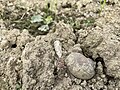
 Clod from Wastewater.jpg 3,264 × 2,448; 962 KB
-
 CNR (IPSP) 07.jpg 4,288 × 2,848; 5.18 MB
-
 Coarse grained,quartz.jpg 4,608 × 2,304; 5.21 MB
-
 Coleta indeformada de solo.jpg 717 × 1,274; 281 KB
-
-
 Components of Soil Pie Chart.png 1,080 × 1,278; 96 KB
-
 Composició ideal d'un sòl franc.png 1,410 × 1,819; 195 KB
-
 Compost avec lombric.jpg 3,840 × 1,836; 1.58 MB
-
 Cover crops in Northwestern South Dakota 2015 (20115558362).jpg 3,968 × 2,976; 5.78 MB
-
 Cracked dry soil Aceredo.jpg 4,288 × 2,854; 3.18 MB
-
 Cracked earth.png 750 × 1,334; 5.7 MB
-
 Crosta superficial.jpg 640 × 480; 151 KB
-
 Cutivated land in Brodovin.jpg 6,240 × 4,160; 13.66 MB
-
-
-
 Devon Culm Subsoil - geograph.org.uk - 344702.jpg 640 × 640; 153 KB
-
 Digging in permafrost.jpg 2,816 × 2,112; 1.18 MB
-
 Dirt and Mud 002 - Loose Dirt with Plants.jpg 5,184 × 3,456; 8.89 MB
-
 Dirt and Mud 003 - Muddy Water.jpg 5,184 × 3,456; 6.31 MB
-
 Dirt and Mud 004 - Muddy Water.jpg 5,184 × 3,456; 6.09 MB
-
 Dirt and Mud 005 - Muddy Water.jpg 5,184 × 3,456; 7.53 MB
-
 Dirt and Mud 008 - Mud.jpg 5,184 × 3,456; 8.46 MB
-
 Dirt pile.jpg 640 × 480; 140 KB
-
 Dirt.jpg 4,608 × 3,072; 4.13 MB
-
 Dromedaris in de woestijn bij de Dode Zee, Bestanddeelnr 255-2717.jpg 2,596 × 2,661; 983 KB
-
 Drought bshsjd.jpg 3,456 × 5,184; 5.93 MB
-
 Drummer Soil Series - From USDA NRCS.jpg 423 × 636; 69 KB
-
-
 Earth (Background focused).jpg 5,312 × 2,988; 5.43 MB
-
 Earth 3.jpg 5,312 × 2,988; 5.68 MB
-

-
 Earth piles.JPG 2,048 × 1,536; 1.33 MB
-
 Earth Soil and Water.jpg 4,608 × 3,456; 3.96 MB
-
 Earth-3289810 1280.jpg 1,280 × 682; 319 KB
-
 Earthhero.jpg 465 × 287; 58 KB
-
 Eating Dirt (3009282976).jpg 4,272 × 2,848; 3.97 MB
-

-
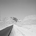 Een weg naar Massada., Bestanddeelnr 255-2720.jpg 2,572 × 2,643; 817 KB
-

-

-
 Ein Gidi Rotslandschap met enkele palmbomen, Bestanddeelnr 255-2751.jpg 2,587 × 2,640; 1.22 MB
-
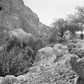 Ein Gidi Rotslandschap met hier en daar begroeiing, Bestanddeelnr 255-2749.jpg 2,638 × 2,643; 1.25 MB
-
-
 Erdboden grün gerissen W.jpg 3,072 × 2,304; 7.42 MB
-
 Eroded soils in Iowa.png 2,100 × 1,500; 3.7 MB
-
 Erosion.jpg 1,769 × 2,670; 2.72 MB
-
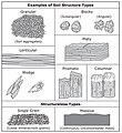 Examples of Soil Structure Types.jpg 683 × 745; 131 KB
-
 Exhibition garden (png) 1.png 1,169 × 1,654; 1.91 MB
-
 Exhibition garden (png) 2.png 1,169 × 1,654; 1.71 MB
-
 Exhibition garden (png) 3.png 1,169 × 1,654; 1.69 MB
-
 Exhibition garden (png) 4.png 1,169 × 1,654; 1.82 MB
-
 Exhibition garden (png) 5.png 1,169 × 1,654; 1.89 MB
-
 Exhibition garden (png) 6.png 1,169 × 1,654; 1.75 MB
-
 Exhibition garden 1.svg 1,052 × 1,488; 3.89 MB
-
 Exhibition garden 2.svg 1,052 × 1,488; 3.44 MB
-
 Exhibition garden 3.svg 1,052 × 1,488; 8.81 MB
-
 Exhibition garden 4.svg 1,052 × 1,488; 4.29 MB
-
 Exhibition garden 5.svg 1,052 × 1,488; 7.04 MB
-
 Exhibition garden 6.svg 1,052 × 1,488; 4.1 MB
-
 Exposition jardin et sol (png) 1.png 1,169 × 1,654; 1.94 MB
-
 Exposition jardin et sol (png) 2.png 1,169 × 1,654; 1.72 MB
-
 Exposition jardin et sol (png) 3.png 1,169 × 1,654; 1.74 MB
-
 Exposition jardin et sol (png) 4.png 1,169 × 1,654; 1.86 MB
-
 Exposition jardin et sol (png) 5.png 1,169 × 1,654; 1.91 MB
-
 Exposition jardin et sol (png) 6.png 1,169 × 1,654; 1.81 MB
-
 Exposition jardin et sol 1.svg 1,052 × 1,488; 3.89 MB
-
 Exposition jardin et sol 2.svg 1,052 × 1,488; 3.44 MB
-
 Exposition jardin et sol 3.svg 1,052 × 1,488; 8.81 MB
-
 Exposition jardin et sol 4.svg 1,052 × 1,488; 4.29 MB
-
 Exposition jardin et sol 5.svg 1,052 × 1,488; 7.04 MB
-
 Exposition jardin et sol 6.svg 1,052 × 1,488; 4.1 MB
-
 F Vassjuk jort på Toten.jpg 5,472 × 3,648; 5.08 MB
-
 Faktisk.jpg 3,000 × 4,000; 2.52 MB
-
 Farmers's land.jpg 2,322 × 4,128; 5.49 MB
-
 FaserbueschelimTorf.jpg 2,048 × 1,536; 408 KB
-
 Fates of soil CO2.png 1,043 × 829; 152 KB
-
 Field soil sampling.jpg 1,024 × 768; 187 KB
-
 Fixing a waterpipe (13151813085).jpg 3,972 × 2,832; 6.07 MB
-
 Fizičke osobine.jpg 2,048 × 1,536; 1.43 MB
-
 Flugsand-Regosol.jpg 1,644 × 1,068; 416 KB
-
 FM-5-33-Terrain-Analysis.pdf 1,247 × 1,625, 205 pages; 3.68 MB
-
 Fractal pattern (2485773707).jpg 2,048 × 1,536; 1.66 MB
-
 Frossen svartjord på Toten.jpg 5,472 × 3,648; 9.49 MB
-
 Frost-columns-1.jpg 1,799 × 3,200; 3.66 MB
-
 Frostiger Morgen Tromm Hessen 2011.JPG 2,736 × 3,648; 4.5 MB
-
 Fungi on wet soil by sankar.jpg 4,096 × 2,304; 4.12 MB
-
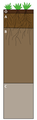 Generalized Soil Profile.png 219 × 712; 42 KB
-
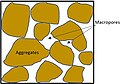 Geometry of macropores.jpg 334 × 233; 27 KB
-
 GettingDeepWikipediaPhoto.jpg 720 × 960; 159 KB
-
 Gezicht op de Dode Zee met het rondom gelegen gebergte, Bestanddeelnr 255-2683.jpg 2,572 × 2,646; 1.01 MB
-
 Gezicht op de kibboets Ein Gidi, Bestanddeelnr 255-2730.jpg 2,611 × 2,667; 1.09 MB
-

-
 Gezicht op een berglandschap bij Ein Gidi, Bestanddeelnr 255-2729.jpg 2,620 × 2,655; 1.04 MB
-

-
 Good earth.jpg 3,920 × 2,204; 2.86 MB
-
 Granulite soil.jpg 1,200 × 1,820; 399 KB
-
 Gras und Erde aus der Bodenperspektive.jpg 2,592 × 1,944; 1.11 MB
-
 Grfsoil.JPG 3,456 × 2,592; 4.23 MB
-
 Grietas.jpg 3,072 × 2,304; 1.37 MB
-

-
 Gully erosion in Gombe 01.jpg 3,456 × 4,608; 4.4 MB
-
 Gully erosion in Gombe 02.jpg 3,456 × 4,608; 4.8 MB
-
 Gully erosion in Gombe 03.jpg 4,608 × 3,456; 2.8 MB
-
 Gully erosion in Gombe 04.jpg 4,608 × 3,456; 2.89 MB
-
 Gully erosion in Gombe 05.jpg 4,608 × 3,456; 1.9 MB
-
 Gully erosion in Gombe 06.jpg 4,608 × 3,456; 2.48 MB
-
 Gully erosion in Gombe 07.jpg 4,608 × 3,456; 3.75 MB
-
 Gully erosion in Gombe 08.jpg 3,456 × 4,608; 3.63 MB
-
 Gully erosion in Gombe 09.jpg 3,456 × 4,608; 2.94 MB
-
 Gully erosion in Gombe 10.jpg 3,456 × 4,608; 4.11 MB
-
 Hardpan.jpg 400 × 300; 57 KB
-
 Harney soil profile (Kansas State Soil).png 401 × 593; 322 KB
-
 Hassan zoumen.jpg 1,690 × 902; 1.05 MB
-
 Hayman Fire (4).jpg 2,048 × 1,536; 686 KB
-
 Hemijske osobine.jpg 420 × 312; 59 KB
-
 HisticEpipedon2.JPG 721 × 448; 91 KB
-
 Holdrege soil.PNG 514 × 780; 802 KB
-
 Horizonti zemljišta.gif 590 × 1,300; 443 KB
-
 Hot Weather 1.jpg 4,128 × 2,322; 7.57 MB
-
 How the memorial tree is planted with the Pedoné Box.png 452 × 487; 189 KB
-
 Howz-e Soltan (14).jpg 3,000 × 2,000; 5.26 MB
-
 Howz-e Soltan (16).jpg 3,000 × 2,000; 5.16 MB
-
 Howz-e Soltan (6).jpg 3,000 × 2,250; 5.41 MB
-
 Hromada hlíny západně od zastávky Přeštická.jpg 2,592 × 1,944; 2.63 MB
-
 Humic Luvisols. Сірі опідзолені грунти.JPG 1,488 × 3,743; 1.97 MB
-
 Humus fj.jpg 366 × 400; 46 KB
-
 Humusleaves.jpg 3,120 × 4,160; 2.76 MB
-
 Hydrosol in north Qld Ingham–Cardwell area.jpg 421 × 790; 121 KB
-
 Ice wedge pseudomorph.jpg 800 × 1,066; 251 KB
-

-
 Iron rich soil (3254934957).jpg 2,048 × 1,536; 771 KB
-
 Iron rich soil (3255764846).jpg 2,048 × 1,536; 1.5 MB
-
 Jornada G-IBPE soil pit horizons.jpg 1,432 × 1,072; 297 KB
-
 Kagbeni, Mustang 04.jpg 5,992 × 3,371; 23.21 MB


_(20189071123).jpg)
_(20189083023).jpg)
_(20189154803).jpg)
_(20189173003).jpg)
_(20189205353).jpg)
_(20622075360).jpg)
_(20622123330).jpg)
_(20622131028).jpg)
_(20622133290).jpg)
_(20800635542).jpg)
_(20800673952).jpg)
_(20800703432).jpg)
_(20817233371).jpg)
_LOC_matpc.19988.jpg)
_view_with_men_%26_camels_of_the_camel_corps_in_the_foreground_LOC_matpc.19969.jpg)


,_Jordan_R._(i.e.,_River),_Amman_LOC_matpc.13652.jpg)


.JPG)


.jpg)


.JPG)
.JPG)
.JPG)
.JPG)
.JPG)


_2.jpg)
.jpg)


_07.jpg)


_(20045969913).jpg)


.jpg)


.jpg)


.jpg)


_1.png)
_2.png)
_3.png)
_4.png)
_5.png)
_6.png)


_1.png)
_2.png)
_3.png)
_4.png)
_5.png)
_6.png)


.jpg)


.jpg)


_aan_de_oever_van_de_Dode_Zee,_Bestanddeelnr_255-2684.jpg)


.png)

.jpg)


.jpg)
.jpg)
.jpg)


.jpg)
.jpg)


.jpg)
_buried_in_soil,_rural_areas_of_Hunan,_China.jpg)