Category:Sophia's Burg
Jump to navigation
Jump to search
| Object location | | View all coordinates using: OpenStreetMap |
|---|
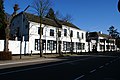
house in Vught, Netherlands  | |||||
| Upload media | |||||
| Instance of | |||||
|---|---|---|---|---|---|
| Location | Vught, North Brabant, Netherlands | ||||
| Street address |
| ||||
| Located on street |
| ||||
| Heritage designation |
| ||||
 | |||||
|
This is a category about rijksmonument number 38166
|
| Address |
|
Media in category "Sophia's Burg"
The following 22 files are in this category, out of 22 total.
-
 Achtergevel en koetshuis - Vught - 20247914 - RCE.jpg 1,200 × 959; 232 KB
-
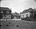
 Huis en koetshuis vanuit de tuin - Vught - 20247913 - RCE.jpg 1,200 × 959; 247 KB
-
 Inrijpoort straatzijde - Vught - 20247912 - RCE.jpg 959 × 1,200; 245 KB
-
 Naar het zuiden gezien - Vught - 20247909 - RCE.jpg 1,200 × 1,172; 276 KB
-
 Naar het zuiden gezien - Vught - 20247918 - RCE.jpg 1,200 × 1,198; 351 KB
-

-
 Schoorsteen kamer begane grond - Vught - 20247916 - RCE.jpg 1,200 × 959; 233 KB
-
 Schoorsteen kamer begane grond - Vught - 20247917 - RCE.jpg 959 × 1,200; 191 KB
-
 Sophia's Burg - Vught 01.JPG 3,617 × 2,863; 2.96 MB
-
 Sophia's Burg - Vught 02.JPG 3,556 × 2,569; 2.34 MB
-
 Sophia's Burg - Vught 03.JPG 3,887 × 2,884; 3.01 MB
-
 Sophia's Burg - Vught 04.JPG 4,000 × 3,000; 2.7 MB
-
 Sophia's Burg - Vught 05.JPG 3,650 × 2,947; 2.46 MB
-
 Sophia's Burg 2.jpg 3,008 × 2,000; 5.25 MB
-
 Sophia's burg rechterdeel.jpg 3,008 × 2,000; 5.45 MB
-
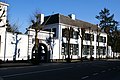
 Sophia'sburg, voorgevel met poort - Vught - 20247911 - RCE.jpg 1,200 × 959; 189 KB
-
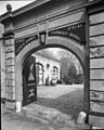
 Sophiaburg (toegangspoort) - Vught - 20247920 - RCE.jpg 1,200 × 1,179; 304 KB
-
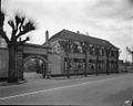
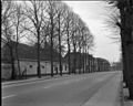 Straatoverzicht - Vught - 20247905 - RCE.jpg 1,200 × 959; 298 KB
-
-
 Vanaf (Sophiaburg) naar het noorden gezien - Vught - 20247919 - RCE.jpg 1,200 × 1,195; 368 KB
-
 Verdieping - Vught - 20247910 - RCE.jpg 959 × 1,200; 155 KB
-
 Zijgevel aan straat - Vught - 20511973 - RCE.jpg 1,200 × 953; 102 KB


_-_Vught_-_20247920_-_RCE.jpg)


_naar_het_noorden_gezien_-_Vught_-_20247919_-_RCE.jpg)

