Category:Sorn, East Ayrshire
Jump to navigation
Jump to search
village in East Ayrshire, Scotland, UK  | |||||
| Upload media | |||||
| Instance of | |||||
|---|---|---|---|---|---|
| Location |
| ||||
 | |||||

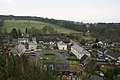
English: Sorn is a small village in East Ayrshire, Scotland. It is situated on the River Ayr. It has a population of roughly 350. Local services include: a pub, a church, a general store, a motorbike shop and a television shop. There is also a village hall and a bowling green and primary school.
Subcategories
This category has the following 16 subcategories, out of 16 total.
A
B
- Blairmulloch Farm (4 F)
- Burn o' Need Rig (5 F)
- Burntshield Farm (3 F)
D
- Dykeneuk, East Ayrshire (3 F)
H
- High Brocklar (4 F)
- Holehouse Mill (13 F)
L
N
S
T
W
- Weitshaw Muir (3 F)
Media in category "Sorn, East Ayrshire"
The following 75 files are in this category, out of 75 total.
-
 Afforestation - geograph.org.uk - 342995.jpg 640 × 426; 64 KB
-
 Beech trees at Sorn Woods, East Ayrshire.jpg 4,064 × 2,740; 3.9 MB
-
 Bridge and boardwalk on the River Ayr Way - geograph.org.uk - 519616.jpg 640 × 480; 129 KB
-
 Burr on Scots Pine, Sorn Woods, East Ayrshire.jpg 3,625 × 2,647; 2.41 MB
-
 Cleuch Burn Road Bridge, Sorn - geograph.org.uk - 337231.jpg 426 × 639; 242 KB
-
 Corylus avellana showing secondary stems. Holehouse Holm, River Ayr, East Ayrshire.jpg 3,723 × 2,739; 2.65 MB
-
 Council Housing, Sorn, East Ayrshire.jpg 640 × 426; 71 KB
-
 Dalgain - geograph.org.uk - 337239.jpg 640 × 426; 61 KB
-
 Dalgain Farm, Sorn, East Ayrshire.jpg 4,875 × 2,066; 2.11 MB
-
 Dalgain Lime Works - geograph.org.uk - 519600.jpg 640 × 480; 154 KB
-
 Dalgain Lime Works and coal mine, River Ayr, Sorn, East Ayrshire.jpg 4,896 × 2,752; 5.86 MB
-
 Dalgain Lime Works, Holhouse Holm, Sorn, East Ayrshire.jpg 4,896 × 2,752; 6.25 MB
-
 Entrance to Sorn Mains - geograph.org.uk - 342475.jpg 640 × 427; 130 KB
-
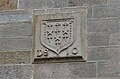
 Farquhar Coat of arms - Gilmilnscroft House , Sorn, East Ayrshire.jpg 3,643 × 2,740; 2.43 MB
-
 Foxglove feature, Sorn Woods, East Ayrshire.jpg 4,235 × 2,716; 3.15 MB
-
 From Old Sorn Bridge - geograph.org.uk - 573921.jpg 640 × 480; 131 KB
-
 Gilmilnscroft House , Sorn, East Ayrshire. Coat of arms.jpg 4,179 × 2,751; 2.67 MB
-
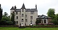 Gilmilnscroft House , Sorn, East Ayrshire.jpg 4,638 × 2,401; 1.82 MB
-
 Gilmilnscroft House, Sorn, East Ayrshire. North-east view.jpg 3,772 × 2,682; 1.78 MB
-
 Haggis Bank lane to Laigh Holehouse and Holehouse Mill. Sorn. East Ayrshire.jpg 4,896 × 2,752; 5.03 MB
-
 Haggis Bank lime kiln burning chamber, Sorn, East Ayrshire.jpg 4,896 × 2,752; 5.26 MB
-
 Haggis Bank lime kiln, Sorn, East Ayrshire.jpg 4,896 × 2,752; 5.19 MB
-
 Henryston - geograph.org.uk - 342540.jpg 640 × 427; 43 KB
-
 Henryston Woodland - geograph.org.uk - 337244.jpg 640 × 427; 130 KB
-
 Hillhead of Gilminscroft - geograph.org.uk - 342529.jpg 640 × 426; 84 KB
-
 Holehouse Mill ruins and raised area, Sorn, East Ayrshire.jpg 4,716 × 2,737; 4.92 MB
-
 Holehouse Mill ruins, Holehouse Holm, Sorn, East Ayrshire.jpg 4,865 × 2,194; 2.23 MB
-
 Holehouse Mill ruins. Gable end. Holehouse Holm, Sorn, East Ayrshire.jpg 4,896 × 2,752; 6.31 MB
-
 Holehouse Mill, old lade, Sorn, East Ayrshire.jpg 4,803 × 2,731; 4.67 MB
-
 Holehouse Mill, ruins of miller's house, Sorn, East Ayrshire.jpg 4,896 × 2,752; 4.53 MB
-
 Holehouse Miller's house ruins, Sorn, East Ayrshire.jpg 4,460 × 2,741; 4.65 MB
-
 Inosculation between an ash a hawthorn. Holehouse Holm, Sorn, East Ayrshire.jpg 3,148 × 2,752; 1.94 MB
-
 Knowhead Farm - geograph.org.uk - 342094.jpg 640 × 426; 48 KB
-
 Knowhead road junction - geograph.org.uk - 321982.jpg 640 × 426; 89 KB
-
 Laigh Holhouse site, beech tree plantings, Sorn, East Ayrshire.jpg 4,538 × 1,940; 1.78 MB
-
 Lime Kiln at Dalgain Lime Works, Holhouse Holm, Sorn, East Ayrshire, Scotland.jpg 3,834 × 2,750; 3.06 MB
-
 Lime kiln at Dalgain Lime Works, Holhouse Holm, Sorn, East Ayrshire.jpg 4,896 × 2,752; 2.89 MB
-
 Lime kiln. Haggis Bank, Sorn, East Ayrshire.jpg 2,659 × 2,737; 2.49 MB
-
 Local Authority Housing - geograph.org.uk - 337447.jpg 640 × 426; 62 KB
-
 Meadowhead - geograph.org.uk - 342079.jpg 640 × 426; 65 KB
-
 Meanders on the Cessnock Water - geograph.org.uk - 637521.jpg 640 × 480; 95 KB
-

-
 New Private Houses - geograph.org.uk - 337246.jpg 640 × 426; 72 KB
-
 Obsolete deer-proof fencing - geograph.org.uk - 637519.jpg 640 × 480; 121 KB
-
 Old bridge over the river Ayr at Sorn - geograph.org.uk - 106823.jpg 480 × 640; 90 KB
-
 Old Lime kiln at Dalgain Lime Works, Holhouse Holm, Sorn, East Ayrshire.jpg 4,056 × 2,208; 3.52 MB
-
 Old site of retting pond, Sorn, East Ayrshire.jpg 4,896 × 2,752; 6.32 MB
-
 Private House - geograph.org.uk - 342500.jpg 640 × 426; 57 KB
-
 Private Housing, Sorn - geograph.org.uk - 337427.jpg 640 × 426; 64 KB
-
 Resin exudate on Larix decidua bark. Dalgain Wood, Sor, East Ayrshire.jpg 1,714 × 2,567; 1.49 MB
-
 River Ayr - geograph.org.uk - 569749.jpg 450 × 600; 111 KB
-
 River Ayr at Holehouse Mill. Holehouse Holm, Sorn, East Ayrshire.jpg 4,896 × 2,752; 3.43 MB
-
 Road Junction - geograph.org.uk - 342184.jpg 640 × 426; 97 KB
-
 Ruin above the Cessnock Water - geograph.org.uk - 637947.jpg 640 × 480; 90 KB
-
 Ruins at Westown Burn, Sorn, East Ayrshire.jpg 4,896 × 2,752; 6.04 MB
-
 Ruins of Holehouse Mill, Holehouse Holm, Sorn, East Ayrshire.jpg 4,896 × 2,752; 4.81 MB
-
 Sorn Bridge and Cottage, East Ayrshire, Scotland.jpg 4,526 × 3,344; 5.6 MB
-
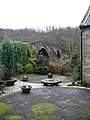
 Sorn bridge over the river Ayr - geograph.org.uk - 106820.jpg 640 × 480; 176 KB
-
 Sorn Church frontage, East Ayrshire, Scotland.jpg 4,083 × 3,221; 4.18 MB
-
 Sorn from the air (geograph 5613183).jpg 640 × 480; 148 KB
-
 Sorn Mains - geograph.org.uk - 335547.jpg 640 × 426; 67 KB
-
 Sorn old bridge.jpg 4,032 × 3,024; 6.86 MB
-
 Sorn Woods, East Ayrshire, Scotland.jpg 4,896 × 2,752; 4.15 MB
-
 Sorn's Jougs, Sorn Church, East Ayrshire, Scotland.jpg 4,608 × 3,456; 3.65 MB
-
 Sorn,Conservation Village - geograph.org.uk - 344081.jpg 640 × 426; 80 KB
-
 Telecommunication Mast - geograph.org.uk - 342516.jpg 426 × 640; 47 KB
-
 The Haggis Bank lime kiln, Sorn, East Ayrshire.jpg 4,896 × 2,752; 4.46 MB
-
 The Laigh Holhouse site, beech tree plantings, Sorn, East Ayrshire.jpg 4,122 × 1,905; 1.64 MB
-
 The old Haggis Bank lime kiln, Sorn, East Ayrshire.jpg 1,901 × 1,388; 1.24 MB
-
 The old Holehouse Mill and miller's house ruins, Sorn, East Ayrshire.jpg 4,866 × 2,310; 2.6 MB
-
 The River Ayr - geograph.org.uk - 573925.jpg 440 × 600; 78 KB
-
 The Sorn Inn - geograph.org.uk - 106822.jpg 640 × 515; 62 KB
-
 Viburnum opulus (Guelder Rose) berries, Sorn, East Ayrshire.jpg 3,577 × 2,670; 1.5 MB
-
 Viburnum opulus berries, Sorn, East Ayrshire.jpg 2,991 × 2,129; 1.18 MB
-
 Westown Burn, Sorn, East Ayrshire.jpg 4,896 × 2,752; 6.42 MB


.jpg)


_berries,_Sorn,_East_Ayrshire.jpg)

