Category:South Stoke, Oxfordshire
Jump to navigation
Jump to search
English: South Stoke is a village and civil parish on the River Thames, about north of Goring-on-Thames in South Oxfordshire.
village and civil parish in South Oxfordshire district, South Oxfordshire, England  | |||||
| Upload media | |||||
| Instance of | |||||
|---|---|---|---|---|---|
| Location | South Oxfordshire, Oxfordshire, South East England, England | ||||
| Located in or next to body of water | |||||
| Population |
| ||||
| Area |
| ||||
| official website | |||||
 | |||||
Subcategories
This category has the following 2 subcategories, out of 2 total.
C
- Cleeve Lock, River Thames (8 F)
S
Media in category "South Stoke, Oxfordshire"
The following 200 files are in this category, out of 412 total.
(previous page) (next page)-
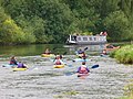
 A cold mornings row - geograph.org.uk - 3312030.jpg 1,024 × 683; 183 KB
-

-
 A new house in South Stoke - geograph.org.uk - 3920795.jpg 640 × 430; 68 KB
-
 A pair of eights - geograph.org.uk - 3298710.jpg 1,024 × 683; 150 KB
-
 A parting look - geograph.org.uk - 3298723.jpg 1,024 × 683; 244 KB
-
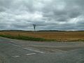
 A train by a field - geograph.org.uk - 3026444.jpg 1,500 × 1,000; 184 KB
-
 A Type 22 - geograph.org.uk - 3298613.jpg 1,024 × 683; 261 KB
-
 A wider view - geograph.org.uk - 3297517.jpg 1,024 × 683; 139 KB
-
 Across the fields - geograph.org.uk - 51465.jpg 640 × 481; 46 KB
-
 After the pipe was laid - geograph.org.uk - 1313031.jpg 640 × 426; 103 KB
-
 Alcove near the Lancet - geograph.org.uk - 4898056.jpg 533 × 800; 65 KB
-
 All fallen down - geograph.org.uk - 1345377.jpg 640 × 480; 125 KB
-
 Along the North Side - geograph.org.uk - 4902593.jpg 1,024 × 683; 220 KB
-
 Along the side - geograph.org.uk - 3298612.jpg 533 × 800; 207 KB
-
 Angel in the Churchyard - geograph.org.uk - 4902319.jpg 533 × 800; 118 KB
-
 Another guess - geograph.org.uk - 2703735.jpg 1,024 × 768; 280 KB
-
 Approaching Little Stoke on the B4009 - geograph.org.uk - 2568051.jpg 3,636 × 2,375; 1.13 MB
-
 Approaching South Stoke on the Ridgeway - geograph.org.uk - 4442773.jpg 2,592 × 1,944; 1.72 MB
-
 Arable land - geograph.org.uk - 6241182.jpg 3,264 × 2,448; 1.82 MB
-
 Ash Cottage, Wallingford Road - geograph.org.uk - 4026402.jpg 1,024 × 683; 193 KB
-
 Ash Cottages, Littlestoke - geograph.org.uk - 2822821.jpg 1,600 × 1,067; 391 KB
-
 At the Crossroads - geograph.org.uk - 2079291.jpg 3,496 × 2,660; 2.45 MB
-
 Awaiting the lines - geograph.org.uk - 4887648.jpg 1,024 × 768; 125 KB
-
 B4009 crossroads in South Stoke - geograph.org.uk - 2568139.jpg 3,648 × 2,267; 1.45 MB
-
 Back of the pillar - geograph.org.uk - 2703731.jpg 600 × 800; 143 KB
-
 Back to South Stoke - geograph.org.uk - 1323721.jpg 400 × 600; 63 KB
-

-
 Benchmark on culvert, Ferry Lane, South Stoke - geograph.org.uk - 4104252.jpg 683 × 1,024; 251 KB
-
 Benchmark on Ivol Barn outbuilding - geograph.org.uk - 4103234.jpg 683 × 1,024; 387 KB
-
 Benchmark on Moulsford Viaduct - geograph.org.uk - 4104312.jpg 599 × 1,024; 173 KB
-
 Benchmark on outbuilding of The Corner House - geograph.org.uk - 4104125.jpg 683 × 1,024; 341 KB
-
 Benchmark on railway bridge, South Bank - geograph.org.uk - 4103522.jpg 683 × 1,024; 242 KB
-
 Benchmark on the base - geograph.org.uk - 2703743.jpg 600 × 800; 172 KB
-
 Benchmark on The Old Post Office, The Street - geograph.org.uk - 4104075.jpg 683 × 1,024; 226 KB
-
 Benchmark on ^2 Ash Cottage - geograph.org.uk - 4026370.jpg 683 × 1,024; 234 KB
-
 Benchmark on ^4 Freedom Cottages - geograph.org.uk - 4103212.jpg 664 × 1,024; 212 KB
-
 Benchmark on ^4 Oak Cottages - geograph.org.uk - 4025104.jpg 640 × 1,024; 258 KB
-
 Benchmarks on Moulsford Viaduct - geograph.org.uk - 4104356.jpg 683 × 1,024; 216 KB
-
 Bending up the hill - geograph.org.uk - 1168338.jpg 640 × 426; 59 KB
-
 Bequest on the memorial - geograph.org.uk - 4894585.jpg 1,024 × 683; 165 KB
-
 Between the bridges - geograph.org.uk - 2041674.jpg 600 × 800; 137 KB
-
 Bible on the Stand - geograph.org.uk - 4897843.jpg 1,024 × 683; 109 KB
-
 Boat on the river - geograph.org.uk - 1314527.jpg 640 × 426; 66 KB
-
 Brick pillars to the field - geograph.org.uk - 1168318.jpg 640 × 426; 77 KB
-
 Bridleway to White hill - geograph.org.uk - 1168428.jpg 400 × 600; 43 KB
-
 Broken Gates on Swans Way - geograph.org.uk - 2612305.jpg 3,648 × 2,736; 2.22 MB
-
 Buried benchmark on Ferry Road railway bridge - geograph.org.uk - 4104183.jpg 675 × 1,024; 200 KB
-
 By Runsford Hole - geograph.org.uk - 915046.jpg 640 × 480; 108 KB
-
 Canoe on River Thames - geograph.org.uk - 5402778.jpg 3,456 × 4,608; 4.28 MB
-
 Chalk Pit - geograph.org.uk - 2704792.jpg 1,024 × 768; 215 KB
-
 Chalky soil, South Stoke, Oxfordshire - geograph.org.uk - 4818050.jpg 3,172 × 2,165; 1.37 MB
-
 Chandelier in the Aisle - geograph.org.uk - 4893237.jpg 533 × 800; 88 KB
-
 Churchyard looking East - geograph.org.uk - 4898710.jpg 1,024 × 683; 210 KB
-
 Cleeve Weir - geograph.org.uk - 950580.jpg 640 × 480; 100 KB
-
 Coming along the river - geograph.org.uk - 3508219.jpg 1,024 × 683; 137 KB
-
 Corner of the Churchyard - geograph.org.uk - 4898910.jpg 1,024 × 683; 244 KB
-
 Cottage in South Stoke - geograph.org.uk - 3948959.jpg 640 × 430; 51 KB
-
 Cottage on the street - geograph.org.uk - 1324982.jpg 640 × 426; 70 KB
-
 Cottages at The Oak - geograph.org.uk - 4025129.jpg 1,024 × 740; 154 KB
-
 Covered reservoir - geograph.org.uk - 2704796.jpg 1,024 × 768; 343 KB
-
 Cross Keys Road, South Stoke - geograph.org.uk - 3387471.jpg 3,648 × 2,736; 3.02 MB
-
 Crosses by the Base - geograph.org.uk - 4897695.jpg 1,024 × 683; 136 KB
-
 Daffodils near the Stump - geograph.org.uk - 4898906.jpg 1,024 × 683; 265 KB
-
 Dark skies - geograph.org.uk - 4902762.jpg 1,024 × 683; 115 KB
-
 David and his Trainer - geograph.org.uk - 2601413.jpg 1,024 × 683; 217 KB
-
 David Gordon Dill - geograph.org.uk - 4897693.jpg 1,024 × 683; 135 KB
-
 Down to the river - geograph.org.uk - 1345319.jpg 400 × 600; 301 KB
-
 Eight on the river - geograph.org.uk - 3312032.jpg 1,024 × 683; 190 KB
-
 Elizabeth Barber Memorial - geograph.org.uk - 4895025.jpg 533 × 800; 87 KB
-
 Embankment on the riverside - geograph.org.uk - 765185.jpg 640 × 427; 44 KB
-
 Embankment, Wallingford Rd - geograph.org.uk - 5646538.jpg 640 × 351; 29 KB
-
 Emma Weston - geograph.org.uk - 4898904.jpg 1,024 × 683; 208 KB
-
 End of the lane - geograph.org.uk - 3311885.jpg 1,024 × 683; 225 KB
-
 End of the slipway - geograph.org.uk - 1343837.jpg 450 × 600; 101 KB
-
 End of the Street - geograph.org.uk - 1325078.jpg 640 × 426; 64 KB
-
 Faded Benchmark - geograph.org.uk - 4902587.jpg 533 × 800; 156 KB
-
 Faded Writing - geograph.org.uk - 4892926.jpg 1,024 × 683; 107 KB
-
 Fairmile through the trees - geograph.org.uk - 3297514.jpg 1,024 × 683; 169 KB
-
 Farm track, South Stoke - geograph.org.uk - 790217.jpg 640 × 480; 135 KB
-
 Farm track, South Stoke - geograph.org.uk - 790219.jpg 640 × 480; 130 KB
-
 Farmland - geograph.org.uk - 37066.jpg 640 × 481; 230 KB
-
 Farmland - geograph.org.uk - 37067.jpg 640 × 481; 200 KB
-
 Farmland and houses, South Stoke - geograph.org.uk - 2680046.jpg 640 × 480; 110 KB
-
 Farmland near South Stoke - geograph.org.uk - 3948955.jpg 640 × 430; 41 KB
-
 Farmland near South Stoke - geograph.org.uk - 4701760.jpg 800 × 334; 49 KB
-
 Farmland on the edge of South Stoke - geograph.org.uk - 3920827.jpg 640 × 430; 71 KB
-
 Farmland on the floodplain - geograph.org.uk - 5367394.jpg 640 × 426; 44 KB
-
 Farmland, Ipsden, Oxfordshire - geograph.org.uk - 4858883.jpg 4,421 × 2,603; 4.87 MB
-
 Farmland, Littlestoke - geograph.org.uk - 1556137.jpg 640 × 480; 101 KB
-
 Farmland, South Stoke - geograph.org.uk - 1058238.jpg 640 × 427; 78 KB
-
 Farmland, South Stoke - geograph.org.uk - 1058610.jpg 640 × 480; 128 KB
-
 Farmland, South Stoke - geograph.org.uk - 6188016.jpg 1,024 × 683; 172 KB
-
 Farmland, South Stoke - geograph.org.uk - 682400.jpg 640 × 480; 158 KB
-
 Farmland, South Stoke - geograph.org.uk - 688223.jpg 640 × 480; 135 KB
-
 Farmland, South Stoke - geograph.org.uk - 790211.jpg 640 × 480; 143 KB
-
 Farmland, South Stoke - geograph.org.uk - 790214.jpg 640 × 480; 137 KB
-
 Farmland, South Stoke - geograph.org.uk - 790215.jpg 640 × 480; 192 KB
-
 Farmland, South Stoke, Oxfordshire - geograph.org.uk - 4821221.jpg 5,485 × 3,560; 2 MB
-
 Farmland, South Stoke, Oxfordshire - geograph.org.uk - 4821613.jpg 640 × 426; 52 KB
-
 Farmland, South Stoke, Oxfordshire - geograph.org.uk - 4857695.jpg 3,394 × 3,527; 5.6 MB
-
 Farmland, South Stoke, Oxfordshire - geograph.org.uk - 4864502.jpg 5,826 × 3,241; 6.03 MB
-
 Farmland, Woodcote, Oxfordshire - geograph.org.uk - 4843754.jpg 3,663 × 1,763; 3.9 MB
-
 Ferry road - geograph.org.uk - 1325104.jpg 400 × 600; 52 KB
-
 Field at South Stoke - geograph.org.uk - 6036854.jpg 4,109 × 1,977; 710 KB
-
 Field near South Stoke - geograph.org.uk - 3948962.jpg 640 × 430; 56 KB
-
 Fields by Wallingford Road, South Stoke - geograph.org.uk - 5974310.jpg 1,920 × 1,280; 1.11 MB
-

-
 Fifty MPH - geograph.org.uk - 2828811.jpg 3,648 × 2,736; 2.06 MB
-
 Filming the row - geograph.org.uk - 3312034.jpg 1,024 × 683; 185 KB
-

-
 Flags on Watch Folly - geograph.org.uk - 2703746.jpg 1,024 × 768; 104 KB
-
 Flooding by the River Thames - geograph.org.uk - 3948950.jpg 640 × 351; 43 KB
-
 Floodplain - geograph.org.uk - 5367376.jpg 640 × 426; 44 KB
-
 Floodplain of the River Thames - geograph.org.uk - 3920830.jpg 640 × 430; 65 KB
-
 Floodplain of the River Thames - geograph.org.uk - 5646535.jpg 640 × 426; 35 KB
-
 Font at St Andrews - geograph.org.uk - 4892948.jpg 533 × 800; 84 KB
-

-
 Footpath, South Stoke, Oxfordshire - geograph.org.uk - 4860635.jpg 800 × 559; 161 KB
-
 Fox Memorials - geograph.org.uk - 4897847.jpg 1,024 × 683; 77 KB
-
 Freedom Cottages - geograph.org.uk - 3450966.jpg 640 × 425; 215 KB
-
 Freedom Cottages - geograph.org.uk - 3450969.jpg 640 × 428; 225 KB
-
 Freedom Cottages - geograph.org.uk - 4103226.jpg 1,024 × 683; 206 KB
-
 Freedom Cottages - geograph.org.uk - 5367401.jpg 640 × 426; 37 KB
-
 Freightliner train heads south at South Stoke - geograph.org.uk - 4104390.jpg 1,024 × 683; 174 KB
-
 From the North East - geograph.org.uk - 4902577.jpg 1,024 × 683; 159 KB
-
 Further along the street - geograph.org.uk - 1323597.jpg 640 × 426; 64 KB
-
 Gantries out of South Stoke - geograph.org.uk - 4887679.jpg 1,024 × 768; 122 KB
-
 Gate on the back - geograph.org.uk - 3298611.jpg 1,024 × 683; 274 KB
-
 Gate on The Ridgeway National Trail - geograph.org.uk - 5402784.jpg 3,456 × 4,608; 5.58 MB
-
 Gateposts beside A4009 at Swan's Way junction - geograph.org.uk - 4103181.jpg 1,024 × 683; 133 KB
-
 Geese in the meadow - geograph.org.uk - 1314639.jpg 640 × 426; 79 KB
-
 Genesis offices and Glebe Farm, Icknield Road - geograph.org.uk - 5257770.jpg 1,024 × 683; 179 KB
-
 Giving a wave - geograph.org.uk - 2601408.jpg 1,024 × 683; 132 KB
-
 Good afternoon - geograph.org.uk - 3450962.jpg 640 × 439; 232 KB
-
 Goring & Streatley South Wales express geograph-2913944-by-Ben-Brooksbank.jpg 2,325 × 1,298; 1.36 MB
-
 Goring & Streatley SR locomotive geograph-2970075-by-Ben-Brooksbank.jpg 1,800 × 1,152; 1.27 MB
-
 Graves near the Lychgate - geograph.org.uk - 4902755.jpg 1,024 × 683; 216 KB
-
 Great Western Electrification - geograph.org.uk - 4790390.jpg 640 × 426; 86 KB
-
 Griffith Higgs - geograph.org.uk - 4894572.jpg 533 × 800; 100 KB
-
 Griffith Higgs Memorial - geograph.org.uk - 4894571.jpg 533 × 800; 88 KB
-
 Gurner Memorial - geograph.org.uk - 4897845.jpg 1,024 × 683; 120 KB
-
 Gyrocopters at Chiltern Park Airfield - geograph.org.uk - 5169703.jpg 3,481 × 2,364; 2.1 MB
-
 Hannes memorial - geograph.org.uk - 4894890.jpg 533 × 800; 93 KB
-
 Harward Memorial - geograph.org.uk - 4894883.jpg 533 × 800; 85 KB
-
 Having a drink - geograph.org.uk - 1314665.jpg 640 × 459; 87 KB
-
 Heading down the river. - geograph.org.uk - 1313047.jpg 640 × 426; 77 KB
-
 Heading up to the Wallingford Road - geograph.org.uk - 1278009.jpg 640 × 480; 75 KB
-
 Headstone near the Path - geograph.org.uk - 4902749.jpg 533 × 800; 151 KB
-
 Headstones at the Front - geograph.org.uk - 4902567.jpg 1,024 × 683; 162 KB
-
 Headstones near the Tomb - geograph.org.uk - 4902337.jpg 1,024 × 683; 263 KB
-
 Here he comes - geograph.org.uk - 2601400.jpg 1,024 × 683; 245 KB
-
 Higgs Memorial - geograph.org.uk - 4894879.jpg 533 × 800; 77 KB
-
 House over the river - geograph.org.uk - 1315565.jpg 640 × 426; 51 KB
-
 Houses at South Stoke - geograph.org.uk - 6241176.jpg 2,875 × 2,133; 1.51 MB
-
 Houses on South Bank - geograph.org.uk - 1323664.jpg 640 × 426; 52 KB
-
 Icknield Farm, Icknield Road - geograph.org.uk - 4024123.jpg 1,024 × 683; 195 KB
-
 Icknield Road - geograph.org.uk - 2158203.jpg 640 × 480; 70 KB
-
 Icknield Road - geograph.org.uk - 3450944.jpg 640 × 427; 202 KB
-
 Information on Griffith Higgs - geograph.org.uk - 4894582.jpg 1,024 × 683; 133 KB
-
 Information on the tree - geograph.org.uk - 1345340.jpg 400 × 600; 204 KB
-
 Inside a Type 22 - geograph.org.uk - 3298708.jpg 1,024 × 683; 135 KB
-
 Inside the Chancel Arch - geograph.org.uk - 4898714.jpg 533 × 800; 96 KB
-
 Ivol Barn - geograph.org.uk - 1278091.jpg 640 × 480; 68 KB
-
 Ivol Barn - geograph.org.uk - 3450948.jpg 640 × 424; 196 KB
-
 Ivol Barn - geograph.org.uk - 3450956.jpg 640 × 427; 221 KB
-
 Ivol Barns - geograph.org.uk - 2096877.jpg 3,648 × 2,736; 3.59 MB
-

-
 Kaffirs - geograph.org.uk - 2826259.jpg 3,648 × 2,517; 1.61 MB
-
 Lane across the river - geograph.org.uk - 3311892.jpg 1,024 × 683; 237 KB
-
 Lichen on the Headstone - geograph.org.uk - 4902339.jpg 533 × 800; 144 KB
-
 Lichen on the top - geograph.org.uk - 1168320.jpg 640 × 426; 79 KB
-
 Line of Kneelers - geograph.org.uk - 4898702.jpg 533 × 800; 107 KB
-
 Little Stoke.jpg 2,592 × 1,944; 1.7 MB
-
 Littlestoke crossroad - geograph.org.uk - 2704742.jpg 1,024 × 768; 97 KB
-
 Littlestoke House - geograph.org.uk - 3077800.jpg 3,372 × 2,508; 900 KB
-
 Littlestoke Manor Farm - geograph.org.uk - 3035774.jpg 1,500 × 1,000; 196 KB
-
 Localised flooding - geograph.org.uk - 3948953.jpg 640 × 430; 44 KB
-
 Looking at the centre - geograph.org.uk - 2703724.jpg 600 × 800; 168 KB
-
 Looking down the street - geograph.org.uk - 1324999.jpg 640 × 426; 55 KB
-
 Looking in the quarry - geograph.org.uk - 2702586.jpg 1,024 × 768; 301 KB
-
 Looking to the North Side - geograph.org.uk - 4898912.jpg 1,024 × 683; 236 KB
-
 Looking towards the Oak - geograph.org.uk - 2704739.jpg 1,024 × 768; 129 KB
-
 Looking West - geograph.org.uk - 4898915.jpg 1,024 × 683; 192 KB
-
 Lost behind the trees - geograph.org.uk - 3508226.jpg 1,024 × 683; 119 KB
-
 Lough Down direction - geograph.org.uk - 2703739.jpg 1,024 × 768; 250 KB
-
 Lower Cadley's Farm - geograph.org.uk - 3450937.jpg 640 × 427; 203 KB
-
 Lower Cadley's Farm - geograph.org.uk - 3450947.jpg 640 × 453; 263 KB
-
 Lower Cadley's Farm - geograph.org.uk - 51468.jpg 640 × 481; 47 KB
-
 Lower Cadley's Farm and Ivol Barn - geograph.org.uk - 3450934.jpg 640 × 430; 157 KB
-

-

-

-
 Manure heap off Icknield Way - geograph.org.uk - 3450929.jpg 640 × 427; 215 KB
-
 Marshall Memorial - geograph.org.uk - 4897701.jpg 533 × 800; 62 KB
-
 Meadow by Ferry Lane - geograph.org.uk - 3298720.jpg 1,024 × 683; 120 KB
-
 Meeting Area - geograph.org.uk - 4898706.jpg 1,024 × 683; 130 KB
-
 Memorial by the Alcove - geograph.org.uk - 4897691.jpg 533 × 800; 72 KB
-
 Memorial in the Corner - geograph.org.uk - 4892935.jpg 1,024 × 683; 97 KB
-
 Middle Barn - geograph.org.uk - 2612282.jpg 3,648 × 2,736; 1.94 MB
-
 Middle Barn - geograph.org.uk - 4023808.jpg 1,024 × 683; 237 KB


