Category:Sowjetischer Ehrenfriedhof Gräbendorf
Jump to navigation
Jump to search
| Object location | | View all coordinates using: OpenStreetMap |
|---|
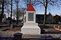
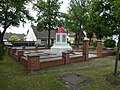
English: Pictures of the memorial for the fallen Soviet soldiers in World War II in Gräbendorf , Heidesee municipality , Dahme-Spreewald district, Brandenburg state, Germany.
Deutsch: Ansichten des Gefallenendenkmals für die im Zweiten Weltkrieg gefallenen Sowjetsoldaten in Gräbendorf , Gemeinde Heidesee , Landkreis Dahme-Spreewald , Land Brandenburg, Deutschland.
Français : Photos du monument aux morts de l'armée sovietique pendant la Seconde Guerre Mondiale à Gräbendorf , commune de Heidesee , arrondissement de Dahme-Spreewald , état fédéral de Brandebourg, Allemagne
Español: Vistas del monumento a los caidos del ejército sovietico durante la Segunda Guerra Mundial en Gräbendorf , municipio de Heidesee , distrito de Dahme-Spreewald , estado federado de Brandeburgo, Alemania
Address:
Dorfanger 7, Gräbendorf, 15754 Heidesee Original file name
This is the category of the Brandenburger Baudenkmal (cultural heritage monument) with the ID 09140108 (Wikidata)
|
| Upload media | |||||
| Instance of | |||||
|---|---|---|---|---|---|
| Location | Heidesee, Dahme-Spreewald District, Brandenburg, Germany | ||||
| Heritage designation | |||||
 | |||||
Media in category "Sowjetischer Ehrenfriedhof Gräbendorf"
The following 12 files are in this category, out of 12 total.
-
 Sowjetisches Gefallenendenkmal Gräbendorf 2019 E.jpg 4,864 × 3,648; 7.07 MB
-
 Gräbendorf Sowjetischer Ehrenfriedhof linke Seite.jpg 4,032 × 3,024; 4.82 MB
-
 Gräbendorf Sowjetischer Ehrenfriedhof rechte Seite.jpg 4,032 × 3,024; 4.99 MB
-
 Gräbendorf Sowjetischer Ehrenfriedhof Rückseite.jpg 4,032 × 3,024; 3.84 MB
-
 Gräbendorf Sowjetischer Ehrenfriedhof Vorderseite.jpg 4,032 × 3,024; 4.39 MB
-
 Heidesee Gräbendorf sowejtisches Ehrendenkmal.jpg 3,872 × 2,592; 1.81 MB
-
 Sowjetischer Ehrenfriedhof Gräbendorf 2019-05-26 -1.jpg 4,896 × 3,672; 7.25 MB
-
 Sowjetischer Ehrenfriedhof Gräbendorf 2019-05-26 -2.jpg 4,896 × 3,672; 7.15 MB
-
 Sowjetischer Ehrenfriedhof Gräbendorf 2019-05-26 -3.jpg 4,896 × 3,672; 6.56 MB
-
 Sowjetischer Ehrenfriedhof Gräbendorf 2019-05-26 -4.jpg 4,896 × 3,672; 6.84 MB
-
 Sowjetischer Ehrenfriedhof Gräbendorf 2019-05-26 -5.jpg 4,896 × 3,672; 7.06 MB
-
 Sowjetischer Ehrenfriedhof Gräbendorf 2019-05-26 -6.jpg 4,896 × 3,672; 7.02 MB


