Category:Spital in the Street
Jump to navigation
Jump to search
human settlement in United Kingdom  | |||||
| Upload media | |||||
| Instance of | |||||
|---|---|---|---|---|---|
| Location | Glentham, West Lindsey, Lincolnshire, East Midlands, England | ||||
 | |||||
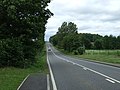
English: Spital in the Street is a small hamlet in Lincolnshire, England. It is on the Roman Ermine Street (hence the suffix), which forms the modern A15 road, near its junction with the A631 road, known as Caenby Corner, north of Lincoln. The first part of its name, "Spital", comes from the ancient hospital for the poor which was situated there, this had its origins in a Hermitage.
Media in category "Spital in the Street"
The following 11 files are in this category, out of 11 total.
-
 A15 at Spital in the Street - geograph.org.uk - 3791577.jpg 2,840 × 1,862; 2.62 MB
-
-
 Arriving at Spital in the Street - geograph.org.uk - 2495368.jpg 1,024 × 768; 136 KB
-
 Cromwell House and former Inn Spital in the Street - geograph.org.uk - 4472770.jpg 5,184 × 3,456; 7.44 MB
-
 Home Farm, Spital in the Street - geograph.org.uk - 2625439.jpg 640 × 417; 129 KB
-
 Home Farm, Spital in the Street - geograph.org.uk - 2987777.jpg 640 × 480; 87 KB
-
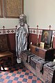
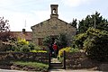 The Chapel of St Edmund Spital in the Street - geograph.org.uk - 4472602.jpg 5,045 × 3,363; 6.09 MB
-
 The Chapel of St Edmund Spital in the Street - geograph.org.uk - 4478885.jpg 3,456 × 5,184; 6.57 MB
-
 The Chapel of St Edmund Spital in the Street - geograph.org.uk - 4478895.jpg 5,184 × 3,456; 6.32 MB
-
 The Chapel of St Edmund Spital in the Street - geograph.org.uk - 4478897.jpg 5,122 × 3,414; 4.87 MB
-
 The Ostrich and Cromwell House - geograph.org.uk - 124325.jpg 640 × 427; 112 KB


