Category:Spitalstraße 7, Scheune (Höchstadt an der Aisch)
Jump to navigation
Jump to search
| Object location | | View all coordinates using: OpenStreetMap |
|---|
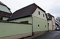
This is the category of the Bavarian Baudenkmal (cultural heritage monument) with the ID D-5-72-135-70 (Wikidata)
|
Deutsch: Höchstadt an der Aisch - Spitalstraße 7 - Scheune. Zugehörig, mit Halbwalmdach.
Media in category "Spitalstraße 7, Scheune (Höchstadt an der Aisch)"
This category contains only the following file.
-
 Höchstadt an der Aisch, Spitalstraße 7, 003.jpg 4,928 × 3,264; 7.57 MB
