Category:Sprengenberg, Haarle
Jump to navigation
Jump to search
| Object location | | View all coordinates using: OpenStreetMap |
|---|
| Object location | | View all coordinates using: OpenStreetMap |
|---|
| Object location | | View all coordinates using: OpenStreetMap |
|---|
villa in Hellendoorn, Netherlands  | |||||
| Upload media | |||||
| Instance of | |||||
|---|---|---|---|---|---|
| Part of |
| ||||
| Location | Haarle, Hellendoorn, Hellendoorn, Overijssel, Netherlands | ||||
| Street address |
| ||||
| Located on street |
| ||||
| Architect | |||||
| Heritage designation |
| ||||
 | |||||
|
This is a category about rijksmonument number 21407
|
| Address |
|
|
This is a category about rijksmonument number 512241
|
| Address |
|
|
This is a category about rijksmonument number 512242
|
| Address |
|
Media in category "Sprengenberg, Haarle"
The following 5 files are in this category, out of 5 total.
-

-

-
 Sprengenberg Haarle 2008.jpg 2,816 × 2,112; 1.71 MB
-
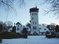 Sprengenberg in de Sneeuw 16-12-2005.jpg 1,600 × 1,200; 361 KB
-
 Sprengenberg Palthevilla badhuis.jpg 3,072 × 2,304; 2.58 MB


