Category:St Cathen's Church, Llangathen
Jump to navigation
Jump to search
| Object location | | View all coordinates using: OpenStreetMap |
|---|
church in Llangathen, Carmarthenshire, Wales  | |||||
| Upload media | |||||
| Instance of | |||||
|---|---|---|---|---|---|
| Named after |
| ||||
| Dedicated to |
| ||||
| Location | Llangathen, Carmarthenshire, Wales | ||||
| Heritage designation | |||||
| Inception |
| ||||
| Elevation above sea level |
| ||||
| Religion or worldview | |||||
 | |||||
Media in category "St Cathen's Church, Llangathen"
The following 22 files are in this category, out of 22 total.
-
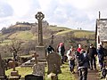
 Bedd Mary Evans' Grave - geograph.org.uk - 2199131.jpg 690 × 517; 114 KB
-
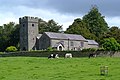
 Church of St Cathen (geograph 6862950).jpg 2,048 × 1,536; 1.4 MB
-
 Church of St Cathen, Llangathen, Carmarthenshire.jpg 4,256 × 2,848; 6.25 MB
-
 Eglwys Llangathen Church - geograph.org.uk - 3840961.jpg 640 × 466; 62 KB
-
 Eglwys Llangathen Church - geograph.org.uk - 4086259.jpg 640 × 480; 82 KB
-
 Llangathen Church - geograph.org.uk - 143422.jpg 640 × 178; 86 KB
-
 Llangathen Church interior.jpg 2,448 × 3,264; 1.11 MB
-
 Llangathen Church porch, Great War Memorial, and Grongaer Hill in the distance.jpg 4,256 × 2,848; 5.8 MB
-
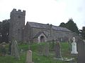 Parish church, Llangathen - geograph.org.uk - 1444247.jpg 640 × 480; 51 KB
-
 Parish Church, Llangathen - geograph.org.uk - 1444251.jpg 640 × 480; 50 KB
-
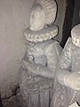
 Tomb of Bishop Anthony Rudd, St Cathen's Church, Llangathen, Carmarthenshire, Wales 01.jpg 3,264 × 2,448; 1.55 MB
-
 Tomb of Bishop John Rudd and Mrs Rudd, Llangathen Church 02.jpg 2,448 × 3,264; 2.16 MB
-
 Tomb of Bishop John Rudd and Mrs Rudd, Llangathen Church 03.jpg 2,448 × 3,264; 1.88 MB
-
 Tomb of Bishop John Rudd and Mrs Rudd, Llangathen Church 04.jpg 2,448 × 3,264; 1.86 MB
-
 Tomb of Bishop John Rudd and Mrs Rudd, Llangathen Church 05.jpg 3,264 × 2,448; 1.52 MB
-
 Tomb of Bishop John Rudd and Mrs Rudd, Llangathen Church 06.jpg 2,448 × 3,264; 1.5 MB
-
 Tomb of Bishop John Rudd and Mrs Rudd, Llangathen Church 07.jpg 2,448 × 3,264; 1.54 MB
-
 Tomb of Bishop John Rudd and Mrs Rudd, Llangathen Church 08.jpg 3,264 × 2,448; 1.03 MB
-
 Tomb of Bishop John Rudd and Mrs Rudd, Llangathen Church 09.jpg 2,448 × 3,264; 1.1 MB
-
 Tomb of Bishop John Rudd and Mrs Rudd, Llangathen Church 10.jpg 3,264 × 2,448; 1.41 MB
-
 Tomb of Bishop John Rudd and Mrs Rudd, Llangathen Church 11.jpg 2,448 × 3,264; 2.08 MB
-
 Tomb of Bishop John Rudd and Mrs Rudd, Llangathen Church 12.jpg 2,448 × 3,264; 1.61 MB

.jpg)


