Category:St George's Church, Cullercoats
Jump to navigation
Jump to search
| Object location | | View all coordinates using: OpenStreetMap |
|---|
church in North Tyneside, Tyne and Wear, England, UK"  | |||||
| Upload media | |||||
| Instance of | |||||
|---|---|---|---|---|---|
| Dedicated to | |||||
| Location | North Tyneside, Tyne and Wear, North East England, England | ||||
| Diocese | |||||
| Heritage designation |
| ||||
| Religion or worldview | |||||
| official website | |||||
 | |||||
| Address |
|
Media in category "St George's Church, Cullercoats"
The following 18 files are in this category, out of 18 total.
-
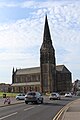
 Cullercoats, St George's Church - geograph.org.uk - 224166.jpg 370 × 432; 16 KB
-
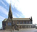
 St George's Church, Cullercoates - geograph.org.uk - 1635299.jpg 480 × 640; 71 KB
-

-
 The Links, Grand Parade, Tynemouth - geograph.org.uk - 1635343.jpg 5,559 × 2,387; 1.83 MB
-
 Église St George Cullercoats North Tyneside 1.jpg 5,184 × 3,456; 4.98 MB
-
 Église St George Cullercoats North Tyneside 10.jpg 3,456 × 5,184; 6.58 MB
-
 Église St George Cullercoats North Tyneside 11.jpg 3,456 × 5,184; 6.22 MB
-
 Église St George Cullercoats North Tyneside 12.jpg 4,829 × 4,098; 18.89 MB
-
 Église St George Cullercoats North Tyneside 13.jpg 3,456 × 5,184; 5.68 MB
-
 Église St George Cullercoats North Tyneside 14.jpg 4,866 × 6,308; 16.63 MB
-
 Église St George Cullercoats North Tyneside 2.jpg 3,456 × 5,184; 5.04 MB
-
 Église St George Cullercoats North Tyneside 3.jpg 3,456 × 5,184; 5.3 MB
-
 Église St George Cullercoats North Tyneside 4.jpg 7,086 × 6,239; 29.44 MB
-
 Église St George Cullercoats North Tyneside 5.jpg 3,456 × 5,184; 5.99 MB
-
 Église St George Cullercoats North Tyneside 6.jpg 5,320 × 4,286; 20.91 MB
-
 Église St George Cullercoats North Tyneside 7.jpg 3,456 × 5,184; 6.73 MB
-
 Église St George Cullercoats North Tyneside 8.jpg 3,456 × 5,184; 6.94 MB
-
 Église St George Cullercoats North Tyneside 9.jpg 3,456 × 5,184; 8.06 MB


Categories:
- 1880s Gothic Revival churches in England
- 19th-century churches in Tyne and Wear
- Anglican churches in Tyne and Wear
- Buildings by John Loughborough Pearson
- Churches in England built in 1884
- Churches in the Diocese of Newcastle
- Buildings in Cullercoats
- Gothic Revival churches in Tyne and Wear
- Grade I listed churches in Tyne and Wear
- Saint George churches in Tyne and Wear
- Churches in the Metropolitan Borough of North Tyneside
- Architectural basilicas in Tyne and Wear