Category:St Tetha's church, St Teath
Jump to navigation
Jump to search
| Object location | | View all coordinates using: OpenStreetMap |
|---|
church in Cornwall, UK  | |||||
| Upload media | |||||
| Instance of | |||||
|---|---|---|---|---|---|
| Dedicated to | |||||
| Location | St Teath, Cornwall, South West England, England | ||||
| Diocese | |||||
| Heritage designation |
| ||||
| Inception |
| ||||
| Religion or worldview | |||||
 | |||||
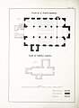
This is a category about listed building number 1327712. |
Media in category "St Tetha's church, St Teath"
The following 8 files are in this category, out of 8 total.
-
-
 Interior of St Tetha's church - geograph.org.uk - 689697.jpg 640 × 480; 113 KB
-
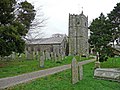 Parish church of St. Tetha, St Teath - geograph.org.uk - 681562.jpg 640 × 480; 125 KB
-
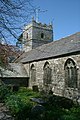
 St Teath Church - geograph.org.uk - 1629367.jpg 640 × 388; 67 KB
-
 St Teath Church - geograph.org.uk - 2825295.jpg 680 × 1,024; 204 KB
-
 St Teath Cross - geograph.org.uk - 689711.jpg 640 × 480; 130 KB
-
 St Tetha Virgin, St Teath - geograph.org.uk - 3032135.jpg 1,600 × 1,064; 492 KB
-
 St Tetha's church, St Teath - geograph.org.uk - 3234624.jpg 1,067 × 1,600; 558 KB
%27_(11097856925).jpg)


