Category:St Wilfrid's Church, Cantley
Jump to navigation
Jump to search
| Object location | | View all coordinates using: OpenStreetMap |
|---|
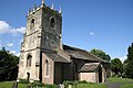
church in Cantley, South Yorkshire, United Kingdom  | |||||
| Upload media | |||||
| Instance of | |||||
|---|---|---|---|---|---|
| Dedicated to | |||||
| Location | Cantley, Doncaster, South Yorkshire, Yorkshire and the Humber, England | ||||
| Diocese | |||||
| Heritage designation |
| ||||
| Religion or worldview | |||||
| official website | |||||
 | |||||
Media in category "St Wilfrid's Church, Cantley"
The following 2 files are in this category, out of 2 total.
-
 St.Wilfrid's church, Cantley - geograph.org.uk - 173900.jpg 640 × 427; 62 KB
-
 St.Wifrid's church, Cantley - geograph.org.uk - 173902.jpg 640 × 427; 60 KB

Categories:
- 13th-century churches in South Yorkshire
- Anglican churches in South Yorkshire
- Cantley, South Yorkshire
- Churches in the Metropolitan Borough of Doncaster
- Churches in the Diocese of Sheffield
- Churches restored by George Gilbert Scott
- Grade II* listed churches in South Yorkshire
- Saint Wilfrid churches in South Yorkshire
- Works by Ninian Comper
- Hall churches in South Yorkshire
- Pseudobasilicas in South Yorkshire