Category:St. Barbara (Weibern)
Jump to navigation
Jump to search
| Object location | | View all coordinates using: OpenStreetMap |
|---|
parish church _Katholische_Kirche_Turm796.JPG) | |||||
| Upload media | |||||
| Instance of | |||||
|---|---|---|---|---|---|
| Location | Weibern, Brohltal, Ahrweiler, Rhineland-Palatinate, Germany | ||||
| Architectural style | |||||
| Heritage designation | |||||
 | |||||
Subcategories
This category has only the following subcategory.
Media in category "St. Barbara (Weibern)"
The following 5 files are in this category, out of 5 total.
-
 St. Barbara (Weibern) 01.jpg 3,136 × 4,704; 1.88 MB
-
 St. Barbara (Weibern) 02.jpg 3,208 × 5,498; 6.56 MB
-
 St. Barbara (Weibern) 03.jpg 4,024 × 6,048; 5.36 MB
-
 St. Barbara (Weibern) 04.jpg 5,211 × 3,474; 5.15 MB
-
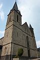 Weibern (Eifel) Katholische Kirche Turm796.JPG 2,520 × 3,776; 3.35 MB
_01.jpg)
_02.jpg)
_03.jpg)
_04.jpg)