Category:St. Bartholomäus (Gleißenberg)
Jump to navigation
Jump to search
| Object location | | View all coordinates using: OpenStreetMap |
|---|
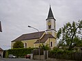
building in Gleißenberg, Upper Palatinate, Germany  | |||||
| Upload media | |||||
| Instance of | |||||
|---|---|---|---|---|---|
| Location | Gleißenberg, Cham, Upper Palatinate, Bavaria, Germany | ||||
| Street address |
| ||||
| Has part(s) |
| ||||
| Heritage designation | |||||
 | |||||
This is the category of the Bavarian Baudenkmal (cultural heritage monument) with the ID D-3-72-128-2 (Wikidata)
|
Subcategories
This category has the following 2 subcategories, out of 2 total.
Media in category "St. Bartholomäus (Gleißenberg)"
The following 32 files are in this category, out of 32 total.
-
 GleissenbergKirche 01.JPG 2,304 × 1,704; 570 KB
-
 GleissenbergKirche 02.JPG 2,304 × 1,704; 477 KB
-
 GleissenbergKirche 03.JPG 2,304 × 1,704; 469 KB
-
 GleissenbergKirche 04.JPG 2,304 × 1,704; 671 KB
-
 GleissenbergKirche 05.JPG 2,304 × 1,704; 566 KB
-
 GleissenbergKirche 06.JPG 2,304 × 1,704; 557 KB
-
 GleissenbergKirche 07.JPG 2,304 × 1,704; 451 KB
-
 GleissenbergKirche 08.JPG 2,304 × 1,704; 362 KB
-
 GleissenbergKirche 09.JPG 2,304 × 1,704; 457 KB
-
 GleissenbergKirche 10.JPG 2,304 × 1,704; 520 KB
-
 GleissenbergKirche 11.JPG 2,304 × 1,704; 400 KB
-
 GleissenbergKirche 12.JPG 2,304 × 1,704; 637 KB
-
 GleissenbergKirche 13.JPG 2,304 × 1,704; 437 KB
-
 GleissenbergKirche 14.JPG 2,304 × 1,704; 479 KB
-
 GleissenbergKirche 15.JPG 2,304 × 1,704; 686 KB
-
 GleissenbergKirche 16.JPG 2,304 × 1,704; 660 KB
-
 GleissenbergKirche 17.JPG 2,304 × 1,704; 717 KB
-
 GleissenbergKirche 18.JPG 2,304 × 1,704; 646 KB
-
 GleissenbergKirche 19.JPG 2,304 × 1,704; 721 KB
-
 GleissenbergKirche 20.JPG 2,304 × 1,704; 913 KB
-
 GleissenbergKirche 21.JPG 2,304 × 1,704; 940 KB
-
 GleissenbergKirche 22.JPG 2,304 × 1,704; 775 KB
-
 GleissenbergKirche 23.JPG 2,304 × 1,704; 929 KB
-
 GleissenbergKirche 24.JPG 2,304 × 1,704; 889 KB
-
 GleissenbergKirche 25.JPG 2,304 × 1,704; 881 KB
-
 GleissenbergKirche 26.JPG 2,304 × 1,704; 682 KB
-
 GleissenbergKirche 27.JPG 2,304 × 1,704; 520 KB
-
 GleissenbergKirche 28.JPG 2,304 × 1,704; 508 KB
-
 GleissenbergKirche 29.JPG 2,304 × 1,704; 531 KB
-
 GleissenbergKirche 30.JPG 2,304 × 1,704; 368 KB
-
 GleissenbergKirche 31.JPG 2,304 × 1,704; 861 KB
-
 GleissenbergKirche 32.JPG 2,304 × 1,704; 899 KB


