Category:St. Bartholomäus (Rödelsee)
Jump to navigation
Jump to search
| Object location | | View all coordinates using: OpenStreetMap |
|---|
cultural heritage monument D-6-75-161-7 (0) in Rödelsee, Bavaria  | |||||
| Upload media | |||||
| Instance of | |||||
|---|---|---|---|---|---|
| Named after | |||||
| Location | Rödelsee, Kitzingen, Lower Franconia, Bavaria, Germany | ||||
| Street address |
| ||||
| Architectural style | |||||
| Heritage designation | |||||
 | |||||
This is the category of the Bavarian Baudenkmal (cultural heritage monument) with the ID D-6-75-161-7 (Wikidata)
|
Media in category "St. Bartholomäus (Rödelsee)"
The following 22 files are in this category, out of 22 total.
-

-
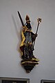
 Figur 2, Kath., Rödelsee.JPG 2,592 × 3,872; 3.1 MB
-
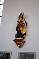
 Figur, Kath., Rödelsee.JPG 2,592 × 3,872; 3.11 MB
-
 Gefallenentafel, WW 1, Kath., Rödelsee.JPG 2,592 × 3,872; 4.14 MB
-
 Gefallenentafel, WW 2, Kath., Rödelsee.JPG 2,592 × 3,872; 4.46 MB
-
 Hochaltar, Kath., Rödelsee.JPG 2,592 × 3,872; 3.8 MB
-
 Jesusfigur, Kath., Rödelsee.JPG 2,592 × 3,872; 3.5 MB
-
 Kathkirche.jpg 1,159 × 1,511; 1.02 MB
-
 Katholische Bartholomäuskirche 2, Rödelsee.JPG 2,592 × 3,872; 3.74 MB
-
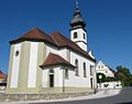 Katholische Kirche Rödelsee.jpg 1,327 × 1,041; 780 KB
-
 Madonna, Kath., Rödelsee.JPG 2,592 × 3,872; 3.39 MB
-
 Orgelempore, Kath., Rödelsee.JPG 3,872 × 2,592; 3.62 MB
-
 Roedelsee StBartholomaeus.jpg 925 × 1,395; 181 KB
-
 Rödelsee Katholische Kirche 001.jpg 3,264 × 4,928; 4.9 MB
-
 Rödelsee Katholische Kirche 002.jpg 3,264 × 4,928; 5.76 MB
-
 Rödelsee Katholische Kirche 003.jpg 3,264 × 4,928; 6.04 MB
-
 Rödelsee Katholische Kirche 004.jpg 3,264 × 4,928; 3.81 MB
-
 Rödelsee Katholische Kirche 005.jpg 3,264 × 4,928; 4.88 MB
-
 Rödelsee St. Bartholomäus 199.JPG 2,592 × 3,888; 7.25 MB
-
 Rödelsee St. Bartholomäus 209.JPG 2,592 × 3,888; 6.59 MB
-
 Rödelsee, Kath. Kirche, 001.jpg 3,264 × 4,928; 8.14 MB
-
 Rödelsee, Kath. Kirche, 002.jpg 4,928 × 3,264; 9.27 MB


