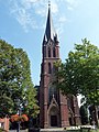
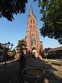
Category:St. Hubertus (Rheurdt-Schaephuysen)
Jump to navigation
Jump to search
| Object location | | View all coordinates using: OpenStreetMap |
|---|
 .JPG) | |||||
| Upload media | |||||
| Instance of | |||||
|---|---|---|---|---|---|
| Location | Schaephuysen, Rheurdt, Kleve, Düsseldorf Government Region, North Rhine-Westphalia, Germany | ||||
| Heritage designation | |||||
 | |||||
Media in category "St. Hubertus (Rheurdt-Schaephuysen)"
The following 14 files are in this category, out of 14 total.
-
 Choir St Hubertus (Rheurdt-Schaephuysen).JPG 3,456 × 4,608; 2.11 MB
-
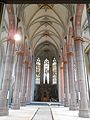 Interior St Hubertus (Rheurdt-Schaephuysen).JPG 3,456 × 4,608; 2.29 MB
-
 Kath Kirche in Schaephuysen - panoramio.jpg 3,000 × 4,000; 3.27 MB
-
 Schaephuysen - Kath. Pfarrkirche St. Hubertus - panoramio (1).jpg 3,000 × 4,000; 3.26 MB
-
 Schaephuysen - Kath. Pfarrkirche St. Hubertus - panoramio.jpg 3,000 × 4,000; 3.61 MB
-
 Schaephuysen church st hubertus.jpg 2,048 × 1,536; 431 KB
-
 St. Hubertus (Schaephuysen) (1).jpg 3,456 × 4,608; 6.43 MB
-
 St. Hubertus (Schaephuysen) (2).jpg 3,456 × 4,608; 5.1 MB
-
 St. Hubertus (Schaephuysen) (3).jpg 3,456 × 4,608; 8.55 MB
-
 St. Hubertus (Schaephuysen) (4).jpg 3,456 × 4,608; 7 MB
-
 St. Hubertus (Schaephuysen) (5).jpg 3,456 × 4,608; 6.31 MB
-
 St. Hubertus (Schaephuysen) (6).jpg 4,608 × 3,456; 5.58 MB
-
 St. Hubertus (Schaephuysen) (7).jpg 4,608 × 3,456; 5.19 MB
-
 Tower St Hubertus (Rheurdt-Schaephuysen).JPG 3,456 × 4,608; 2.95 MB
.JPG)

.jpg)

_(1).jpg)
_(2).jpg)
_(3).jpg)
_(4).jpg)
_(5).jpg)
_(6).jpg)
_(7).jpg)
.JPG)
Categories:
- Churches in Rheurdt
- Cultural heritage monuments in Rheurdt
- Schaephuysen
- Saint Hubertus churches in North Rhine-Westphalia
- Churches in Dekanat Geldern
- Gothic Revival brick churches in Kreis Kleve
- Gerhard Franz Langenberg
- Pseudobasilicas in Regierungsbezirk Düsseldorf
- Gothic Revival churches in Regierungsbezirk Düsseldorf
- Gothic Revival brick churches in Regierungsbezirk Düsseldorf
- 1890s churches in Regierungsbezirk Düsseldorf