Category:St. Margaretha (Kastl)
Jump to navigation
Jump to search
| Object location | | View all coordinates using: OpenStreetMap |
|---|
| Upload media | |||||
| Instance of | |||||
|---|---|---|---|---|---|
| Location | Kastl, Tirschenreuth, Upper Palatinate, Bavaria, Germany | ||||
| Street address |
| ||||
| Has part(s) |
| ||||
| Heritage designation | |||||
 | |||||
Subcategories
This category has only the following subcategory.
P
Media in category "St. Margaretha (Kastl)"
The following 4 files are in this category, out of 4 total.
-
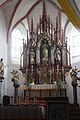 Kastl bei Kemnath Dorfkirche Altar.jpg 1,701 × 2,551; 1.18 MB
-
 Kastl bei Kemnath Dorfkirche Innenansicht.jpg 2,551 × 1,701; 930 KB
-
 Kastl bei Kemnath, Blick zur Dorfkirche.JPG 1,701 × 2,551; 768 KB
-
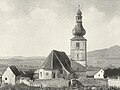 Kdkb 1907 kemnath 0045.jpg 1,000 × 750; 234 KB


Categories:
- Buildings in Kastl (bei Kemnath)
- Cultural heritage monuments in Kastl (bei Kemnath)
- Churches in Landkreis Tirschenreuth
- Gothic churches in Landkreis Tirschenreuth
- Churches in Dekanat Tirschenreuth-Wunsiedel
- Saint Margaret of Antioch churches in Upper Palatinate
- Gothic hall churches in Upper Palatinate
- Gothic churches in Upper Palatinate
- Hall churches in Upper Palatinate
- 14th-century churches in Upper Palatinate
- 15th-century churches in Upper Palatinate