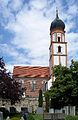
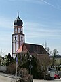
Category:St. Michael (Bad Griesbach im Rottal)
Jump to navigation
Jump to search
| Object location | | View all coordinates using: OpenStreetMap |
|---|
building in Bad Griesbach im Rottal, Lower Bavaria, Germany   | |||||
| Upload media | |||||
| Instance of | |||||
|---|---|---|---|---|---|
| Named after | |||||
| Location | Bad Griesbach im Rottal, Passau, Lower Bavaria, Bavaria, Germany | ||||
| Street address |
| ||||
| Heritage designation | |||||
 | |||||
This is the category of the Bavarian Baudenkmal (cultural heritage monument) with the ID D-2-75-124-21 (Wikidata)
|
Subcategories
This category has only the following subcategory.
Media in category "St. Michael (Bad Griesbach im Rottal)"
The following 7 files are in this category, out of 7 total.
-
 Ehem. katholische Pfarrkirche 1.jpg 2,397 × 3,596; 2.72 MB
-
 Ehem. katholische Pfarrkirche 1a.jpg 2,592 × 3,888; 2.83 MB
-
 Ehem. katholische Pfarrkirche.jpg 2,520 × 3,779; 3.11 MB
-
 Friedhofskirche St. Michael Schloßberg 11 Bad Griesbach, Ansicht von Südosten.jpg 7,111 × 4,000; 15.32 MB
-
 Friedhofskirche St. Michael Schloßberg 11 Bad Griesbach, Ansicht von Südwesten.jpg 6,670 × 3,752; 20.08 MB
-
 Friedhofskirche St. Michael, Bad Griesbach.jpg 1,690 × 2,600; 3.15 MB
-
 St. Michael Bad Griesbach im Rottal.JPG 2,448 × 3,264; 3.19 MB


