Category:St Catherine's Institute, Birkenhead
Jump to navigation
Jump to search
| Object location | | View all coordinates using: OpenStreetMap |
|---|
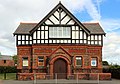
Former church hall, was used as a recruiting centre for the Birkenhead Bantams in World War I and is now home to scout and guide troupes.
Media in category "St Catherine's Institute, Birkenhead"
The following 4 files are in this category, out of 4 total.
-
 Datestone of St Catherine's Institute, Birkenhead.jpg 4,904 × 3,145; 17.92 MB
-
 Foundation stone of St Catherine's Institute, Birkenhead.jpg 4,389 × 3,182; 12.25 MB
-
 St Catherine's Institute - geograph.org.uk - 314933.jpg 640 × 480; 75 KB
-
 St Catherine's Institute, Birkenhead.jpg 4,846 × 3,401; 15.55 MB


