Category:St John the Baptist's church, Sutton-at-Hone
Jump to navigation
Jump to search
| Object location | | View all coordinates using: OpenStreetMap |
|---|
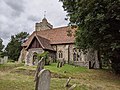
Grade I listed church in Sutton-at-Hone, Kent, United Kingdom  | |||||
| Upload media | |||||
| Instance of | |||||
|---|---|---|---|---|---|
| Dedicated to | |||||
| Location | Sutton-at-Hone, Sutton-at-Hone and Hawley, Dartford, Kent, South East England, England | ||||
| Diocese | |||||
| Heritage designation |
| ||||
| Inception |
| ||||
| Religion or worldview | |||||
 | |||||
Media in category "St John the Baptist's church, Sutton-at-Hone"
The following 10 files are in this category, out of 10 total.
-
 Archaeologia cantiana (1897) (14804687953).jpg 3,728 × 2,502; 1.48 MB
-
 Archaeologia cantiana (1900) (14597590998).jpg 3,696 × 2,256; 1.43 MB
-
 St John the Baptist Church, Sutton at Hone (geograph 2762127).jpg 4,000 × 3,000; 4.3 MB
-
 St John The Baptist Church, Sutton at Hone 01.jpg 4,032 × 3,024; 5.77 MB
-
 St John The Baptist Church, Sutton at Hone 02.jpg 4,032 × 3,024; 5.13 MB
-
 St John The Baptist Church, Sutton at Hone 03.jpg 4,032 × 3,024; 6.01 MB
-
 St John The Baptist Church, Sutton at Hone 04.jpg 4,032 × 3,024; 6.97 MB
-

-
 Sutton at Hone church (geograph 3153154).jpg 640 × 480; 141 KB
-
 St. Johns Church, Sutton-at-Hone (geograph 2207081).jpg 1,151 × 778; 467 KB
_(14804687953).jpg)
_(14597590998).jpg)
.jpg)


.jpg)
.jpg)