Category:Stadtkirche St. Trinitatis (Genthin)
Jump to navigation
Jump to search
|
Stadtkirche St. Trinitatis (Genthin) has an entry on OpenStreetMap (show). |
| Object location | | View all coordinates using: OpenStreetMap |
|---|
church building in Genthin, Germany  | |||||
| Upload media | |||||
| Instance of | |||||
|---|---|---|---|---|---|
| Named after | |||||
| Location | Genthin, Jerichower Land, Saxony-Anhalt, Germany | ||||
| Architectural style | |||||
| Heritage designation | |||||
 | |||||
This is the category of the Saxony-Anhalt Kulturdenkmal (cultural heritage monument) with the ID 09476344 (Wikidata)
|
Media in category "Stadtkirche St. Trinitatis (Genthin)"
The following 17 files are in this category, out of 17 total.
-
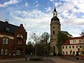
 Genthin, JL - Kirche St Trinitatis v NW.jpg 4,000 × 3,000; 3.52 MB
-
 Genthin, Sachsen-Anhalt - Kirche mit Pfarrhaus (Zeno Ansichtskarten).jpg 2,143 × 1,409; 184 KB
-
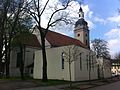
 St Trinitatis Genthin 2011 01.jpg 1,936 × 2,592; 1.93 MB
-
 St Trinitatis Genthin 2012 01.jpg 2,592 × 1,936; 1.73 MB
-
 St Trinitatis Genthin 2012 02.jpg 1,936 × 2,592; 1.66 MB
-
 St Trinitatis Genthin 2012 03.jpg 2,592 × 1,936; 1.89 MB
-
 St. Trinitatis (Genthin) 01.jpg 3,249 × 4,692; 8.73 MB
-
 St. Trinitatis (Genthin) 02.jpg 3,344 × 5,324; 12.43 MB
-
 St. Trinitatis (Genthin), Sanierung 01.jpg 1,000 × 1,839; 318 KB
-
 St. Trinitatis (Genthin), Sanierung 02.jpg 1,000 × 1,219; 286 KB
-
 St. Trinitatis (Genthin), Sanierung 03.jpg 1,262 × 1,000; 326 KB
-
 St. Trinitatis (Genthin), Sanierung 04.jpg 1,000 × 1,506; 149 KB
-
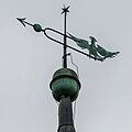 St. Trinitatis (Genthin), Wetterfahne.jpg 1,000 × 1,000; 93 KB
-
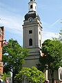 Trinitatis Kirche in Genthin am Markt.JPG 768 × 1,024; 150 KB
-
 Trinitatiskirche am Markt in Genthin.JPG 360 × 480; 36 KB
-
 Trinitatiskirche Genthin.jpg 640 × 480; 69 KB
-
 Wasserturm Genthin.jpg 567 × 567; 80 KB
.jpg)


_01.jpg)
_02.jpg)
,_Sanierung_01.jpg)
,_Sanierung_02.jpg)
,_Sanierung_03.jpg)
,_Sanierung_04.jpg)
,_Wetterfahne.jpg)


