Category:Stallstadel (Reichenau)
Jump to navigation
Jump to search
| Object location | | View all coordinates using: OpenStreetMap |
|---|
 | |||||
| Upload media | |||||
| Instance of | |||||
|---|---|---|---|---|---|
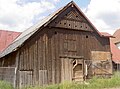
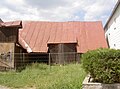
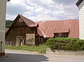
| Location | Waidhaus, Neustadt an der Waldnaab, Upper Palatinate, Bavaria, Germany | ||||
| Street address |
| ||||
| Heritage designation | |||||
 | |||||
This is the category of the Bavarian Baudenkmal (cultural heritage monument) with the ID D-3-74-164-33 (Wikidata)
|
Media in category "Stallstadel (Reichenau)"
The following 10 files are in this category, out of 10 total.
-
 ReichenauStallstadel 01.jpg 2,304 × 1,704; 882 KB
-
 ReichenauStallstadel 02.jpg 2,304 × 1,704; 801 KB
-
 ReichenauStallstadel 03.jpg 2,304 × 1,704; 770 KB
-
 ReichenauStallstadel 04.jpg 2,304 × 1,704; 877 KB
-
 ReichenauStallstadel 05.jpg 2,304 × 1,704; 912 KB
-
 ReichenauStallstadel 06.jpg 2,304 × 1,704; 911 KB
-
 ReichenauStallstadel 07.jpg 2,304 × 1,704; 810 KB
-
 ReichenauStallstadel 08.jpg 2,304 × 1,704; 944 KB
-
 ReichenauStallstadel 09.jpg 2,304 × 1,704; 890 KB
-
 ReichenauStallstadel 10.jpg 2,304 × 1,704; 812 KB


