Category:Stanbridge, Bedfordshire
Jump to navigation
Jump to search
village and civil parish in Bedfordshire, England .jpg) | |||||
| Upload media | |||||
| Instance of | |||||
|---|---|---|---|---|---|
| Location | Central Bedfordshire, Bedfordshire, East of England, England | ||||
 | |||||
English: Stanbridge is a village in Bedfordshire which lies east of Leighton Buzzard. It also borders the Bedfordshire villages of Hockliffe, Eggington, Tilsworth, Totternhoe and Billington.
Subcategories
This category has only the following subcategory.
Media in category "Stanbridge, Bedfordshire"
The following 36 files are in this category, out of 36 total.
-

-
 Anglo-Saxon silver strip.jpg 2,048 × 1,536; 545 KB
-
 Army cadet hut - geograph.org.uk - 3411553.jpg 1,600 × 1,068; 386 KB
-
 Bridleway along a disused road - geograph.org.uk - 3411559.jpg 1,600 × 1,068; 647 KB
-
 Disused road near Stanbridge - geograph.org.uk - 183129.jpg 640 × 480; 125 KB
-
 Entrance to caravan park on Leighton Road - geograph.org.uk - 5279469.jpg 2,264 × 1,672; 998 KB
-
 Entrance to Leighton Rugby Club - geograph.org.uk - 3411577.jpg 1,600 × 1,068; 484 KB
-
 Farm track - geograph.org.uk - 3411572.jpg 1,600 × 1,069; 522 KB
-
 Footpath across the field - geograph.org.uk - 3411540.jpg 1,600 × 1,069; 684 KB
-
 Footpath to Blackgrove Wood - geograph.org.uk - 3411534.jpg 1,600 × 1,068; 612 KB
-
 Footpath to Stanbridge - geograph.org.uk - 3411542.jpg 1,200 × 1,600; 584 KB
-
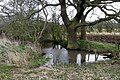
 Hidden brook - geograph.org.uk - 1393538.jpg 640 × 480; 349 KB
-
 Insurance plaque - geograph.org.uk - 4155934.jpg 683 × 1,024; 152 KB
-
 Kink in the Ouzel Brook - geograph.org.uk - 1393523.jpg 640 × 480; 340 KB
-
 Muddy pool by the footpath - geograph.org.uk - 3411538.jpg 1,600 × 1,068; 719 KB
-
 Old Mill Stanbridge - geograph.org.uk - 3849712.jpg 4,320 × 3,240; 2.9 MB
-
 Paddock by Orchard Way - geograph.org.uk - 3411528.jpg 1,600 × 1,068; 591 KB
-
 Phone mast by the rugby club - geograph.org.uk - 3411570.jpg 1,200 × 1,600; 500 KB
-
 Pond in the paddock - geograph.org.uk - 3411549.jpg 1,600 × 1,066; 587 KB
-
 Public Footpath - geograph.org.uk - 2305404.jpg 1,704 × 2,272; 1.12 MB
-
 Roadside brook - geograph.org.uk - 3411563.jpg 1,600 × 1,068; 655 KB
-
 Sewell Greenway - Cycle path - geograph.org.uk - 1393550.jpg 640 × 480; 314 KB
-
 Sign of the Five Bells - geograph.org.uk - 4155917.jpg 1,024 × 683; 166 KB
-
 St John the Baptist, Stanbridge - geograph.org.uk - 3849699.jpg 4,320 × 3,240; 4.34 MB
-
 St. John the Baptist, Stanbridge - geograph.org.uk - 2181781.jpg 1,704 × 2,272; 685 KB
-
 Stanbridge church - geograph.org.uk - 4666820.jpg 640 × 480; 113 KB
-
 Stanbridge Road, Billington - geograph.org.uk - 5279512.jpg 2,304 × 1,728; 844 KB
-
 Stanbridge windmill new cap.jpg 480 × 640; 88 KB
-
 Stanbridge, St John the Baptist - geograph.org.uk - 5441422.jpg 4,608 × 3,456; 5.31 MB
-
 The 5 Bells, Stanbridge - geograph.org.uk - 637856.jpg 640 × 480; 114 KB
-
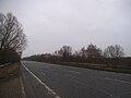 The A505, Stanbridgeford - geograph.org.uk - 5279840.jpg 2,304 × 1,728; 861 KB
-
 The End of the Road - geograph.org.uk - 182692.jpg 640 × 480; 122 KB
-
 The Five Bells - geograph.org.uk - 4155725.jpg 1,024 × 683; 181 KB
-
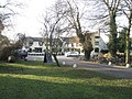
 The Green, Stanbridge - geograph.org.uk - 183131.jpg 640 × 480; 97 KB
-
 The long drive to the Five Bells Pub, Stanbridge - geograph.org.uk - 3849684.jpg 4,320 × 3,240; 2.89 MB
-
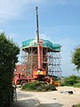
 Telecoms mast, Leighton Road - geograph.org.uk - 182680.jpg 480 × 640; 92 KB


